Route 120 Corridor – May 17, 2008
Search Results for: route 120
Route 120 Corridor Map
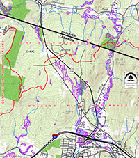
Route 120 Corridor Map – as of May 17, 2008
Route 120 Corridor Vision Statement
Route 120 Corridor Vision Statement – February 2009
Protection of Natural Habitat in the Route 120 Corridor
Rt. 120 – Mount Support

PROTECTION OF NATURAL HABITAT in the Route 120 Corridor
The Route 120 Corridor in Lebanon and Hanover contains some astounding beauty and ruggedness, with habitats harboring an exceptional richness of wildlife.
Although commercial and residential developments are prevalent along the major roadways (Rt. 120, Greensboro Road and Great Hollow Road), the interior contains more than 500 acres of contiguous forest with diverse habitats and natural features. It is truly a unique landscape worthy of protection.
With further development slated for this growing area, many residents attended public meetings in 2007 and 2008 to expressed their desire to protect the “wild” areas in this corridor. Both Lebanon and Hanover residents voiced their support for this ecologically and geologically diverse area, and their commitment to maintaining its environmental quality.
We recognize the ecological value of the 120 Corridor, and strongly agree with the many residents committed to its protection. The Hanover Conservancy envisions the permanent conservation of this relatively wild core interior area with its diverse flora and fauna, fragile wetlands, critical wildlife corridors, and distinctive geological features. To that end, we have begun working to forge partnerships, facilitate discussions, and begin the necessary steps to make this happen for the future of our communities.
This is a unique opportunity for our two communities to work together to maintain the integrity of this special wilderness. Bears, birds and other wildlife have no concern for town boundaries as they move about the forest. Let us not limit our conservation actions by some line on a map.
THE LAND
It is remarkable that, so close to our town centers, there are lands with qualities we generally associate with much more extensive and remote wilderness. Fortunately, the ruggedness of these areas and long-term stable ownership have protected them from major disturbances in the past.
The core habitat areas of the 120 Corridor are bordered by three major roads: Rte 120, Greensboro Road and Great Hollow Road (see map). The northern part of the 120 Corridor drains to Mink Brook, the southern part to the Mascoma River, and both of these flow to the Connecticut River. This large interior forested area includes Mt. Support, Rix Ledges, many wetlands that support rare species and plant community types on a diverse terrain of large boulders and outcrops.
A network of adjacent conservation lands provides travel corridors for wildlife, and increase the conservation value of the Route 120 Corridor. These neighboring conservation lands include the Appalachian Trail, Mink Brook Nature Preserve, Greensboro Ridge Natural Area, Hypertherm Wetlands and Great Hollow Forest in Hanover, and Indian Ridge, the Landmark Tract, and Boston Lot Lake in Lebanon.
A. THE CASE FOR LAND PROTECTION:
Multiple reports (e.g., Lebanon’s Natural Resource Inventory, and work by The Nature Conservancy and NH Fish and Game) document the many wetland areas, small streams, rich deciduous forests, high quality wildlife habitat, rare plants and unusual rock formations in the Rt. 120 corridor. Noteworthy features include:
- Quality habitat and populations of bear, moose, bobcat and other mammals, characteristic of wilderness areas in New England
- Exemplary bog and acidic seepage swamp habitats
- Barrens strawberry -included on the state’s list of threatened plants
- Stream edges include hemlock talus forests and mixed hardwood deciduous forests
- Extensive forested wetlands with streams flowing north to Mink Brook
- Glacial erratics, boulder fields, ridges, rock faces and amphitheaters
- Extensive bands of maidenhair fern, rattlesnake plantain and cathedral pines.
- Examples of near-old-growth trees
Furthermore, the 2008 NH Fish and Game Department report emphasizes that land conservation efforts are critical for the significant wildlife movement that takes place in the corridor.
B. CONSERVATION PRIORITIES
The Conservancy believes that community plans must protect core natural areas, and separate these undisturbed natural areas from commercial and residential developments with adequate buffer zones. We encourage the use of “smart growth” principles which concentrate buildings near existing infrastructure and conserve open lands and access routes that minimize environmental damage. Project planning must consider these objectives.
- Core natural habitat in the 120 Corridor must be protected from disturbance and increased development. Preserve existing wildlife corridors in the interior and create new ones across roads and developed areas.
- Buffer streams to protect water quality.
- Protect Mount Support and Rix Ledges. These are important examples of geologically uplifted lands with very dramatic topography. This accentuates their remote, wild character.
- Any public access trails should be kept at a minimum and be near developments, avoiding the most sensitive lands.
C. CURRENT STATUS
The City of Lebanon has now granted approval for Phase I of development on 15 acres at the former Wilson Tire site. Conservation of lands on the Lebanon side is included in plans for a later phase that is currently contingent upon further approvals and an inter-municipal agreement to address sewerage treatment. On the Hanover side, discussions have not yet advanced.
CONCLUSION
It is essential to develop an overarching plan for future developments in the 120 Corridor. We need to think beyond our human town boundaries and avoid piecemeal development approvals to define the overall character of this unique area. The Hanover Conservancy supports the conservation of this large, core natural area while development moves forward under smart growth principles.
Rt. 120 Corridor – Mt. Support
The Hanover Conservation Council has been working to gather and share information on the ecologically important lands in the Route 120 Corridor in both Hanover and Lebanon. Please read the Rt. 120 Corridor Vision Statement from the Hanover Conservation Council for this area.
Mink Link Loop
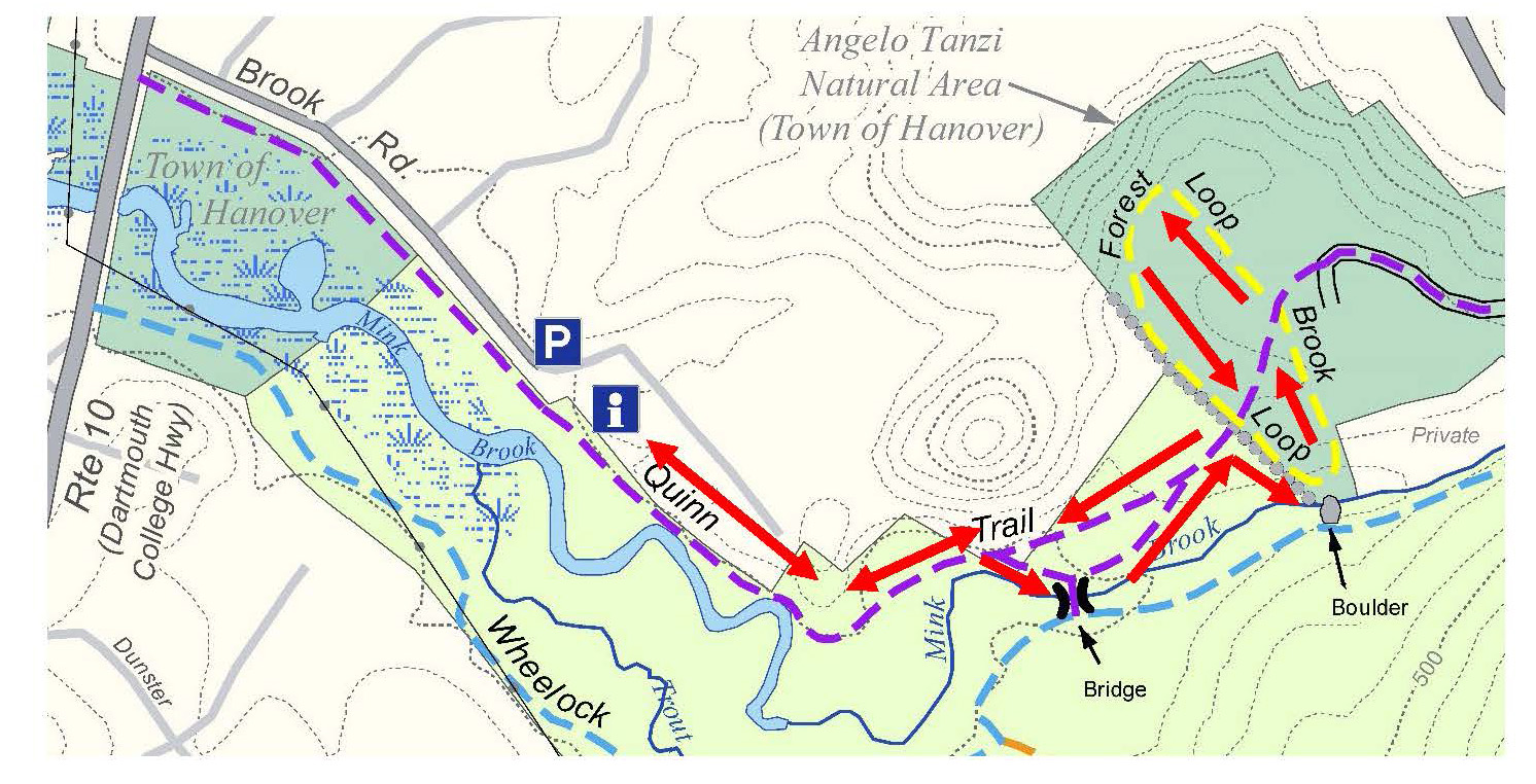
An easy loop in the Mink Brook Nature Preserve close to downtown, visiting an Eagle Scout project.
Distance: 1.0 mile round trip
Elevation gain: 30 feet
Time: 45 minutes
Categories: Bears, Hike of the Month, March, Mink Brook, Trails
Tags: Mink Brook, hike
DOWNLOAD FULL DIRECTIONS – PDF
Driving directions:
- From downtown Hanover, drive south on Main Street (Route 10) 0.5 miles to Brook Road.
- Turn L just before Route 10 crosses Mink Brook.
- Follow Brook Road for 0.1 mile to a sharp bend.
- Park here near the trailhead gate.
What you should know:
- Dogs are welcome but must be under close control (better yet, leashed); please pick up after your pet.
- Foot travel only. Bicycles are not permitted in the Mink Brook Nature Preserve.
- The Preserve is home to bears who may emerge from hibernation as early as March (another reason to leash your dog). If you happen to encounter a bear, do not run but speak softly to it and move away slowly. Mother bears are as protective of their young as we are.
- You are visiting the 112-acre Mink Brook Nature Preserve, owned and managed by the Hanover Conservancy since 1999.
BRIEF HIKING DIRECTIONS
- Take the Quinn Trail through the gate and visit the kiosk.
- Continue on the Quinn Trail along the N side of Mink Brook, past the Norman Overlook.
- Bear R to cross the log bridge (one at a time).
- Turn R on the far side of the bridge onto the Wheelock Trail.
- After the Wheelock Trail turns L, bear L onto the Trout Brook Trail.
- Bear R onto the Mink Link across a set of bog bridges.
- The Mink Link meets the Sachem Connector at Trout Brook.
- Turn R onto the Sachem Connector and R again onto the Wheelock Trail.
- Bear L to stay on the Wheelock Trail where the Trout Brook Trail joins.
- Turn L to cross the log bridge and retrace your steps to your car.
FULL DIRECTIONS
- Take a moment to check the kiosk display and pick up a trail guide. Note the map outlining Mink Brook’s 18.5 square mile watershed.
- Hanover’s largest stream begins high on Moose Mountain at Mill Pond, gathering waters from other headwater streams and flowing through Etna, where it once powered so many mills that this village was first known as Mill Village. Below Etna, the brook turns and runs S of Greensboro Road through the Mink Brook Community Forest, protected in 2021. Crossing under Route 120 and past the remains of a mill built for Eleazar Wheelock, the brook rushes W through the Preserve toward the Connecticut River.
- Begin your walk on the easy, flat Quinn Trail, named for the Hanover family that helped protect this land in 1999. This part of the trail follows a buried sewer line marked by covers labeled “Hanover Sewer 1976.” While they seem out of place on a woodland walk, we can forgive the intrusion since the building of this sewer line to collect waste from hundreds of Hanover homes meant the transformation of Mink Brook and the Connecticut River from noxious open sewers back to the safe, clean waters they are today.
- Note the nature of the water in the brook. If ice-free, does it appear to be lazy and slow-moving, or is it locked silent under a cover of snow and ice? In this area, both the Connecticut and Mink Brook are pond-like, backed up behind Wilder Dam just downstream in Lebanon. Farther along the trail, stay alert for a change in character to the naturally free-flowing, musical stream that flows off the uplands.
5 minutes’ walk from the gate, the trail takes a sharp L by a crabapple tree. Pause here to note the thick, ropy stems of river grape (Vitis riparia) growing up the trees at L. This native vine is common along streams and offers a rich food source for birds and other wildlife.
- Now look R for traces of a path heading towards the brook through young pines. In the 1990s, a 30+ lot subdivision was laid out for the 112 acres of today’s Preserve. A road to serve the subdivision was to cross the brook here. Give a cheer for the 450 donors, the Quinn Family, and Dartmouth College for recognizing the natural value of this place and stepping up to help the Conservancy and Upper Valley Land Trust protect it. The Hanover Conservancy now owns and manages the land, with conservation deed restrictions from UVLT.
- Continue on the Quinn Trail, soon arriving at the Bob Norman Overlook at R, marked by slabs of granite offering a pleasant perch for observing the brook. Bob Norman, a founder of the Hanover Conservancy in 1961, was its President in 1999 when the Preserve was protected. A demonstration planting of native shrubs includes red osier (Cornus sericea), whose brilliant red stems are especially ornamental at this time of year. This handsome shrub is a great choice for wet areas, as it tolerates flooding and its white berries offer high quality food for wildlife later in the year. You may see it growing naturally nearby.
- At this point, the brook is clearly more lively, with patches of open water roiled by its flow. Wilder Dam may be far out of sight, but it controls the character and movement of Mink Brook here in the Preserve and of other tributaries as far north as Haverhill NH and Newbury VT, 45 miles upstream. The Hanover Conservancy is closely following re-licensing of this dam and current studies of how it affects erosion and sedimentation, fish, wildlife, invasive species, and even archeological sites. As this hike is published, a welcome new proposal from the hydropower company would alter dam management to more of a natural, run-of-river flow than an up-and-down “peaking” flow, meaning that more of Mink Brook would be allowed to behave like a proper brook instead of a pond.
- Note the erosion on the streambank near the tree line. Tropical Storm Irene sent so much water down Mink Brook in 2011 that the brook changed course upstream of the bridge and then began to work on the near bank just below it. Because the town’s sewer line runs close by, the Town of Hanover is intervening to protect the sewer line from erosion.
- It’s time to cross the brook. Bear R off the Quinn Trail toward the bridge.
- Our beautiful log bridge was crafted in 2009 from a nearby tree. Cross it with care (please don’t bounce).
- Through the millennia Mink Brook, or Mosbasak Zibosiz in the Abenaki language, has been a key part of local Abenaki village and subsistence grounds. From the time of Dartmouth’s founding, Abenaki and other Native families lived in this area to support their children who were enrolled in Moor’s Charity School and the College. Abenaki families have lived nearby to this day. This spot has long been known as a “woman’s place,” and when Wheelock arrived to raise his college, Abenaki grandmothers met with his people to lay out their rules for how the land would be used.
- Once across the stream, turn R onto the blue-blazed Wheelock Trail, named for Dartmouth’s founder, who was given this land and a mill privilege on Mink Brook as an incentive to locate his new college in Hanover.
- A few minutes past the bridge, swing L at a forked pine tree and away from the brook, up into the hemlocks.
- In a few paces, reach a trail junction and the beginning of your loop. The Wheelock Trail continues across a small drainage, but you stay L on the orange-blazed Trout Brook Trail, following the little rivulet upstream.
- Pass a big rock on the R and arrive at another trail fork marked with a “no bikes” sign. Just past the sign, bear R onto the Mink Link. Cross the wetland here on a new bog bridge.
- This crossing and another you’ll soon encounter were built in 2019 by Andrew Chen of Troop 45 for his Eagle Scout Project. The task was to create a dry crossing of split and peeled hemlock logs through a wetland that had been trampled by hikers making an informal shortcut. With feet on the bog bridge instead, the wetland should recover well. An incredible 176 hours went into this project. The Hanover Lions Club and the Rankin family contributed to the cost of materials. Thanks to all!
The Mink Link Trail moseys up and among the hemlocks and pines, soon reaching another of Andrew’s log crossings. Note a posted map at L marking the junction of the Mink Link and Sachem Connector Trails. Hop up on the bridge which crosses Trout Brook, a tributary that arises in Lebanon and offers good habitat for wild brook trout. The stiff fertile fronds of ostrich fern poke up through the snow in the small, damp floodplain close to the brook. Andrew’s bridge replaces another one that previously washed away in high water. Does the tame little stream you’re viewing today seem capable of such a feat?
- Return to the trail sign and bear L to take the Sachem Connector Trail up and around a small knoll. The trail is blazed red, but you won’t see the next blaze until you’ve gone around the bend. Note a large boulder oddly out of place on your L and imagine the power of the water – or ice – that dropped it here.
- 10 minutes from the Trout Brook Trail, you return to the Wheelock Trail, this time amid some impressively tall pines. Bear R at a Y around two of them.
- As you go, note the steep ridges at R that mark ancient channels of Mink Brook. This region was once inundated by the frigid waters of glacial Lake Hitchcock, and the clay/silt lake-bottom sediments were easily sliced by the rushing waters of the brook after the lake receded, leaving steep-sided ravines. Today’s Mink Brook follows on your L.
- 7 minutes after joining the Wheelock Trail, you return to the beginning of your loop, at a small drainage. Cross it and bear L. As the Wheelock Trail bends R, look L toward the brook and the spot where the proposed subdivision bridge was to carry a road to the 30+ homes planned for this spot. Imagine this place as a residential subdivision and yourself standing on a paved road leading to driveways, garages, mailboxes, landscaped yards, and houses with dogs and cats!
Cross the log bridge again, keeping an eye out for the elusive namesake of the brook, the mink. A member of the lithe weasel family, mink live near water and prey upon small fish, crayfish, and other aquatic delicacies. If you get a good look, you’ll see its distinctive white chin.
- Turn L on the far side of the bridge at the sign for the Quinn Trail.
- Follow the brook downstream 9 minutes to your car. If the stream is snow and ice-covered, check for animal tracks on its surface. Chances are you’ll see the straight line of small, evenly spaced tracks of red fox.
- Return to the gate and resolve to return as spring arrives at Mink Brook.
Note: The Hanover Conservancy seeks volunteers to monitor trails and help out with occasional work parties. We also warmly welcome donations to our Mink Brook Stewardship Fund to help maintain the Preserve. Get in touch at info@hanoverconservancy.org. For more about the Mink Brook Nature Preserve, visit www.hanoverconservancy.org/lands/mink-brook/.
This Hanover Hike of the Month is generously sponsored by
Snyder Donegan Real Estate Group
March, 2021