From downtown Hanover and the Green, follow Route 10 N for 4.2 miles to River Road and turn L.
Follow River Road for 0.5 mile.
Just past Purling Brooks Drive, cross Slade Brook near its confluence with the Connecticut River.
Turn immediately R into the small parking area.
What You Should Know
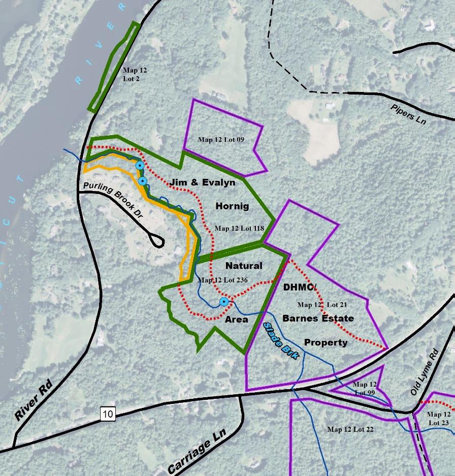
Today’s hike begins at the Hanover Conservancy’s Jim and Evalyn Hornig Natural Area at Lower Slade Brook. It continues on land owned by DHMC to Rt. 10, then follows Rt. 10 N to Pipers Lane. A short walk through this neighborhood ends at the Class VI section, a rough lane past town-owned land down to River Road, where you’ll enjoy river views on the way back to your car.
Bring binoculars and guides to both birds and wildflowers. Spring has arrived in all its diversity!
Foot travel only in the Natural Area.
Please pick up after your pet. Dogs must be under your strict control, especially while passing along Rt. 10 and through the Pipers Lane neighborhood.
The trail in the Natural Area is not blazed but is easy to follow. Wooden arrows and signs mark turns.
Brief Hiking Directions
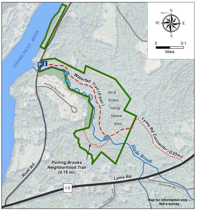
Start on the trail that begins at the kiosk.
After the third waterfall, the trail bears L and uphill. After leaving the Natural Area, turn R at signs for Rt. 10.
Turn L on Rte. 10 and follow the shoulder 0.4 miles to Pipers Lane.
Turn L on Pipers Lane and follow to its maintained end. Continue on the unmaintained section to River Road.
Turn L on River Road and walk 0.5 miles to return to your car.
Slade Brook watershed
The Full Story
Take a moment to check the kiosk display and map before embarking on the trail beyond the rocks.
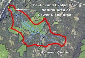
Slade Brook flows 4.0 miles from a wetland near Three Mile Road west to the Connecticut River, draining a largely forested 2.55 square mile watershed. Nearly a third of this watershed is permanently protected, including the 38-acre Lower Slade Brook Natural Area, Huntington Hill Wildlife Management Area, Moister Meadow, and several other parcels.
At this time of year, the dark green of stiff-stemmed horsetail, or scouring rush, is prominent. Our forebears used this primitive native plant, its tissues naturally fortified with silica, to scrub dishes.
The brook takes its name from Capt. Samuel Slade (1747-1826), a leading citizen of Hanover who came to town around 1774. He served in the Revolutionary War at Fort Ticonderoga. He, his wife Sarah, and their 13 children lived a mile north of Hanover Center (house later burned). His grandson, Samuel Thompson Slade (b. 1810) married a Huntington girl from the neighborhood. Generations of Slades are buried at Hanover Center.
Louisiana waterthrushIn May, migrating songbirds using the Connecticut River as a flyway will linger near the river in forests like this as they prepare to return to their upland breeding grounds. Listen as you walk for the Louisiana waterthrush. The male’s song is a musical, distinctive series of descending notes followed by a warble. The hilly forest surrounding Slade Brook offers prime habitat for this bird. The NH Fish & Game Department recognizes the Slade Brook corridor as among the highest quality habitat in the state.
The trail follows a gently rising path on a terrace above the brook that may have been an early tote road.
Within a few minutes’ walk from your car, the first flume comes into view and the trail heads up a short rise. A second flume appears above the first. They are at their sparkling best at this time of year.
The trail soon levels again and offers a view down onto the floodplain of the brook at R. The wet, mossy expanse hints at its value for storing water during heavy rains and snowmelt.
As you continue, the trail moves a short distance from the brook into a grove of hemlock, yellow birch, and white pine. Admire the birches’ glowing papery bark. Some, growing on the rotting remains of old fallen trees, are working on a giraffe imitation as their roots stretch down to the soil. The forest promises a cool retreat when you return on a hot summer day.
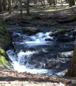
About 12 minutes’ walk from your car, you catch the sound of water again, drawing you a few feet off the trail to a log bench built by Conservancy volunteers. Here you can view the uppermost and largest waterfall. The brook tumbles down stepped ledges, hemmed in by a sheer moss-covered wall, and then sluices away to the SW through a short, narrow gorge. The entire 1,630 acre watershed drains through this slender point.
After admiring the falls, continue up the path. Stepping stones lead across the brook to a short (0.15 mile) side trail to the Purling Brooks neighborhood. The public may use this trail as far as the Natural Area boundary, but it’s not on our route today.
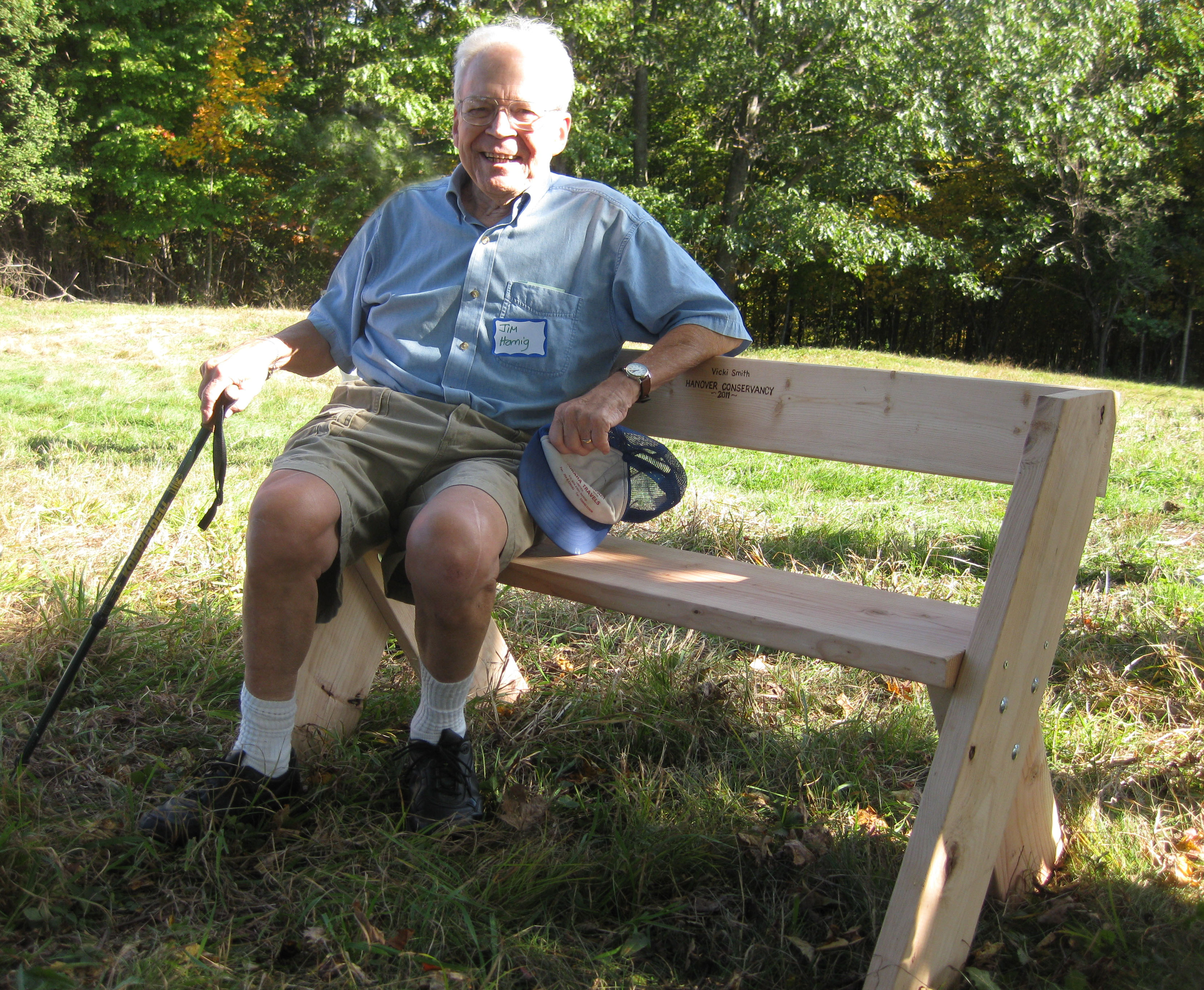
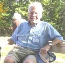
Jim HornigWhen a developer proposed 17 houses here, the Conservancy (then the Hanover Conservation Council) suggested an alternative that resulted in 10 homes clustered on 20 acres on the site of a former gravel pit S of the brook, with the rest of the property left intact. This solution protected the brook and its valley, allowing the public to enjoy the waterfalls and trails. The Conservancy also holds a conservation easement on the stream-side portions of the house lots on the far side. Jim Hornig, former president of the Council, was the inspiring force behind this idea, and in 2005 the Council named the Natural Area in honor of Jim (right) and his wife, Evalyn.
Watch for the sharp L turn as the trail heads away from the brook and somewhat steeply up to the height of land. About 5 minutes past the falls, you’ll see a remnant of barbed wire at R, marked with flagging, a reminder of the grazing history of this area.
The trail continues past the Conservancy boundary to a junction with signs. Turn R onto a nearly flat logging road that leads 0.25 miles to Rt. 10. An old stone wall, a reminder of this land’s former farming history, is at L.
You’re now passing over land bequeathed to the hospital that is occasionally logged for income. This becomes clear as you arrive at a wide log landing with a recently thinned (2017) red pine plantation at R.
5 minutes later, the sound of occasional traffic announces your arrival at Rt. 10, where a chain blocks the logging road. Turn L on Rt. 10 for the 10-minute walk on the shoulder of the wide state highway, a stark contrast to the historic Class VI road you’ll soon visit.
10 minutes later, turn L onto Pipers Lane. A one-room schoolhouse, known as the County Road School, stood on this corner from at least 1855 through 1892. By 1926 it had been moved across the road.
Now a dispersed residential neighborhood, this area was once part of the Piper Farm. Today, it’s something of a showcase for solar energy installations by ReVision Energy. At #2, a 8.4kW system has 30 modules mounted on the ground in two separate arrays that will produce 10,222 kWh/year of electricity. This also helps heat and cool the home with air source heat pumps. Nearby at #3, a 11.52 kW system with 36 roof-mounted modules can produce 10,587 kWh/year of electricity. A bit further down the lane, at #9, is a 10.24kW system with 32 modules that can produce nearly that amount.
This reminds us that the Dartmouth Organic Farm you may have passed on the way to River Road has a 9.8kW solar array put up by ReVision that has been operating since 2017. The array, mounted on the S side of the newer barn’s roof, is set to produce 11,000 kWh of electricity (14% of what the farm used then).
About 10 minutes’ gentle walk from Route 10, arrive at two architecturally distinct homes book-ending the last traveled portion of Pipers Lane. At L is a sleek modern home facing the beautiful Slade Brook Valley. Its open fields and forested edges are fine wildlife habitat. At R is an historic house, home in the 19th century to generations of the Smith family. Note the granite hitching post out front. (Map at R – 1892)
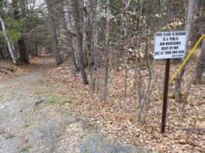
1892 mapThings are pretty quiet here now, but maybe less so 200 years ago. Laid out in 1816, this road connected River Road with “the County Road” (now Lyme Road/Route 10). In 1932, the steep, difficult-to-maintain lower (NW) end was finally discontinued and made subject to gates and bars. You’ll see why very shortly. By that time, it had been called Pipers Lane for decades, after the family owning the nearby farm. The town still owns the right of way over the old road, not the roadbed itself.
A few steps down the historic road, bear R at a Y, following an old stone wall at R topped with barbed wire, a reminder of open pastures of earlier times. Soon the road swings N as it follows the steep and winding path of a small drainage. This drainage, which you’ll be hopping over occasionally, may be not be impressive now, but at one time it had the power to gouge out the ravine you’re now descending. Indeed, this is a classic remnant of glacial Lake Hitchcock. This steep, narrow cut was carved out thousands of years ago by a wandering Slade Brook as it scoured through the soft lake-bottom sediments left behind by the retreating glacial lake. You can visit several other places in Hanover that exhibit this same dramatic effect: Trout Brook trail at the Mink Brook Nature Preserve, Kendal Riverfront Park, and the Rinker-Steele Natural Area.
Starting at the sharp bend in the old road, you’ll be passing the Beryl Piper Little Nature Preserve on the R for the next 1/3 mile. This 3.4 acre parcel was purchased by the Town of Hanover from the Piper family in 2004. Year-round, the looming slopes of the ravine are clothed with evergreen Christmas fern, but at this time of year, ephemeral spring wildflowers may pop up among them. Most are native, but you may find the cheerful, early yellow daisy-like flowers of introduced coltsfoot, especially in disturbed areas.
Near the bottom of the ravine you cross a forlorn heaved culvert, the bane of a road crew’s days. A sudden heavy storm uprooted it a few years ago as the old road washed out yet again.
This place might be a highway engineer’s nightmare, but it is also a dream for dogtooth violet, also known as trout lily. Its camouflaged leaves of green splotched with brown suddenly appear at this time of year, followed by single (sometimes two) nodding yellow down-ward facing lily flowers.
The old road eventually leads you to River Rd, near the junction of Grant Rd. The Connecticut itself appears beyond the houses perched just above its floodplain. Turn L for the easy ½-mile walk back to your car.
Just past #30 River Road, the river draws close. The Hanover Conservancy owns 900 feet of riverbank here, acquired in 2005 with the Lower Slade Brook Natural Area.
As you arrive back at your car, take a moment to view the confluence of tiny Slade Brook with the largest river in New England. From its headwaters in Hanover Center, its waters are now joining those of thousands of others on their way to Long Island Sound.
This Hanover Hike of the Month has been generously sponsored by
From downtown Hanover and the Green, follow Route 10 north for 4.2 miles to River Road and turn left.
Follow River Road for 0.5 mile.
Just past Purling Brooks Drive, cross Slade Brook near its confluence with the Connecticut River.
Turn immediately right into the small parking area.
What You Should Know
Foot travel only. Dogs are welcome but must be under close control; please pick up after your pet.
The trail is not blazed but is easy to follow. Wooden arrows mark important turns.
Hiking Directions
Take a moment to check the kiosk display and map before embarking on the trail beyond the rocks.
Slade Brook flows 4.0 miles from a wetland near Three Mile Road west to the Connecticut River, draining a largely forested 2.55 square mile watershed. Nearly a third of this watershed is permanently protected, including the 38-acre Lower Slade Brook Natural Area, Huntington Hill Wildlife Management Area, Moister Meadow, and several other parcels.
At this time of year, the dark green of stiff-stemmed horsetail, or scouring rush, is prominent. Our forebears used this primitive native plant, its tissues naturally fortified with silica, to scrub dishes.
The brook takes its name from Capt. Samuel Slade (1747-1826), described as a “leading citizen” of Hanover who came to town around 1774 and eventually served as tithing man, selectman, and representative. A Revolutionary War soldier, Slade was part of a committee to raise soldiers for the Continental Army and was stationed at Fort Ticonderoga. He, his wife Sarah, and their 13 children lived one mile north of Hanover Center (house later burned) and were prominent members of the Hanover Center church. His grandson, Samuel Thompson Slade (b. 1810) married a Huntington girl, so the family was clearly frequenting the neighborhood. Generations of Slades are buried at Hanover Center.
Shortly after leaving your car, note a dramatic ravine on the left. This steep, narrow cut was carved out thousands of years ago by Slade Brook as it scoured through lake-bottom sediments left behind by glacial Lake Hitchcock.
Listen as you walk for the Louisiana waterthrush. The male’s song is a musical, distinctive series of descending notes followed by a warble. One of the earlier neotropical migrants to return to its breeding grounds in the spring, this bird often arrives a month or more before other warblers. The hilly forest surrounding Slade Brook offers prime habitat for the waterthrush, as its name indicates.
On a terrace above the brook, the trail follows a very gently rising path that may once have been an old tote road. Evergreen Christmas fern decorates the banks at left.
As the trail bears to the right, the first flume comes into view and the trail heads up a short rise. A second flume appears above the first.
The trail soon levels again and offers a view down onto the floodplain of the brook. The wet, mossy expanse hints at its important function of storing water during heavy rains and snowmelt.
As you continue, the trail moves a short distance from the brook into a grove of hemlock, yellow birch, and white pine. Admire the birches’ glowing papery bark. Some, growing on the rotting remains of old fallen trees, are working on a giraffe imitation as their roots stretch down to the soil. The forest promises a cool retreat when you return on a hot summer day.
About 12 minutes’ walk from your car, you catch the sound of water again, drawing you off the trail a few feet to the right to view the uppermost waterfall. Here, the brook takes two paths down mossy stepped ledges, and then sluices away to the southwest through a short, narrow gorge. The entire flow from the brook’s 1,630 acre watershed passes through this point.
After admiring the falls, continue up the path.
Just beyond the falls, stepping stones lead across the brook to a short (0.15 mile) side trail to the Purling Brooks neighborhood. The public is welcome to use this trail as far as the Natural Area boundary, but may not continue across private land.
That brings us to the story behind the Natural Area’s protection in 2005. When a developer presented a plan for 17 houses in this area, the Conservancy (then the Hanover Conservation Council) proposed an alternative that resulted in 10 homes clustered on 20 acres on the south side of the brook, on the site of a former gravel pit, with the rest of the property left intact. This solution protected the brook and its undisturbed valley, while providing recreational trails for homeowners in the Purling Brooks neighborhood and the wider community. Jim Hornig, former president of the Council, was the inspiring force behind this idea, and the Council gratefully named the Natural Area in honor of Jim (right) and his wife, Evalyn.
Watch for the sharp left turn as the trail heads away from the brook and somewhat steeply up to a plateau. About 5 minutes past the falls, you’ll come to a remnant of barbed wire on the right, marked with flagging, a reminder of the grazing history of this area. This land was once part of the Piper Farm.
The trail continues past the Conservancy boundary to a trail junction. To the right, an old logging road heads 0.25 miles to Route 10. To the left, it leads to private land.
Turn around and head back toward Slade Brook, enjoying the chance to see what’s growing at the top of the steep knolls you saw earlier from below.
Turn right at the arrow and head toward the waterfall. In the afternoon, the sun filters through the hemlocks, illuminating the falls. If you hear voices off to the left, it’s probably children playing near the houses across the brook. Consider how lucky they are to grow up with such a beautiful brook in their back yard, thanks to the foresight of those who protected it.
Slade Brook follows you down to your car before it joins the Connecticut River on its journey to Long Island Sound, hundreds of miles away.
The Hanover Conservancy owns and manages the Jim and Evalyn Natural Area at Lower Slade Brook. The Upper Valley Land Trust holds a conservation easement on the land. To protect the south bank of Slade Brook, the Conservancy holds a conservation easement on parts of eight properties at Purling Brooks Drive.
Note: The Hanover Conservancy is seeking volunteers to advise us on managing the Natural Area, monitor trails, and help out with very occasional work parties. We also warmly welcome donations to our Land Stewardship Fund to help maintain the Natural Area. Learn more about the Lower Slade Brook Natural Area.


 You’re now passing over land bequeathed to the hospital that is occasionally logged for income. This becomes clear as you arrive at a wide log landing with a recently thinned (2017) red pine plantation at R.
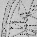
 This drainage, which you’ll be hopping over occasionally, may be not be impressive now, but at one time it had the power to gouge out the ravine you’re now descending. Indeed, this is a classic remnant of glacial Lake Hitchcock. This steep, narrow cut was carved out thousands of years ago by a wandering Slade Brook as it scoured through the soft lake-bottom sediments left behind by the retreating glacial lake. You can visit several other places in Hanover that exhibit this same dramatic effect: Trout Brook trail at the Mink Brook Nature Preserve, Kendal Riverfront Park, and the Rinker-Steele Natural Area.
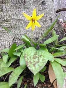 Starting at the sharp bend in the old road, you’ll be passing the Beryl Piper Little Nature Preserve on the R for the next 1/3 mile. This 3.4 acre parcel was purchased by the Town of Hanover from the Piper family in 2004. Year-round, the looming slopes of the ravine are clothed with evergreen Christmas fern, but at this time of year, ephemeral spring wildflowers may pop up among them. Most are native, but you may find the cheerful, early yellow daisy-like flowers of introduced coltsfoot, especially in disturbed areas.