Hanover Conservancy

Facebook logo   Instagram   YouTube          
Donate button
  • Home
  • About Us
    • Celebrating 60 Years
    • What We Do
      • Advocacy
      • Conservation
      • Education
      • Stewardship
    • Board & Staff
    • Membership Benefits
    • Contact Us
  • Get Outdoors
    • Hanover Lands
      • Balch Hill Natural Area
      • Mink Brook Nature Preserve
      • Other Properties
    • Hanover Hikes
    • Upper Valley Hikes
    • Exploring Nature at Home
    • Trails Challenge
    • Hunting
  • Events
    • Calendar
    • Celebrating 60 Years
    • Hanover Trails Challenge
    • Hike of the Month
    • Private Events
  • Get Involved
    • Donate
    • Volunteer
    • Adopt a Trail
    • Corporate Conservators
    • Planned Giving
  • Education
    • School Programs
      • KAST
      • Connecticut River Studies
      • Hanover High School Scholarship
    • Request a Field Trip or Speaker
    • Research on Our Lands
    • Hanover History
    • Resources
  • News
    • Remembering Bob Norman
    • Reports & e-News
  • Conserve Your Land

Behemoths of Balch Hill

August 12, 2020

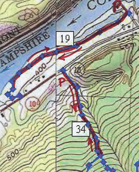
Hike Directions & Map – Full PDF

Driving directions:

  • From Downtown Hanover, drive east for 1.6Route map on Balch Hillmiles on East Wheelock Street, up a long hill to the junction of Grasse and Trescott Roads.
  • Park in the unpaved informal parking area on the northeast side of this intersection.

What you should know:

  • This loop hike takes you through the Balch Hill Natural Area to the summit with its beautiful views. Along the way you’ll visit grandfather trees that may have witnessed our town’s founding – including the Grafton County Champion Northern Red Oak.
  • You’ll be walking on lands owned by Dartmouth College, the Hanover Conservancy, and the Town of Hanover. Conservation easements and other restrictions protect some but not all of this land.
  • Trails have occasional short up-and-down grades but are easy for the entire family.
  • Foot travel only; no bicycles please.
  • Archery hunting for deer is permitted Sept 15 through Dec. 15; blaze orange is a good wardrobe choice.
  • Dogs are welcome but must be under your control; please pick up after your pet.

BRIEF HIKING DIRECTIONS

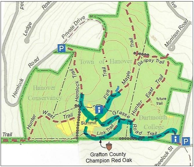
  • Take the red-blazed Grasse Road Trail from the trailhead kiosk to the summit, crossing a small footbridge.
  • From the summit kiosk, take the Fire Trail down to the junction with the Maple Trail.
  • Return to the summit and take the Hemlock Trail down to a large fallen tree.
  • Return to the summit and head for a group of apple trees and a stone bench. Look for the Piane Trail sign and turn L onto the red-blazed Grasse Road Loop.
  • Take this trail to the Champion Red Oak; continue to the small footbridge and turn R to return to your car.

FULL DIRECTIONS

  • Begin your hike at the trailhead kiosk, across Grasse Road from the parking area. The Hanover Lions Club generously donated this timber frame kiosk in 2011. Here, you can read a bit about the history of this land and pick up a trail guide if you wish.
  • The Grasse Road Trail heads across the slope on Dartmouth College land. This section was re-routed in 2015 by an Upper Valley Trails crew to follow a gentler, more sustainable path than the original.
  • The path soon turns to avoid a series of downed trees. What happened here? A short but violent windstorm on Patriot’s Day in April, 2007 blew down many trees on this part of the hill, and it will be years before they degrade back into the earth.
  • For several years near this spot stood a deer “exclosure” where Dartmouth ecology students conducted a study  to determine the effect of deer browse on the vegetation. Two identical plots, one fenced against deer and the other unfenced, were compared each year. Here are the results for the plot in this area. The blue ba
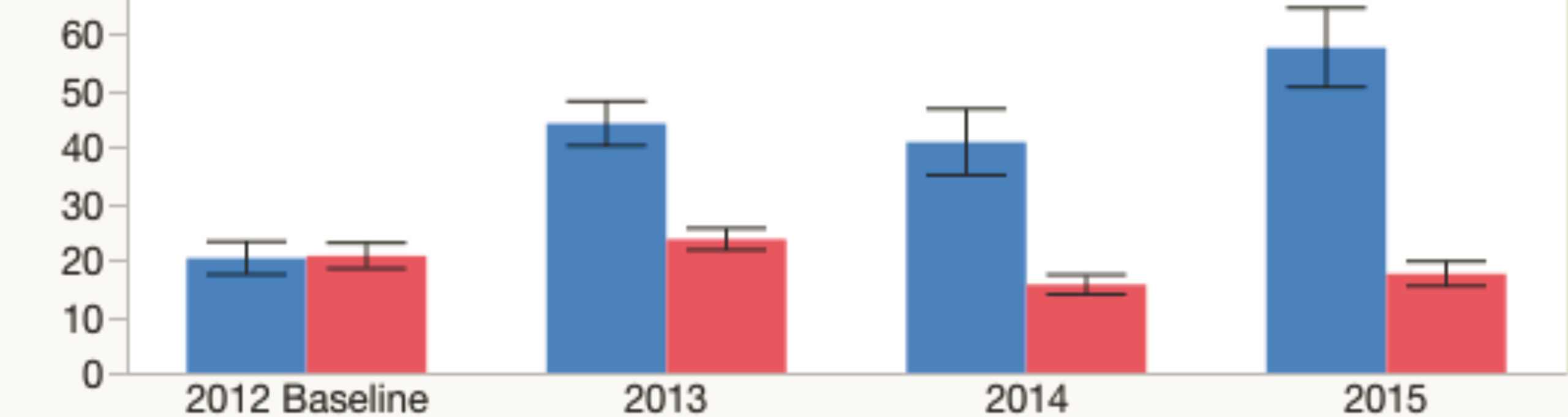
rs indicate total number of plants in the fenced plots where deer cannot enter to browse, while red bars indicate the number of plants in the unfenced plots. In 2012, before the fencing went up, both plots had nearly the same number of plants. Contrast that to 2015! The largest change is in the number of wildflowers, especially Canada mayflower.
  • You’ve reached the low stone wall marking the southern boundary. Look for fragments of sheep fencing (large rectangles of wire fence) that date from the pre-Civil War “sheep craze” in the Upper Valley. In 1840, Hanover had over 10,000 sheep grazing on its hillsides, including this one, while the human population was around 2,000.
  • Follow the Grasse Road Trail as it makes a right turn away from the wall and heads north among tall, cool hemlocks.
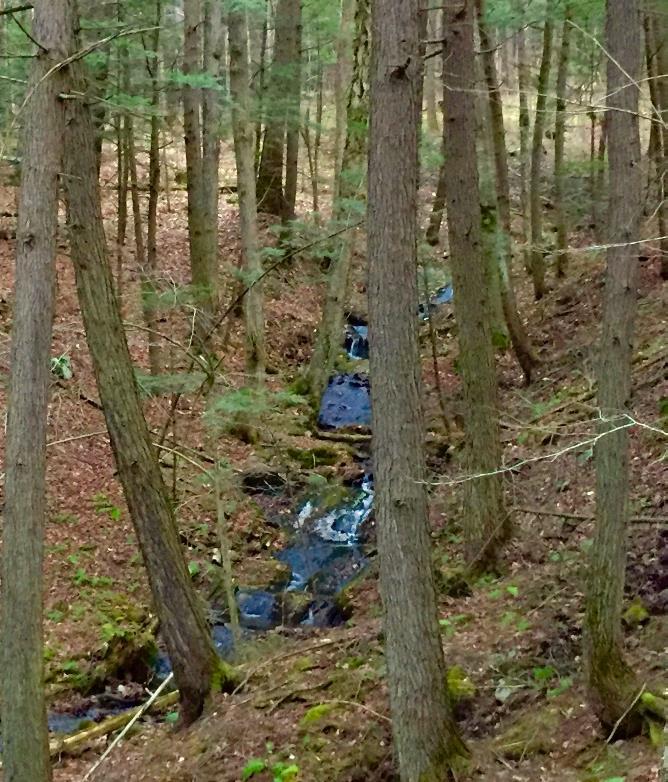
  • At the junction with the Hunter East Trail (route to the Morrison Road neighborhood), turn left and cross a small log bridge over a wet area and onto Hanover Conservancy land.

Balch Hill sunset in winter. Photo by Rob Chapman

  • The trail bears right then immediately left and heads up the slope past some dramatic pine snags. In ten minutes’ walk from your car, you’ll reach the 920’ summit.
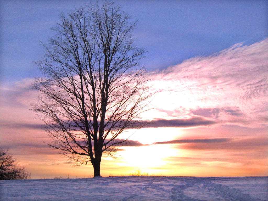
  • Enjoy the sweeping views from this, the only open summit in town where the public is welcome. Twenty-one miles to the south is grand Mount Ascutney. The spire of Baker Tower marks downtown Hanover in the near view to the west, while on the western horizon, 29 miles across Vermont, the sharp peak of Killington appears. To the northwest, our volunteers have been restoring the view toward Gile Mountain in Norwich.
  • Historically, the summit of Balch Hill was used as a pasture for grazing sheep and cattle. Records indicate that it was cleared of most trees for more than a century. In our experience, those trees badly want to return! We’ve been working to restore the orchard on the hill and keep the views open by mowing the meadow.
View of Hanover from Balch Hill in winter; undated photo
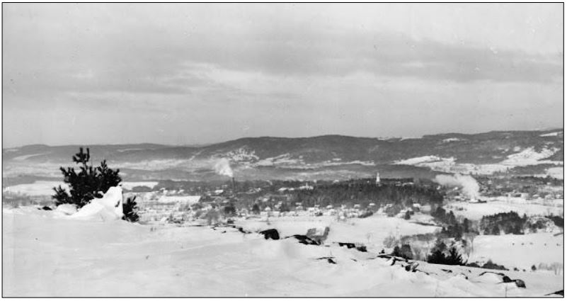
  • Once known as Corey Hill after an early owner, Balch Hill takes its name from former owner Adna P. Balch (1817-1889). Balch, a prominent citizen who served in the legislature in 1876-1877, promoted the development of the railroad in the Connecticut River Valley and was a director of the Hanover Gas Company. In the early to mid-twentieth century, the summit was known as Dewey Hill Pasture, after owners in those later days.
  • You can imagine what demand there might be to develop this hillside with its astounding views, so close to town. That’s why the Hanover Conservancy, then known as the Hanover Conservation Council, set out to purchase the summit when a New York developer proposed first 126 condominiums and then 49 luxury homes for this place. The community came together to protect the land, with the Council and Town later adding to it with a second purchase from the Garipay family. Make a note to come back for the annual Balch Hill Kite Day in May or the Hawk Watch in September, to see how much the community enjoys this natural area today. It was worth the effort!
  • After visiting the summit kiosk, erected by the Council in memory of Alice Jackson in 2009, begin your tour of Balch Hill’s biggest trees. Take the wide Fire Trail behind the kiosk for a short distance to its junction with the Maple Trail.
  • Take this right turn and in just a few steps you meet some venerable old sugar maples that may once have marked the path of an early road. These ancients stand out against their much younger brethren.
  • A person stands underneath a huge oak tree with one fallen limb
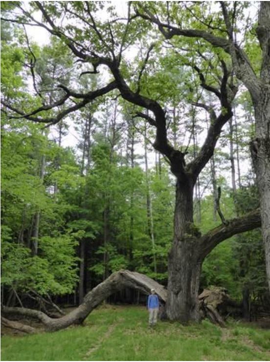
Head back up the Maple and Fire Trails to the summit. Pass the kiosk and nearby bench, and head down to the right toward the Hemlock Trail sign. You’ll soon come to the remains of an enormous old oak tree, its split trunk and massive limbs now draped across the landscape, having lost their battle with gravity and time. The trail actually passes under the fallen trunk. Here’s what it looked like in 2014 (right).
  • Return to the summit for your last view before visiting the largest resident of Balch Hill. From the low bench near the summit maple, walk west and downhill toward the view of downtown, to another stone bench near a group of crabapple trees. Just beyond, you’ll see a sign for the Piane and Grasse Rd Loop Trails on the left, nailed to a white birch. Head down this trail only a few steps and make a sharp left onto the red-blazed Grasse Rd Loop.
  • The Grasse Rd Loop trail follows the contour, leading you in a couple of minutes to the County Champion Northern Red Oak, marked with a small sign. Despite its size, it can be easy to miss as its bulk is so far overhead. Look for it opposite the cut trunk of a tree.
  • Neighbors are sometimes reluctant to cut trees along boundaries, and we think it was this instinct that protected this massive tree, the largest survivor of its kind in Grafton County. When measured by the state’s Big Tree Steward in 2014, it had a circumference of 196 inches, a height of 114 feet, and an average crown spread of 80 feet. Had its cousin on the Hemlock Trail not lost its limbs, that tree would have been even larger.
  • After admiring this giant and imagining the history it must have witnessed, continue on the trail that soon bears left to head up a small valley to the small footbridge you crossed earlier. You’re now five minutes from your car.
  • Cross the bridge, bear right at the junction with the Hunter East Trail, and return down the hill to your car.

The volunteer Balch Hill Stewardship Committee cares for thisVolunteers tend a fire to remove cut brush on the summit of Balch Hill in winter. 
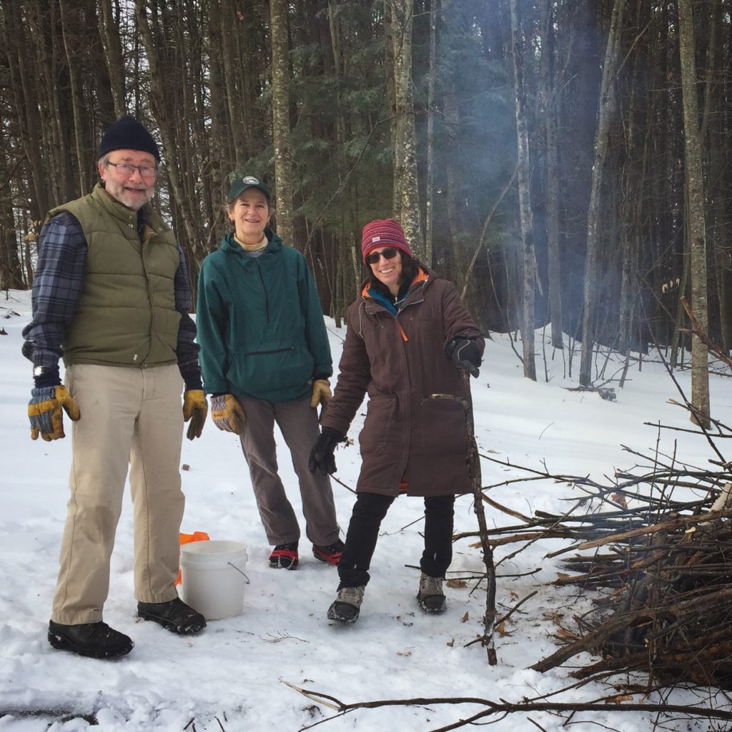
place and always welcomes help. Contact us if you’d like to get involved! We welcome contributions to the Balch Hill Stewardship Fund to help with the costs of annual mowing, vegetation management, and trail improvements.

December 2016, updated September 2020

Filed Under: Balch Hill, December, Forest Ecology, Hike of the Month Tagged With: Dartmouth College, history, maple, oak, summit, Town of Hanover, view

Fullington Farm & Old Highway 34

December 1, 2017

Hike Directions and Trail Map – Full PDF


Fullington Farm hike mapDriving Directions

  • From Downtown Hanover, drive N on N. Park Street and turn R onto Route 10N.
  • Drive past the golf course, through a rotary, past the Richmond School, and through a smaller rotary.
  • Continue 1.5 miles past the smaller rotary on Route 10 and turn L at the entrance for Wilson’s Landing.
  • Park in the gravel-surfaced lot next to the Connecticut River. Sunset is an especially lovely time for a walk on the river path, but give yourself plenty of daylight if you plan to hike Old Highway 34.

What You Should Know

  • You can opt to explore just the gentle path along the river, the more challenging Old Highway 34, or both to get a fuller sense of the variable character of Hanover’s Connecticut River corridor.
  • You’ll be walking on lands owned by the Town of Hanover, Friends of Hanover Crew (briefly) and Dartmouth College. Conservation easements protect some but not all of this land.
  • Dogs are welcome but must be under your control; please pick up after your pet. You will need a leash.

Hiking Directions – Fullington Farm River Path

  • Begin at Wilson’s Landing. This town-owned public river access area is named for Wilson Fullington, one of a family of riverfront farmers who worked this fertile land with its ample gambrel dairy barn. That property and 2.4 acres of land are now owned by the Friends of Hanover Crew.
  • Before starting your hike, walk to the water’s edge. From here, you enjoy a splendid view up the mighty Connecticut, the largest river in New England. This area is the scene of many regional crew races on the flat water impounded by Wilder Dam, a few miles downstream. When leaves are off the trees, flat-topped Smarts Mountain in Lyme appears on the horizon to the N. The Hanover Conservation Commission recently led an extensive effort to improve the public boat landing here, adding picnic tables, comfortable benches, a dock, improved boat launch, and timber-framed information kiosk.
  • The flooding of this area by Wilder Dam in 1950 changed the shoreline, and this is a great place to look for waterfowl in the quiet backwater and for smaller birds nesting in the shrubby growth nearby. At this season the slender cattails are dispersing their seeds and look like they’re wearing shaggy fleece coats. You can admire the festive scarlet twigs of red osier dogwood – there’s a good clump next to the boat landing. This native New England shrub, which grows well in wet places, is highly valued by wildlife for its nutritious white berries. You won’t see those because they don’t last long!
  • Leave your car and walk back up the gravel drive as far as the sign at R indicating that this land is protected by the Land Conservation Investment Program and the Trust for NH Lands. This was New Hampshire’s first venture into conservation on a state-wide scale, authorized by the Legislature in 1987, which appropriated $25 million that was spent (with $3.3 million of private funds) to protect over 100,000 acres of much appreciated land before the program closed in 1993. The Huntington Hill lands nearby in Hanover were also protected through this program. The Hanover Conservancy, then known as the Hanover Conservation Council, led a fund-raising campaign for the local match. The land remains privately owned but is now protected by a permanent conservation easement held by the Town.
  • merganser in flightEnough talk, let’s walk! Turn R off the drive and onto the mown path just before the gravel path leading to the crew boathouse. Turn S along the river. For the next few minutes you’ll have a good view of the backwater, where dabbling ducks and other waterfowl shelter in this quiet area off the mainstem, especially during the fall migration. The Connecticut River is a major migration corridor for these and other birds. On the afternoon we walked this path, the lowering sun lit the white breast of a migrating common merganser, its rapid wingbeats echoing the intent of its outstretched neck as it flew south, low and fast, over the water. (R – male in flight)
  • Meadowsweet, goldenrod, and other rough herbs and shrubs grow near the bank, along with sumac, red and silver maple. This riparian buffer helps capture any sediment in the runoff from the fields that might be headed toward the river. Common among them is invasive honeysuckle, easily picked out with its scrappy bark, low arching branches, and opposite buds. This shrub is especially obvious around the gullies and cavities in the bank at the bottom of the field.
  • About 8 minutes into your walk, pass through a gap in a hedgerow marking the boundary of a larger field. You’re in a world apart – while you can hear the sounds of cars on Route 10 above and Route 5 across the river, your view is much more wholesome – all rolling fields and river. The rich soils under the sod, a gift of the river, are among the most fertile in the country. Indeed, they are among the most valuable agricultural soils in Hanover.
  • The mown path curves R around a gully; glance to the N for a nice view of Smarts Mountain and the point of wet land extending downstream from Wilson’s Landing (when leaves are off the trees).
  • Soon the big white barn of the Dartmouth Organic Farm comes into view above at L, along with the low building now housing the Hampshire Cooperative Nursery School. These are the current uses of what was the last dairy farm of any significance in Hanover – the Dartmouth Dairy, also known as the Fullington Farm. Four generations of Fullingtons worked this land, most recently with a milk processing and bottling plant run by Haslett Fullington and his brother, Wilson. Their fleet of trucks delivered milk produced by their herd of Guernseys to the college and beyond. Dartmouth bought the property in 1972.
  • 1892 Fullington area map
    1892 map of the area

    The Fullingtons had been on the land since at least 1860, and lived in the c. 1820 cape house that stood near the large and handsome early barn. In 1885, the Grafton County Gazetteer listed William Fullington as farming 220 acres with 300 head of registered Merino sheep and a sugarbush of 120 maples. The College tore down the nearly 200-year-old farmhouse in the summer of 2017. (R- 1892 map of the area)

  • Today, your path passes an experimental planting area, bee hives, and a nursery of evergreen and deciduous trees on the fields where the Fullingtons once grew feed for their cows or pastured their sheep. The path approaches the south boundary where a gravel drive curves up to Route 10. You can walk back to your car along the road, but it’s more fun to retrace your steps and head north on the mown path along the river.
  • As you do, note the sole many-stemmed tree standing nearby on the riverbank, a sole representative of the grand and towering silver maple floodplain forest that once blanketed the riverbottom here – after the glacier left but before European settlers cleared the alluvial plains for farming, before the Smiths and Fullingtons, and before Wilder Dam inundated the shoreline. Silver maples tolerate flooding and are supremely adapted to such a setting.
  • As you return N, the pine-studded crest of an esker looms beyond the barn roof. This is part of a ribbon of sand left behind by melting water under the glacier as it covered this area thousands of years ago. You can explore another piece of this geological ribbon at the South Esker (Hanover Hike of the Month, August).
  • The low sun of the approaching winter plays tricks as you walk N along the river. Your shadow reaches forty feet ahead and the light reflects off the river, illuminating golden brown oak leaves still clinging to their branches. Oaks are thought to have evolved in the south and never developed the knack of dropping their leaves in fall as those of northern maples and birches do.
  • Pass through the hedgerow and enjoy a fine view of the beautiful white dairy barn.
  • It appears that both the old farms you pass on this walk have been present for centuries – no surprise given their desirable soils. Just north of the barn, a fine two-story farmhouse stood from 1771 until it was torn down in 2018. Historic maps indicate that this riverfront farm was occupied by one I. Smith in 1855 (when the Fullington Farm was owned by a B. Tisdale), and in 1892 by F. W. Smith. We’re guessing that the Fullingtons bought their neighbors’ place sometime around 1910 to make room for a son and his family, updating the old Smith farmhouse with a generous front porch.
  • Turn L toward the boat landing and back to your car. Resolve to return for a family picnic by the river!

Hiking Directions – Old Highway 34

  • If you have another half hour and energy to spare, cap off your adventure with another hike into the past. If it is hunting season, you’ll want to dress in fashion – blaze orange.
  • You can either walk or drive to the nearby trailhead. Return to Route 10, turn R and then L up a short gravel drive. This leads to an unmarked parking area N of the flat old river terrace that today sees less action from glacial Lake Hitchcock and more from soccer players. In winter, trucks deliver snow plowed from downtown streets to this spot, allowing it to melt into the ground close to the river where any contaminants mixed with the snow cannot interfere with drinking water wells or the river directly.
  • Walk around the green metal gate across the entrance to the old road. In 1794, Highway 34 ran “from Ezra Carpenter’s on the Wolfeboro Road to Elias Newton’s on the River Road” (meaning Route 10). Its S end continues as Grasse Road linking Reservoir Road to Trescott Road. In 1979, Town Meeting voted to discontinue the N part subject to gates and bars such as this one. The Town still owns the right of way.
  • You’ll soon reach signs indicating the college’s shooting range; the old road probably passed through that area. Instead, you will turn R, away from the range, and skirt the L edge of the field, hiking uphill. The college’s sugarhouse is visible at R. Does the sap from William Fullington’s 120 maples boil there?
  • When the nursery school is in session, this area becomes an outdoor classroom. It looks like fun!
  • unnamed brook in Fullington areaNo more than 5 minutes from the gate, the narrow historic road becomes evident again, passing straight up into the woods. It climbs steadily on the R side of a narrow little valley, heavily wooded with large hemlocks and white pine. One can only imagine the strength required of a farm horse to draw a laden wagon up this hill. The remains of an old stone wall appear at R, confirming the nature of the old way. An unnamed stream tumbles down the hillside at L through a shaded and undisturbed valley. It’s the clear waters of small, cool, well-oxygenated streams like this that provide relief for fish in the Connecticut River below.
  • 10 minutes from the lower gate, you’ll reach another one. This is your turnaround point today. Pause to note a lovely small waterfall at L (photo). At R is undeniable evidence that the forest beyond was once the Fullingtons’ diligently maintained pasture – many strands of barbed wire still attached to the stump of a long-dead tree.
  • At this point, Highway 34 bears gently R and enters a maze of trails on Oak Hill before it ends at Reservoir Road, 1.8 miles from your starting point. That’s a challenge for another day.
  • Return to your car, enjoying the gentle conversation of the brook and wondering, as we do, why it never earned a proper name. We think it should be Fullington Brook.

December 2017, updated August 2020

Filed Under: December, Hike of the Month Tagged With: Class VI Road, Fullington Farm, Highway 34, merganser

Thank you for your support!

Our generous members and Corporate Conservators help make all of this possible. If you’re a customer of  our local business supporters, please let them know their contributions are appreciated!

71 Lyme Road
Hanover, NH 03755
(603) 643-3433

info@hanoverconservancy.org

Facebook logo   Instagram   YouTube

Get Involved

Become a Member

Volunteer

Business Sponsors

Conserve Your Land

Employment

Our Mission

Advocacy

Conservation

Education

Stewardship

Explore Hanover

Hanover Hikes

Upcoming Events

Upper Valley Hikes

Trails Challenge

Copyright © 2023 Hanover Conservancy | Design by Chase Brook Software