Hanover Conservancy

Facebook logo   Instagram   YouTube          
Donate button
  • Home
  • About Us
    • Celebrating 60 Years
    • What We Do
      • Advocacy
      • Conservation
      • Education
      • Stewardship
    • Board & Staff
    • Membership Benefits
    • Contact Us
  • Get Outdoors
    • Hanover Lands
      • Balch Hill Natural Area
      • Mink Brook Nature Preserve
      • Other Properties
    • Hanover Hikes
    • Hanover Trails Challenge
    • Upper Valley Hikes
    • Exploring Nature at Home
    • Hunting
  • Events
    • Calendar
    • Spring Wildflower Scavenger Hunt
    • Private Events
  • Get Involved
    • Donate
    • Volunteer
    • Adopt a Trail
    • Corporate Conservators
    • Planned Giving
  • Education
    • School Programs
      • KAST
      • Connecticut River Studies
      • Hanover High School Scholarship
    • Request a Field Trip or Speaker
    • Research on Our Lands
    • Hanover History
    • Resources
  • News
    • Remembering Bob Norman
    • Reports & e-News
  • Conserve Your Land

Corey Road and the AT

March 1, 2018

Corey Road & the AT – full PDF

Corey Road and AT hike mapDriving Directions

  • From Etna village, turn R onto Ruddsboro Road
  • Follow Mink Brook as the road curves up its narrow valley for 1.5 miles
  • Turn L onto Three Mile Road
  • After 1.2 miles, arrive at the AT parking area on L opposite telephone pole 31-50 (if parking area is not plowed, park on shoulder)
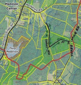
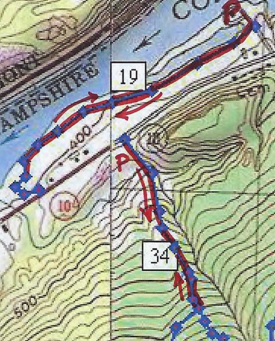
  • Today’s out-and-back hike, shown on the map at R, takes you to two fascinating historic sites.

What You Should Know

  • In winter, we suggest hiking poles and micro-spikes or snowshoes for traction, especially for the brook crossings. If rising temperatures threaten to melt snow/ice cover on the AT, we strongly advise taking your hike in the morning while surfaces are still frozen, to protect the treadway. Corey Road can be wet if snow cover has melted, and boots are advised.
  • You’re about to visit lands owned by the federal government (permanently protected) and a small portion of private land protected for AT corridor. Corey Road is a Class VI road open to the public subject to gates and bars.
  • The Corey Road portion of this hike makes for great skiing. If you’d rather do that, enter Corey Road at its south end, at the junction of Three Mile, Old Dana, and Chandler Roads. Park with respect for the private residence at the historic cape here; walk up the driveway and through the gate to continue on the Class VI portion of this road.
  • If you can’t bear to stop, you can combine this hike with a one-hour loop on the E side of Three Mile Road, posted as the February Hike of the Month: Mink Brook & the Harris Trail.
  • Dogs are welcome if under your control; please pick up after your pet.

Brief Directions

  • Take the AT westbound from Three Mile Road for about 15 minutes to Corey Road.
  • Turn R and follow Corey Road for about 20 minutes to an historic stone bridge.
  • Return the way you came.

Full Hiking Directions

  • Begin your hike at the wooden AT sign set back from Three Mile Road and proceed gently downhill through a young mixed forest of pine and northern hardwoods. Here and there, the gleaming bark of yellow birch catches the sun.
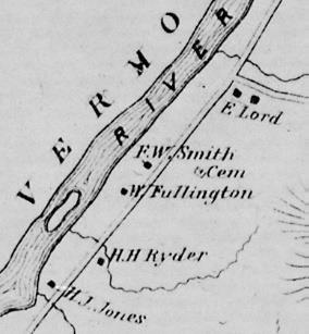
  • The 1855 and 1892 maps show no homes on this side of Three Mile Road between Chandler and the Wolfeboro Road, and so it was likely that most of this land served as sheep pasture then.
  • turkey prints on the snow
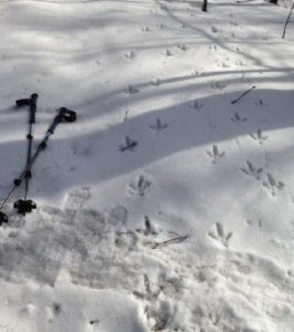
    We missed the turkey parade!

    If snow conditions are right, you can mark the passage of many creatures in these woods. Red squirrels, deer, and turkey are the most obvious.

  • Begin your hike at the wooden AT sign set back from Three Mile Rd and proceed gently downhill through a young mixed forest of pine and northern hardwoods. Here and there, the gleaming bark of yellow birch catches the sun.
  • The 1855 and 1892 maps show no homes on this side of Three Mile Rd between Chandler and the Wolfeboro Rd, and so it was likely that most of this land served as sheep pasture then.
  • If snow conditions are right, you can mark the passage of many creatures in these woods. Red squirrels, deer, and turkey are the most obvious.
  • 8 minutes’ walk from your car, you encounter the remains of an ancient tree that split like a giant lily at its base. Three large trunks fell at R, and another to the L was cleared away.
  • 5 minutes further, some kind soul has placed rough planks to help you cross a series of small rivulets. Send silent thanks to the dedicated trail maintainer of this section of the AT (we know who he is!) for keeping your feet dry.
  • The largest of these brooks marks a transition to larger pine, and you note five blowdowns at L. Their fallen boles all lie SW of their tipped up root systems, hinting that a nor’easter took them down. As the years pass their root masses will decay, leaving only the mounds and pits we find all over New England forests that speak softly but eloquently of such forest disturbances.
  • Corey Road wooden trail sign
    Corey Road

    Soon you reach a stone wall lined with large sugar maples, signaling your arrival at Corey Road. A close look at L reveals strands of barbed wire caught in the wood of one old tree, still on duty to keep the cows out of traffic.

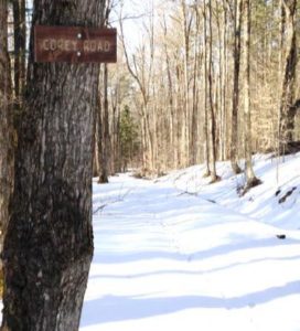
  • From the center of the road, turn completely around to note two wooden signs placed (thank you, Hanover Trails Committee volunteers!) to identify the historic road. You’ll want to keep an eye out for them on your return trip.
  • Corey Road was laid out and surveyed on November 14, 1793 from the Wolfeboro Rd S to Chandler Rd, and was once an important link between Hanover Center and Enfield. One house stood on the road in 1855, but it was gone by 1892. By 1948, Corey Road was in disuse and Town Meeting voted to discontinue it subject to gates and bars. The AT was busier – Dr. Goldthwait noted a crossing of “the D.O.C. trail to Moose Mountain” when mapping the area in 1926.
  • Turn R and head N down Corey Rd. Stone walls line both sides. As you proceed, some sections of the R wall are composed of much smaller stones than elsewhere, hinting that the ground nearby may once have been tilled. This more intensive use would have motivated the landowner to remove smaller stones that could damage a plow, and dispose of them in the wall.
  • 6 minutes from the AT junction, you’ll head down a short, steeper pitch toward a brook – the same one you crossed on the AT. A formidable stone foundation appears at L on the other side. Stone walls and barbed wire mark boundaries.
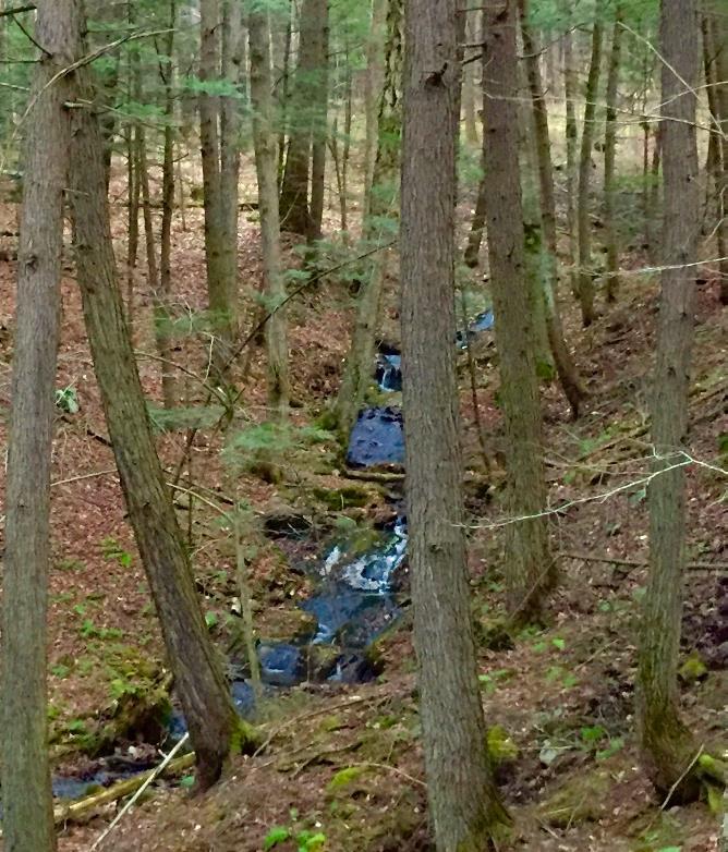
  • Cross this small brook carefully. The size of woody debris caught just below indicates that this brook can punch above its apparent weight during a heavy rain.
  • dog on cellar hole stones
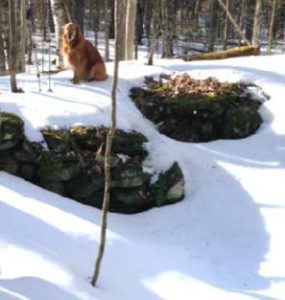
    Corey-Woodard cellar hole

    Hike back up a few yards beyond the brook and past the stone foundation. Just as you reach more level ground, step off the road to discover a cellar hole, about 20 paces to the L. Likely the original Corey homestead, it was the home of one O. Woodard by 1855. The cellar hole is lined by a drylaid stone foundation. If it seems too small, consider that a cellar was needed under only a part of the home, and a glance to the N reveals a flat rectangular area where the rest of the house stood. Sited just above the road with SW exposure for solar gain and a good water source close by, this must have been a fine place to live. What happened to prompt its abandonment by the 1890s? We don’t know.

  • After exploring the cellar hole, return to Corey Road and continue N. Here, the stone wall at R is composed of coarse boulders topped with barbed wire – the edge of a pasture, not a garden.
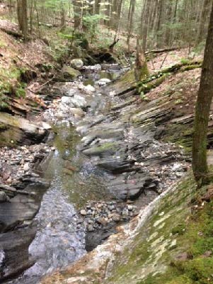
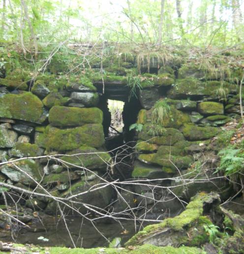
  • 7 minutes after leaving the cellar hole, you arrive at a second brook crossing, this time forded with the most impressive surviving drylaid stone culvert in Hanover.  Walk down to
    Corey Road culvert
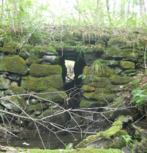
    Corey Road stone culvert (fall 2012)

    the L on the S side to get a good view up to the moss-covered structure that has lasted here for 225 years. A close look reveals a flat stone lintel that carries Corey Road across the brook. The opening is tall enough to accommodate a short person. Imagine what it took to build this crossing!  Even more incredibly, the home-grown engineering created a stable bridge that has withstood not only the centuries but also – so far – the sudden, higher flows from microbursts and other heavy storms associated with climate change.

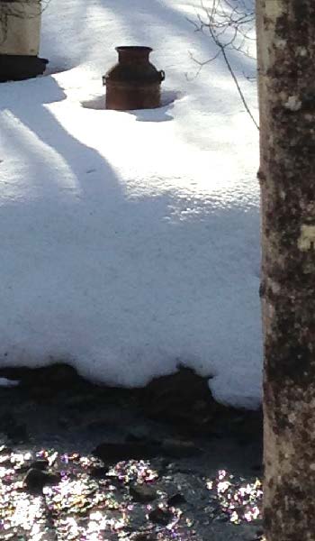
  • Bright sky appears across the brook and above to the L, indicating an open field. Below the slope and along the streambank is a collection of what can politely be called “cultural debris,” such as an old milk can. It was once common practice to toss unwanted items over a bank, often near a stream. This spot is a little open air museum thanks to that habit!
  • Like us, you’re probably tempted to linger by the bridge a bit longer, so we’ll tell you about the stream. This is Monahan Brook, the principal N tributary of Mink Brook. It rises N of Wolfeboro Road and flows SW to the Third Reservoir near Hanover Center Rd. From there, much of the water is diverted from Mink Brook and piped under the road and into the woods above the Parker Reservoir in the Trescott Water Supply Lands. Then it’s a short trip to downtown kitchens and drinking fountains. You’ve been hiking through more drinking water supply lands! However, the watershed of the Third Reservoir is only minimally protected – the Town owns only a narrow strip within 175-200 yards of the water’s edge. Federal land and AT easements protect a bit more, as do two privately conserved parcels at Monahan Brook’s headwaters, but otherwise this watershed is protected only by the good will of private landowners.
  • Monahan Brook and the rest of the Mink Brook watershed were part of a statewide study by Trout Unlimited and NH Fish and Game biologists in 2011, assisted by the Hanover Conservancy. They found that “Hanover’s little Mink Brook and its tributaries showed a surprisingly healthy population of native Eastern Brook Trout.” You are now standing at one of those study sites.
  • Corey Rd continues as a Class VI Road up to Wolfeboro Rd, but today we’ll retrace our steps and head S.
  • 9 minutes’ walk brings you back to the first brook, where several channels join upstream of your crossing. Make a note of the time.
  • Step over the brook and continue a gentle but steady uphill walk for about 8 minutes. Even under the snow, you can see the depression of the old road bed even though it has not been traveled for at least 70 years. Keep an eye out for the Corey Road sign at the AT crossing.
  • Reach the AT and stop to listen to the sighing pines overhead, imagining the open sunny pastures that once flanked the road on both sides, shaded only by the old maples lining the stone walls.
  • Turn L onto the AT and head E toward Three Mile Rd (and ultimately, N to Maine!).
  • 15 minutes’ hike on the gently rising trail will bring you back to your car.
  • A reminder – if you can’t bear to stop, you can combine this hike with a one-hour loop on the E side of Three Mile Road, the February Hike of the Month: Mink Brook and the Harris Trail.

sap buckets in snow

March  2018, revised July 2020

Filed Under: Hike of the Month, March Tagged With: Appalachian Trail, cellar hole, Class VI Road, Wolfeboro Road

Fullington Farm & Old Highway 34

December 1, 2017

Hike Directions and Trail Map – Full PDF


Fullington Farm hike mapDriving Directions

  • From Downtown Hanover, drive N on N. Park Street and turn R onto Route 10N.
  • Drive past the golf course, through a rotary, past the Richmond School, and through a smaller rotary.
  • Continue 1.5 miles past the smaller rotary on Route 10 and turn L at the entrance for Wilson’s Landing.
  • Park in the gravel-surfaced lot next to the Connecticut River. Sunset is an especially lovely time for a walk on the river path, but give yourself plenty of daylight if you plan to hike Old Highway 34.

What You Should Know

  • You can opt to explore just the gentle path along the river, the more challenging Old Highway 34, or both to get a fuller sense of the variable character of Hanover’s Connecticut River corridor.
  • You’ll be walking on lands owned by the Town of Hanover, Friends of Hanover Crew (briefly) and Dartmouth College. Conservation easements protect some but not all of this land.
  • Dogs are welcome but must be under your control; please pick up after your pet. You will need a leash.

Hiking Directions – Fullington Farm River Path

  • Begin at Wilson’s Landing. This town-owned public river access area is named for Wilson Fullington, one of a family of riverfront farmers who worked this fertile land with its ample gambrel dairy barn. That property and 2.4 acres of land are now owned by the Friends of Hanover Crew.
  • Before starting your hike, walk to the water’s edge. From here, you enjoy a splendid view up the mighty Connecticut, the largest river in New England. This area is the scene of many regional crew races on the flat water impounded by Wilder Dam, a few miles downstream. When leaves are off the trees, flat-topped Smarts Mountain in Lyme appears on the horizon to the N. The Hanover Conservation Commission recently led an extensive effort to improve the public boat landing here, adding picnic tables, comfortable benches, a dock, improved boat launch, and timber-framed information kiosk.
  • The flooding of this area by Wilder Dam in 1950 changed the shoreline, and this is a great place to look for waterfowl in the quiet backwater and for smaller birds nesting in the shrubby growth nearby. At this season the slender cattails are dispersing their seeds and look like they’re wearing shaggy fleece coats. You can admire the festive scarlet twigs of red osier dogwood – there’s a good clump next to the boat landing. This native New England shrub, which grows well in wet places, is highly valued by wildlife for its nutritious white berries. You won’t see those because they don’t last long!
  • Leave your car and walk back up the gravel drive as far as the sign at R indicating that this land is protected by the Land Conservation Investment Program and the Trust for NH Lands. This was New Hampshire’s first venture into conservation on a state-wide scale, authorized by the Legislature in 1987, which appropriated $25 million that was spent (with $3.3 million of private funds) to protect over 100,000 acres of much appreciated land before the program closed in 1993. The Huntington Hill lands nearby in Hanover were also protected through this program. The Hanover Conservancy, then known as the Hanover Conservation Council, led a fund-raising campaign for the local match. The land remains privately owned but is now protected by a permanent conservation easement held by the Town.
  • merganser in flightEnough talk, let’s walk! Turn R off the drive and onto the mown path just before the gravel path leading to the crew boathouse. Turn S along the river. For the next few minutes you’ll have a good view of the backwater, where dabbling ducks and other waterfowl shelter in this quiet area off the mainstem, especially during the fall migration. The Connecticut River is a major migration corridor for these and other birds. On the afternoon we walked this path, the lowering sun lit the white breast of a migrating common merganser, its rapid wingbeats echoing the intent of its outstretched neck as it flew south, low and fast, over the water. (R – male in flight)
  • Meadowsweet, goldenrod, and other rough herbs and shrubs grow near the bank, along with sumac, red and silver maple. This riparian buffer helps capture any sediment in the runoff from the fields that might be headed toward the river. Common among them is invasive honeysuckle, easily picked out with its scrappy bark, low arching branches, and opposite buds. This shrub is especially obvious around the gullies and cavities in the bank at the bottom of the field.
  • About 8 minutes into your walk, pass through a gap in a hedgerow marking the boundary of a larger field. You’re in a world apart – while you can hear the sounds of cars on Route 10 above and Route 5 across the river, your view is much more wholesome – all rolling fields and river. The rich soils under the sod, a gift of the river, are among the most fertile in the country. Indeed, they are among the most valuable agricultural soils in Hanover.
  • The mown path curves R around a gully; glance to the N for a nice view of Smarts Mountain and the point of wet land extending downstream from Wilson’s Landing (when leaves are off the trees).
  • Soon the big white barn of the Dartmouth Organic Farm comes into view above at L, along with the low building now housing the Hampshire Cooperative Nursery School. These are the current uses of what was the last dairy farm of any significance in Hanover – the Dartmouth Dairy, also known as the Fullington Farm. Four generations of Fullingtons worked this land, most recently with a milk processing and bottling plant run by Haslett Fullington and his brother, Wilson. Their fleet of trucks delivered milk produced by their herd of Guernseys to the college and beyond. Dartmouth bought the property in 1972.
  • 1892 Fullington area map
    1892 map of the area

    The Fullingtons had been on the land since at least 1860, and lived in the c. 1820 cape house that stood near the large and handsome early barn. In 1885, the Grafton County Gazetteer listed William Fullington as farming 220 acres with 300 head of registered Merino sheep and a sugarbush of 120 maples. The College tore down the nearly 200-year-old farmhouse in the summer of 2017. (R- 1892 map of the area)

  • Today, your path passes an experimental planting area, bee hives, and a nursery of evergreen and deciduous trees on the fields where the Fullingtons once grew feed for their cows or pastured their sheep. The path approaches the south boundary where a gravel drive curves up to Route 10. You can walk back to your car along the road, but it’s more fun to retrace your steps and head north on the mown path along the river.
  • As you do, note the sole many-stemmed tree standing nearby on the riverbank, a sole representative of the grand and towering silver maple floodplain forest that once blanketed the riverbottom here – after the glacier left but before European settlers cleared the alluvial plains for farming, before the Smiths and Fullingtons, and before Wilder Dam inundated the shoreline. Silver maples tolerate flooding and are supremely adapted to such a setting.
  • As you return N, the pine-studded crest of an esker looms beyond the barn roof. This is part of a ribbon of sand left behind by melting water under the glacier as it covered this area thousands of years ago. You can explore another piece of this geological ribbon at the South Esker (Hanover Hike of the Month, August).
  • The low sun of the approaching winter plays tricks as you walk N along the river. Your shadow reaches forty feet ahead and the light reflects off the river, illuminating golden brown oak leaves still clinging to their branches. Oaks are thought to have evolved in the south and never developed the knack of dropping their leaves in fall as those of northern maples and birches do.
  • Pass through the hedgerow and enjoy a fine view of the beautiful white dairy barn.
  • It appears that both the old farms you pass on this walk have been present for centuries – no surprise given their desirable soils. Just north of the barn, a fine two-story farmhouse stood from 1771 until it was torn down in 2018. Historic maps indicate that this riverfront farm was occupied by one I. Smith in 1855 (when the Fullington Farm was owned by a B. Tisdale), and in 1892 by F. W. Smith. We’re guessing that the Fullingtons bought their neighbors’ place sometime around 1910 to make room for a son and his family, updating the old Smith farmhouse with a generous front porch.
  • Turn L toward the boat landing and back to your car. Resolve to return for a family picnic by the river!

Hiking Directions – Old Highway 34

  • If you have another half hour and energy to spare, cap off your adventure with another hike into the past. If it is hunting season, you’ll want to dress in fashion – blaze orange.
  • You can either walk or drive to the nearby trailhead. Return to Route 10, turn R and then L up a short gravel drive. This leads to an unmarked parking area N of the flat old river terrace that today sees less action from glacial Lake Hitchcock and more from soccer players. In winter, trucks deliver snow plowed from downtown streets to this spot, allowing it to melt into the ground close to the river where any contaminants mixed with the snow cannot interfere with drinking water wells or the river directly.
  • Walk around the green metal gate across the entrance to the old road. In 1794, Highway 34 ran “from Ezra Carpenter’s on the Wolfeboro Road to Elias Newton’s on the River Road” (meaning Route 10). Its S end continues as Grasse Road linking Reservoir Road to Trescott Road. In 1979, Town Meeting voted to discontinue the N part subject to gates and bars such as this one. The Town still owns the right of way.
  • You’ll soon reach signs indicating the college’s shooting range; the old road probably passed through that area. Instead, you will turn R, away from the range, and skirt the L edge of the field, hiking uphill. The college’s sugarhouse is visible at R. Does the sap from William Fullington’s 120 maples boil there?
  • When the nursery school is in session, this area becomes an outdoor classroom. It looks like fun!
  • unnamed brook in Fullington areaNo more than 5 minutes from the gate, the narrow historic road becomes evident again, passing straight up into the woods. It climbs steadily on the R side of a narrow little valley, heavily wooded with large hemlocks and white pine. One can only imagine the strength required of a farm horse to draw a laden wagon up this hill. The remains of an old stone wall appear at R, confirming the nature of the old way. An unnamed stream tumbles down the hillside at L through a shaded and undisturbed valley. It’s the clear waters of small, cool, well-oxygenated streams like this that provide relief for fish in the Connecticut River below.
  • 10 minutes from the lower gate, you’ll reach another one. This is your turnaround point today. Pause to note a lovely small waterfall at L (photo). At R is undeniable evidence that the forest beyond was once the Fullingtons’ diligently maintained pasture – many strands of barbed wire still attached to the stump of a long-dead tree.
  • At this point, Highway 34 bears gently R and enters a maze of trails on Oak Hill before it ends at Reservoir Road, 1.8 miles from your starting point. That’s a challenge for another day.
  • Return to your car, enjoying the gentle conversation of the brook and wondering, as we do, why it never earned a proper name. We think it should be Fullington Brook.

December 2017, updated August 2020

Filed Under: December, Hike of the Month Tagged With: Class VI Road, Fullington Farm, Highway 34, merganser

Slade Brook Watershed Trails

September 1, 2017

Trail Description and Map – Full Hike


Slade Brook trail mapDriving Directions

  • From downtown, head N on Rt. 10 past Hanover Conservancy offices
  • Continue on Route 10, 3.3 miles past the N rotary
  • Turn R on Old Lyme Rd. and drive 0.2 miles to a sharp bend.
  • Park on R on gravel shoulder.

What You Should Know

  • Foot travel only, except for Old Spencer Road.
  • Dogs are welcome but must be under close control.
  • This loop hike passes through the Barnes Estate, owned and managed by Dartmouth Hitchcock Medical Center, before reaching the Huntington Hill Wildlife Management Area, a major privately owned parcel protected by a conservation easement held by the NH Fish and Game Department.

Hiking Directions

  • There’s a secret waiting for you right here, before you start into the woods. Walk a few dozen yards back down Old Lyme Road to the guard rail marking Slade Brook’s passage below. Look carefully on the left beyond the far end of the rail for a dramatic drylaid stone bridge abutment. This once carried the original road linking Hanover to Lyme and points north. Today, we whiz by this area at 50+mph on a much straightened, widened, and otherwise altered route. Imagine journeying to Lyme on the poky narrow road that existed before Dartmouth urged the state to “improve” travel to its new Skiway in Lyme Center.
  • Back at your car, look for two routes into the woods. At L, a woods road heads uphill, blocked with a cable. This is where you’ll return. At R, a clear, narrower level path leads in to the woods. Begin your hike here.
  • In a few yards you’ll pass over a narrow wooden footbridge, built by volunteers shortly before the Hanover Conservancy protected the Jim and Evalyn Hornig Natural Area at Lower Slade Brook, just downstream from Route 10. (2007) This crossing replaces an earlier one – look down to the left to see remains of the old stone abutment for the bridge that once carried Old Spencer Road over this stream.
  • Follow Old Spencer Road through the woods and up the hill to an upper river terrace that was once the shore of glacial Lake Hitchcock. This land is part of the former Barnes Estate, now owned by DHMC.
  • old stone wallOld Spencer Road links Old Lyme Road with Dogford Road, built in 1816 “from Benjamin Thatcher’s to the County Road.” Thatcher’s place (known today as the Nutt Farm on Dogford Road) was later owned by Captain Uel Spencer. Town Meeting voted to discontinue the road subject to gates and bars in Hanover is criss-crossed with dozens of early roads like this one, providing fine hiking, snowshoeing, horseback riding, biking, and skiing now that they are retired and no longer maintained for more intensive use.
  • About 7-8 minutes from the bridge, you’ll reach a tree down across the old road (which may be gone by the time you read this) and a junction. Old Spencer Road continues straight uphill. A logging skid trail is visible nearby at R. What appears to be another skid trail bears off Old Spencer Road at L. This is the Bridle Path, and your turn. Before taking it, continue another minute or two up the old road as it fully reveals its historic character. Partly buried stone walls mark each side and the roadbed appears sunken between them. Barbed wire follows the wall on the S side, a reminder that cattle once pastured here before the forest returned.
  • fisher
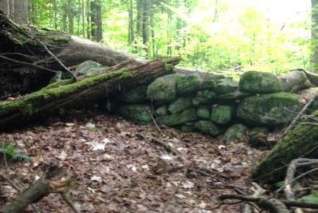
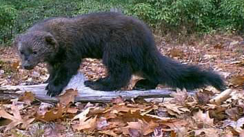
Watch for wildlife – on the day we visited, a fisher paused here on the wall to observe us. The largest member of the weasel family, the fisher is a lithe and talented predator that makes a specialty of dining on porcupine.
  • Return to the junction and take the Bridle Path that veers NE. It too has been used recently as a skid trail, but it quickly narrows and you’ll soon hear the music of Slade Brook at L.
  • After five minutes’ walk from Old Spencer Road, a new wooden bridge comes into view as you cross onto the Huntington Hill Wildlife Management Area.
  • Pause on the bridge to admire both the workmanship and the partnership that built it in May-July, 2017. A determined team of 20 volunteers, led by Hugh Mellert and the Hanover Conservation Commission’s Trails Committee, built the bridge with permission of the private landowners and help from the Upper Valley Trails Alliance, Hanover Public Works, Hanover Conservancy, Cardigan Mountain Highlanders, DHMC, neighbors, and hikers who happened by and jumped in. Funds for materials were donated and the 250 person hours of labor were free. This new bridge replaces one that’s been gone for 50 years, and provides a safe and valuable connection to the network of trails on Huntington Hill.
  • Slade BrookNow turn your attention to the brook itself, and the fascinating variety of rocks composing its bed. Water-worn granite alternates with leaves of uplifted, slanted sedimentary rock that speak volumes about the deep geological history of this place.
  • Two trails meet at the far end of the bridge. Bear L onto the wider of the two and head steadily uphill through a pine/hemlock forest. Faded pink flagging marks the route.
  • About 10 minutes’ walk from the bridge, you reach the top of a rise where the Barnes Trail comes in at L by two large white pines. Just ahead, another trail junction is visible.
  • Turn L onto the Barnes Trail and head down the narrower, pine needle- strewn path. The Barnes Trail is easy to follow as it meanders pleasantly down the slope. There’s a nice patch of foamflower (Tiarella cordifolia) on the R just before you cross a small drainage. Resolve to come back in May to see this native wildflower in bloom. The Barnes Trail begins to feel like an old woods road.
  • Cross another, larger drainage. Ten minutes’ walk from the last junction, reach a sunny opening filled with native wildflowers like Queen Anne’s Lace and various kinds of goldenrods, but with an ominous patch of Japanese knotweed. This log landing provides a valuable bit of open habitat nevertheless.
  • Continue across the clearing and re-enter the woods.
  • The trail, now an obvious logging road, passes through another small opening and then swings L and heads down to where your car awaits.

Please respect the generosity of these landowners by leaving no trace of your visit and enjoy the memories and photographs you take home.

8/30/2017

Filed Under: Hike of the Month, September, Slade Brook Tagged With: Class VI Road, fisher, foamflower

71 Lyme Road
Hanover, NH 03755
(603) 643-3433

info@hanoverconservancy.org

Facebook logo   Instagram   YouTube

Get Involved

Become a Member

Volunteer

Business Sponsors

Conserve Your Land

Employment

Our Mission

Advocacy

Conservation

Education

Stewardship

Explore Hanover

Hanover Hikes

Upcoming Events

Upper Valley Hikes

Trails Challenge

Copyright © 2025 Hanover Conservancy | Design by Chase Brook Software