Hanover Conservancy

Facebook logo   Instagram   YouTube          
Donate button
  • Home
  • About Us
    • Celebrating 60 Years
    • What We Do
      • Advocacy
      • Conservation
      • Education
      • Stewardship
    • Board & Staff
    • Membership Benefits
    • Contact Us
  • Get Outdoors
    • Hanover Lands
      • Balch Hill Natural Area
      • Mink Brook Nature Preserve
      • Other Properties
    • Hanover Hikes
    • Upper Valley Hikes
    • Exploring Nature at Home
    • Trails Challenge
    • Hunting
  • Events
    • Calendar
    • Celebrating 60 Years
    • Hanover Trails Challenge
    • Hike of the Month
    • Private Events
  • Get Involved
    • Donate
    • Volunteer
    • Adopt a Trail
    • Corporate Conservators
    • Planned Giving
  • Education
    • School Programs
      • KAST
      • Connecticut River Studies
      • Hanover High School Scholarship
    • Request a Field Trip or Speaker
    • Research on Our Lands
    • Hanover History
    • Resources
  • News
    • Remembering Bob Norman
    • Reports & e-News
  • Conserve Your Land

POP-UP THIS SUNDAY! Mindfulness at Tunis Brook

June 15, 2018

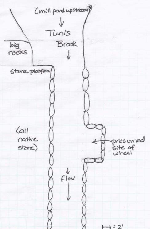
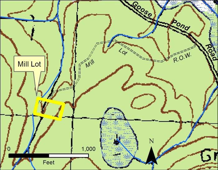
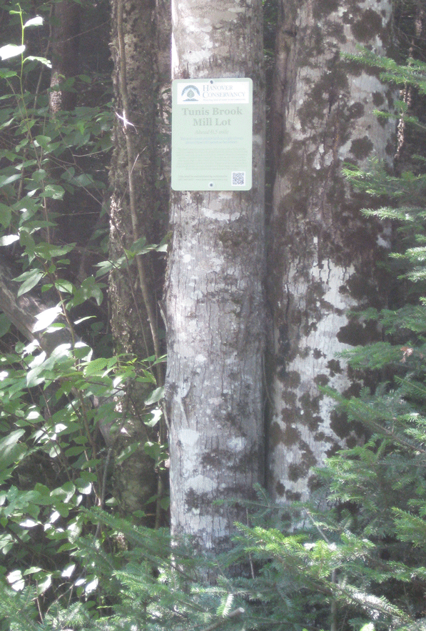
This Sunday, June 17th from 10:30-noon, join Lee Steppacher for this peaceful walking meditation at one of our less-visited properties, the Tunis Brook Mill Lot. Directions here.

slade

Take a moment to pause in the midst of a busy summer weekend to enjoy an easy, mostly silent mindfulness in nature experience. The trail is a very gentle ~0.5 mi. each way, with time to sit individually by the shaded brook. First-timers and daily practitioners alike are welcome!

Bring whatever you need to sit comfortably for 20 minutes; bug spray, towels and a few camp chairs will be provided for your convenience. Long pants and sleeves are recommended to ward off insects. Sunday morning will be very warm, but we’ll be shaded and near water much of the time. Questions? Call Courtney at (904) 536-9682.


Filed Under: Events, Outdoor Trips, Tunis Mill Lot Tagged With: historic, mill, mindfulness, trail, Tunis

Tunis Brook Mill Lot

February 1, 2017

Hike Directions & Map – Full PDF

Mill Lot mapDriving Directions

  • From Route 10 north of town, turn R onto Goose Pond Road and set your odometer.
  • Drive E on Goose Pond Rd. 5.4 miles (1.6 miles from where pavement ends for the second time).
  • Find the trailhead on the south side of Goose Pond Road, marked with a green Conservancy sign and red flagging. It is nearly opposite a gate bearing a yellow sign reading “Private Road – Bear Hill Reservation.” If you reach a large roadside pulloff on the R, you’ve gone too far.
  • Please park as far off Goose Pond Road as possible, and do not block the gate.
  • Today’s hike, shown on the map above, is an out-and-back trip to an historic site in the woods.

What You Should Know

  • Tunis Brook trailheadYou’re about to visit the Conservancy’s smallest property, a 1.5 acre gem with a mysterious history. Hidden deep in the wild forests of Hanover’s northeast corner, at the foot of Moose Mountain, is the site of a 19th century sawmill on tiny Tunis Brook.
  • In winter, we suggest snowshoes rather than skis because of uneven ground at the mill lot. The trail, however, is fine for experienced backcountry skiers.
  • The half-mile trail is marked with flagging and passes over private land on a right-of-way to the mill site. Conservancy volunteers maintain this trail.
  • Dogs are welcome if under your control; please pick up after your pet.
  • Snowmobiles, ATVs, and bicycles are not permitted.

Brief Hiking Directions

  • Begin on the trail at R of the Conservancy sign.
  • Follow the flagged half-mile-long right of way path for about 25 minutes to the Conservancy property, which is marked with a wooden sign.
  • Explore the mill site and return by the same route to Goose Pond Road.

Full Hiking Directions

  • Begin your hike on the trail that leaves to the R of the Conservancy sign, and note the time.
  • The trail is mostly flat and follows an old tote road that can be traced to the mid-1800s. Here and there, saplings grow in the route; we leave them to discourage vehicles.
  • The Mill Lot is part of a large block of contiguous forested wildlife habitat, much of it already conserved or owned by people with conservation intent. The Hanover Conservancy acquired the tiny parcel in 1994 with a gift of $5,000, to protect it from becoming the site of a vacation home deep in the forest. Close to Hanover’s Goodwin Forest, Town Forest, and also its McKinley Tract and Marshall Brook Wetlands (which the Conservancy helped the Town acquire in 1993 and 1977, respectively), the Mill Lot is a piece of the conservation puzzle in this wild corner of town.
  • A few minutes’ walk from your car, cross a small drainage on a pair of logs. In snow, you might see only a slender birch handrail, placed by our volunteer. Another crossing comes up soon after.
  • You’re passing through cool northern forest dominated by hemlock, spruce, and northern hardwoods such as yellow birch. Ruffed grouse live here year-round; look for their arrow-shaped tracks.
  • Look for moose tracks too – this trail seems to be a moose right-of-way! We see moose sign every timtrack beside a glove
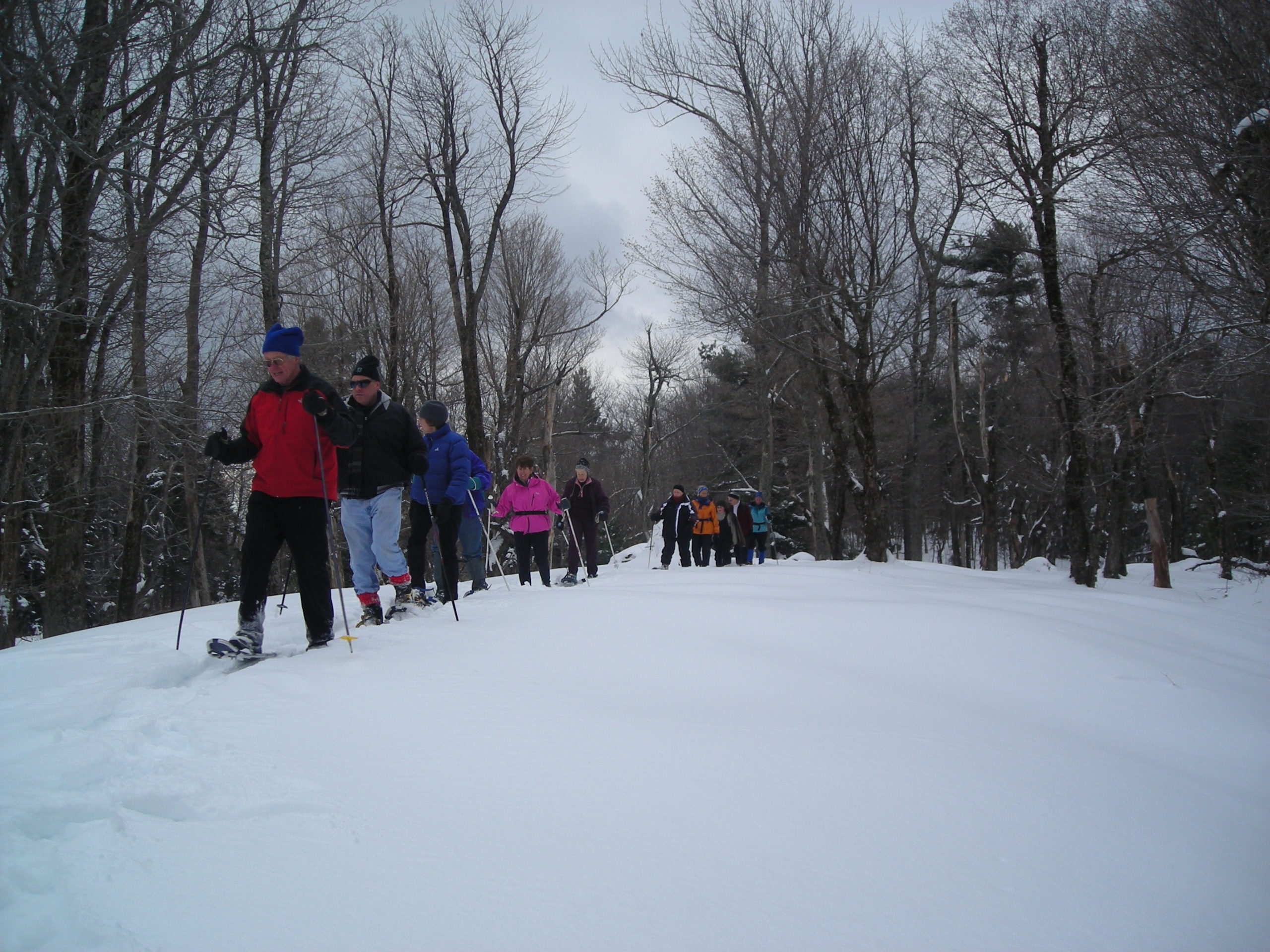
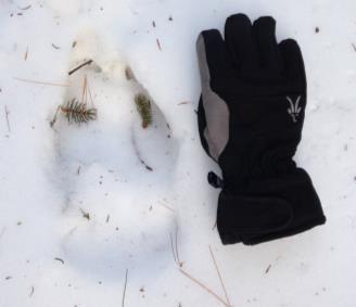
e we visit. Bobcat, bear, snowshoe hare, and coyote also frequent the area. Deer use a nearby wintering yard of dense softwoods. Small mammals include red squirrels, voles, moles, shrews, and mice.
  • About 12 minutes’ walk from your car, the trail heads gently uphill and narrows, turning L through an intimate alley of young pines and hemlocks growing in the right-of-way. Their foliage muffles sound and you feel deliciously a part of the forest, privy to its secrets.
  • The trail soon leads down into a little valley. Look for tracks of bounding snowshoe hare. Scattered on the snow might be spruce and fir tips, nibbled off by porcupine or red squirrels.
  • At an opening, look for a big boulder at R and a flagged, striped maple just beyond. The maple bears wounds from moose and deer rubbing their antlers against its bark.
  • About 20 minutes from your car, cross another small drainage.
  • Five minutes later, bear R past another large boulder, at a tree marked with double red flagging. A wooden sign ahead signals your arrival at the Tunis Brook Mill Lot. The brook may be covered with snow, but you will hear its music beneath.
  • To your R, the intriguing drylaid stone foundations of a sawmill are visible on the banks of Tunis Brook. Amos Kinne likely built the mill around 1849. Tax records suggest that the mill was active at least from 1850-1861. If snow obscures the mill ruins, resolve to return in spring to inspect them more fully!
  • mill site mapThe foundation’s configuration suggests that this was an up-and-down sawmill, built over the stream and using waterpower to run a vertical, straight steel saw with coarse teeth – about six feet tall attached to a wooden frame that moved between two vertical fender posts. Because tiny Tunis Brook does not have much pitch here, water to push an overshot wheel and drive the saw was probably delivered via a millrace (trough or pipe of wood or iron) from a mill pond upstream, perhaps where a wetland is now.
  • No records exist of the mill’s abandonment, but we presume that flooding destroyed the mill in 1862 since it was not assessed in that year. Floods were recorded in the Upper Valley on April 19, 1862, also February 10, 1867, and for four days in October, 1869 (the “Great Freshet”). Clearing of forests for pasturage and farming by the mid-1800s affected many streams, causing the “flashy” flows capable of washing out mills and their dams.
  • Our 1.5 acre parcel, a grandfathered, non-conforming lot, has carried the name “mill lot” since at least 1860. The mystery surrounding its history grew as the chain of title came to a dead end in the late 1800s. We think it was lost in the estate of Kinne’s partner, Moses Colby, who lived on the Wolfeboro Road. The Town of Hanover auctioned it off a century later.
  • The lot may be tiny, but observers have recorded 32 species of birds here, including hawks, three species of woodpeckers, and a variety of warblers. Here, you might find tracks of two members of the weasel family, the fisher and American mink.
  • Now let’s visit another landmark – one of the largest glacial erratics in Hanover (a huge boulder deposited by the glacier as it melted). It’s nearby but out of sight of the mill.
  • Follow the brook upstream, counting your paces. Within 75 paces, you’ll see the boulder looming ahead, and you’ll reach it in 75 more.

    Dick Birnie by erratic
    Geologist and Conservancy Board member Dick Birnie on a trip to evaluate the erratic
  • The erratic is composed of quartz, potassium feldspar, and black mica, with stripes of quartz. This boulder dropped out of glacial ice; its angular appearance indicates it did not roll along the ground. A smaller angular boulder on top is further evidence that it fell out of the ice. It came from nearby, possibly plucked off Winslow Ledge in Lyme. Its east side displays a flute, a classic glacial sculpture that was in place before it was plucked off the side of the cliff. Remains of a wooden ladder beneath hint that this once served as a hunting stand. (R: Geologist and former Conservancy Board member Dick Birnie on a trip to evaluate the erratic).
  • Now follow the stream back down toward the Conservancy’s wooden sign. Halfway, you’ll see our small green boundary markers.
  • Tunis Brook flows north to join Pressey Brook and eventually feeds Goose Pond and the Mascoma River. These waters are protected and purified by the healthy, mature forest sheltering Tunis Brook. This is a good thing – these waters ultimately become part of the City of Lebanon’s drinking water supply.
  • The Conservancy’s studies of borings of trees on the mill lot show that its forest is composed of three age classes (about 140 years, 110 years, and 75 years). This suggests that the forest started to grow when the mill was abandoned, with two later disturbances that created openings for new trees. While the ’38 Hurricane might explain the youngest age class, what prompted the middle one is unclear.
  • To find your way back, start at the wooden sign and follow the flagging. This time, keep an eye out for concentrations of tracks that indicate wildlife trails.
  • Be sure to come back in the spring (before black fly season), when Tunis Brook will have much more to say!

February 2017, updated July 2020

Filed Under: February, Hike of the Month, Tunis Mill Lot Tagged With: erratic, mill, moose

Mill Pond Forest & Dana Pastures

February 1, 2016

HIKE DESCRIPTION & MAP – Full PDF


Driving Directions

  •  From Etna village, turn R onto Ruddsboro Road
  •  Follow Mink Brook as the road curves up its narrow valley
  •  Pass Three Mile Road
  •  At 2.0 miles from Etna, turn L onto Old Dana Road
  •  At 2.4 miles from Etna, turn R onto Moose Mountain Lodge Road just past the historic Dana Barn
  •  Head up Moose Mtn. Lodge Road 0.9 miles to its end
  •  Bear R at a fork and park at the marked trailhead parking area. Please do not block driveways to the two neighboring homes.

Two Options

  •  ½ hour easy visit to the pond, pastures, and views, retracing your steps
  •  1-hour relatively easy loop, with visit to the three Dana pastures, exceptional views, and tour around the pond

What You Should Know

  • Hiking times are approximate.
  • Foot travel only. If there are ski tracks in the path, please walk beside rather than in them.
  • Dogs are welcome if under your close control; please pick up after your pet and do not allow it to chase wildlife. Porcupines are active.
  • Hunting is permitted in season.
  • You will visit both the 18-acre Mill Pond Forest and 313-acre Shumway Forest, privately owned and protected with conservation easements held by the Hanover Conservancy, and the 66-acre Dana Forest and Pasture Natural Area, owned jointly by the Town of Hanover and a private citizen and managed for conservation purposes.

Hiking Directions

For both options: Begin at the trailhead sign for Mill Pond Forest and Huggins Trail Access. You are standing on privately owned property that was conserved in November, 2015 with the Hanover Conservancy.

  • In 2015, the Shumway and Huggins families generously donated a conservation easement on this area to the Hanover Conservancy, to ensure that the public would always have access to the trails you are about to visit and to protect water quality and an early mill site on Mink Brook.
  • The trail moves past a series of pools in Mink Brook. Depending on whether beavers are active, this area can be some of the best evidence in town of a beaver’s construction skills. Cross a small drainage to reach the Dana Pasture Natural Area, jointly owned by the Town of Hanover and a private heir of the Dana family.
  • After two minutes’ walk, you’ll arrive at a fork. Bear L for a quick visit to the pond shore.
  • Just past the fork, you’ll see the c. 1800 cellar hole of the Woodward home at L. David Woodward was a miller who built a stone dam at Mill Pond and a saw and gristmill on Mink Brook as it tumbles down the mountainside beyond where you parked.
  • Continue on this short path to the shore, where you’ll find a bench at the water’s edge. At this season, little seems to move, but it’s a great place to look for waterfowl when the pond is clear of ice. Woodward’s stone
    Kay Shumway visits Mill Pond

    dam is just out of sight at L. Across the pond, a low mound indicates a large beaver lodge that was occupied until 2018.

  • Return to the cellar hole and trail junction, turning L onto Pasture Road, a very old Class VI road, marked with  a wooden sign posted on a pine, with another green moose sign nailed below.
  • Follow Pasture Road for about 2 minutes, following a handsome stone wall.
  • Two minutes from the trail junction, look for a break in the wall and trail at R, marked just beyond the break with wooden signs reading “Baboon Bypass” and a green moose. Watch for real moose sign as you venture out today –there’s a reason for Moose Mountain’s name! You may also see tracks of wild turkey, grouse, bobcat, porcupine, fisher, fox, coyote, and of course, deer.
  • Turn R, head up the path; cross a small drainage, and bear L as the trail swings toward an opening. Here, the promise of views lures you off the path. Walk about 35 paces to the edge of a drop-off and an old fence post silhouetted against the sky.

    Moose Mountain Lodge
  • Suddenly the world opens up to a stunning vista that stretches to the spine of the Green Mountains of Vermont. Killington and Pico peaks dominate the horizon. At your feet once stood Moose Mountain Lodge. Built in 1937-8 for skiers, the Lodge had a long and colorful history until it was demolished in 2019 by new owners. Learn more at hanoverconservancy.org/lands/easements/mill-pond-forest/ 
  • Please do not go beyond the fence posts and remnants of barbed wire on the property boundary; they remind you that this was one of the Dana family’s summer pastures for young cattle.
  • After you’ve inhaled the view, return to the trail and continue gently up the hill along the tree line toward a second pasture, following occasional orange flagging.
  • Continue uphill toward the third and highest pasture.
  • Note barbed wire fencing and clumps of juniper on L, more signs of the land’s grazing history.
  • Elisha Huggins leads a Conservancy snowshoe trip down through the third pasture

    Head up the gentle slope to a line of white birches that marks the southern boundary of the Dana Pasture Natural Area. After cattle were no longer pastured here, these meadows were kept open for years by neighbor Elisha Huggins, who mowed them with a hand scythe. Today, these openings offer fine wildlife habitat, especially in early summer when lowbush blueberries offer food for bears and many kinds of birds.

  • At the top of this pasture, you can extend your hike by continuing south on the orange-blazed Ridge Trail to ledges that offer remarkable eastern views. Today, we’ll return to Mill Pond.
  • Retrace your steps for 10 minutes through the three pastures and back to Pasture Road, all the way to the stone wall. (A path to the L after the last pasture, well before you reach the wall lining the road, leads to a private home).
  • At Pasture Road, turn L to return to your car (5 minutes) or take the ½ hour loop around Mill Pond.

For the pond loop:

  • Turn R on Pasture Road and immediately L.
  • Follow this path as it meanders among the spruce a short distance from the pond, keeping the pond on your left. You’ll cross small drainages that feed the pond; step carefully.
  • In about 10 minutes, a short spur to the left leads to the shore; bear R up the hill to a junction marked “Orange Diamond Trail” just visible ahead. A short distance above the pond, northern hardwoods take over for the red spruce and hemlock that cling to the water’s edge where cold air settles.
  • Turn L to continue on the Pond Loop. In a few yards you’ll step off the Dana Pasture Natural Area and onto the privately-owned Shumway Forest.  In 2017, the Shumway family conveyed a conservation easement to the Hanover Conservancy on 313 acres to protect wildlife habitat and public access to the network of trails on Moose Mountain, many of which they maintained for the public and for guests at their Moose Mountain Lodge. The Forest is now under new ownership, but the conservation protections will remain in place forever.

    snow-covered beaver lodge
  • Follow the Pond Loop Trail N for about 7 minutes to the gravel road that serves a nearby communications tower. The trail is not frequently blazed in this area. Keep the pond on your left.
  • Turn L on the tower road and walk down it along the north shore of the pond. Other than vehicles servicing the tower or those involved in forestry, no vehicles are permitted on this road.
  • After 5 minutes, reach a gate and turn L onto Moose Mtn. Lodge Road to return to your car.
  • Peter Shumway pauses by the pond

    Send a silent message of thanks to the generous landowners who made your visit possible!

February 2016, revised January 2021

Filed Under: Dana Pasture Lot, February, Hike of the Month, Moose Mountain Tagged With: cellar hole, mill, pond, views

Thank you for your support!

Our generous members and Corporate Conservators help make all of this possible. If you’re a customer of  our local business supporters, please let them know their contributions are appreciated!

71 Lyme Road
Hanover, NH 03755
(603) 643-3433

info@hanoverconservancy.org

Facebook logo   Instagram   YouTube

Get Involved

Become a Member

Volunteer

Business Sponsors

Conserve Your Land

Employment

Our Mission

Advocacy

Conservation

Education

Stewardship

Explore Hanover

Hanover Hikes

Upcoming Events

Upper Valley Hikes

Trails Challenge

Copyright © 2023 Hanover Conservancy | Design by Chase Brook Software