Hanover Conservancy

Facebook logo   Instagram   YouTube          
Donate button
  • Home
  • About Us
    • Employment
    • What We Do
      • Advocacy
      • Conservation
      • Education
      • Stewardship
    • Celebrating 60 Years
    • Board & Staff
    • Membership Benefits
    • Contact Us
  • Get Outdoors
    • Hanover Lands
      • Balch Hill Natural Area
      • Mink Brook Nature Preserve
      • Other Properties
    • Hanover Hikes
    • Hanover Trails Challenge
    • Upper Valley Hikes
    • Exploring Nature at Home
    • Hunting
  • Events
    • Calendar
    • Spring Wildflower Scavenger Hunt
    • Private Events
  • Get Involved
    • Donate
    • Volunteer
    • Adopt a Trail
    • Corporate Conservators
    • Planned Giving
  • Education
    • School Programs
      • KAST
      • Connecticut River Studies
      • Hanover High School Scholarship
    • Request a Field Trip or Speaker
    • Research on Our Lands
    • Hanover History
    • Resources
  • News
    • Remembering Bob Norman
    • Reports & e-News
  • Conserve Your Land

Hudson Farm & the AT

January 1, 2018

Hudson Farm Trail Guide in PDF form


Driving Directions

  • From Etna, take Trescott Road north for 0.5 miles to the junction with Partridge Road.
    Park in the new parking area on the L side of the road (if it is plowed) at the blue sign reading “Old Highway 38 Trail.”
  • If the parking area is not accessible, continue up Trescott Road for another 0.4 miles to the AT parking lot on the R, just before a fence at the Trescott Water Supply Lands boundary. Your hike will end just across the road. To begin your hike, walk down Trescott Road to the new parking area at Old Highway 38.
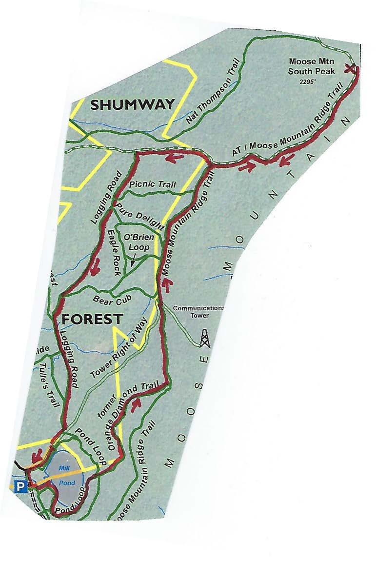
  • Today’s hike is a loop through the Hudson Farm’s fields and forest on an historic highway and the famed Appalachian Trail, highlighted on the map at R.

What You Should Know

  • You’re about to visit one of Hanover’s newest conservation properties! The National Park Service has purchased the Hudson Farm, owned for many years by Dartmouth College, to permanently protect it as part of the Appalachian Trail corridor. The conservation project is a partnership between the Trust for Public Land, Hanover Conservancy, and Town of Hanover, celebrated in June, 2017. In addition to major federal funding, many local contributions made the farm’s protection possible. Over the years, the property was eyed as a site for everything from a housing development to a cemetery and golf course. We like it just the way the bobolinks and deer do.
  • Hudson Farm kiosk in winterThe Appalachian Trail Conservancy manages care of the land. Trails on the property are maintained by Berrill Farm neighbors and Hanover Trails Committee volunteers. The beautiful meadows will be kept open for their spectacular views and grassland bird habitat.
  • Dogs are welcome but must be under your control; please pick up after your pet.
  • Snowmobiles, ATVs, and bicycles are not permitted.
  • In spring, wet areas make parts of this route difficult. Hunting is allowed in season.

Brief Hiking Directions

  • Follow the Old Highway 38 Trail up along the edge of the field for 0.2 mi.
  • Turn L at brown & yellow “Old Highway 38 Trail” sign for a brief detour to the nearby meadow for views.
  • Return to the sign in the first meadow and walk straight, down the hill and enter the woods.
  • Continue over boardwalks and through the woods to a junction with sign on L. Continue straight.
  • At the next junction, bear R; trail is now blazed blue.
  • Travel 0.2 mile and watch for pink flagging on trees and AT crossing (easy to miss).
  • Take sharp R onto AT; note white blaze on tree on R.  If you reach a playground you’ve gone too far.
  • Follow AT & white blazes 12 minutes to Trescott Road. Turn R.  Note orange sign at L at road.
  • Continue 0.4mi back to start.  Parking area will be at R at the base of the hill.

Full Hiking Directions

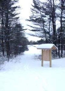
  • Begin your hike where the Old Highway 38 Trail meets Trescott Road. The Town of Hanover constructed a parking area here, opposite Partridge Road.
  • Take the path beyond the trailhead kiosk to an open field, keeping the tree line on your left. Winter is a good time to visit this expansive rolling field, which is alive with nesting bobolinks in spring and summer (when your dog should be on a leash, at least here).
  • Continue up the rise along the tree line that marks an old stone wall. You are walking through one of rural Hanover’s iconic historical farm landscapes.
  • Seven minutes’ walk up from the trailhead, you’ll reach the far corner of the field. Here you’ll notice a brown and yellow trail sign where two paths meet, directing you to the right. Instead, turn L for a brief detour through an opening in the stone wall to a second, equally beautiful meadow.
  • Stop for a moment to enjoy the expansive view. Straight ahead, the open hillside of Storrs Hill in Lebanon stands out, especially when covered in snow. At R are Rix Ledges, some of the most interesting terrain and wildlife habitat in Lebanon.
  • Approach the small group of trees in the field, 30 paces away. From this vantage point you can see Mount Ascutney rising in the distance, to the right of Rix Ledges.
  • RETURN to the first field and its brown and yellow trail sign. Until recently, you would have caught a glimpse of the late 18th century Adams Farm house. Once a lively tavern, it was likely home to the family that once owned the abandoned farmland you are exploring today.  To the R, amid a clump of trees, is a 20th century home built by later owners.  Archer Hudson, a retired architect, constructed the house as a country retreat and burned down the Adams Farm’s barn–the foundation of which remains.  Dartmouth College later purchased the property and carved off the house for resale, keeping the land.  While the College has long referred to it as the “Hudson Farm,” this is historically inaccurate as the property ceased to be a farm before the Hudsons acquired it.
  • From the trail sign, with your back to the second meadow, follow the arrow on the sign and walk straight (turning R would return you to your car) to follow the tree line down to the lowest point in the rolling field. Here the yellow-blazed Old Highway 38 Trail enters the woods. A bog bridge offers an easy way across a small wetland. On this hike you’ll encounter some huge, open-grown “pasture pines” – white pines that grew up on abandoned agricultural land, with many lower branches. Some of them are monsters!
  • Town Highway 38 has a murky history. Laid out in 1795, it originally led from Greensboro Road through this land to Trescott Road. In time it became a Class VI highway, but its exact route was so hard to trace that when planning began for the Berrill Farms neighborhood, the town agreed with the developer in 1979 on a route to be called the “Old Highway 38 Trail.” New LiDAR imagery of the Adams Farm just north shows traces
    of the old road heading toward the old tavern and then on to Trescott Road by today’s Bob Adams Road.
  • Soon you’ll ford another drainage on a crossing built in 2018 by Hanover Trails Committee volunteers. Protecting such headwater wetlands and streams from the erosion and runoff that comes with development is another reason to conserve this land – and will ultimately benefit water quality and trout habitat in Mink Brook from Etna to the Connecticut River.
  • Rising back to dry ground, you’ll encounter not one but two stone walls on the R, another reminder that this land was once open pasture. The second wall forms a corner as you approach and follows you for a distance. Fresh yellow blazes mark your path.
  • Soon, a sign at L indicates a turn in the Old Highway 38 Trail, where it will reach Greensboro Road in 0.9 miles. Instead, you continue straight toward the AT, 0.3 miles ahead.
  • As you continue, an open area is visible downhill at R; this is the forested wetland that is the source of the small drainage you crossed earlier.
  • 25 minutes’ walk from the trailhead, you reach another junction. The trail coming in at L originates at Bblue arrow sign in a tree
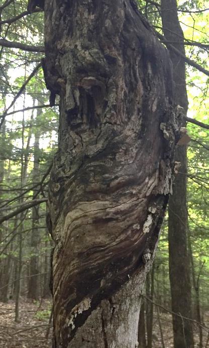
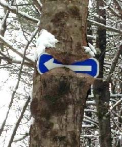
errill Farms. Above to the L, a tree seems to be gnawing on a blue arrow. Ahead at R, another tree has made less progress consuming its arrow sign. Bear R here and follow the arrow and blue-blazed trail downhill past a large old wolf pine at R.
  • You’ll soon reach the yellow-blazed boundary of the original federal land embracing the Appalachian Trail corridor, before the corridor was expanded with the addition of the Hudson Farm. If there’s no snow cover today, you’ll notice the stone wall forming the old property boundary and the AT boundary pin next to the trail. Continue on the blue-blazed trail. Watch for ice underfoot as you cross a small drainage.
  • Keep an eye out for bits of “cultural debris” such as a sap bucket. This is a good time to note that hunting is permitted on the AT and federal land surrounding it, so it’s wise to wear orange if you’re out between Sept. 15 and Dec. 15.
  • A few minutes after passing the sap bucket, the famed Appalachian Trail crosses your path. While it is well marked with fresh white blazes, it can be easy to miss as the old trail continues straight. Turn R onto the AT and head for Mt. Katahdin (or maybe just your car). This is your second historic trail of the day. Benton MacKaye conceived of the regional trail in 1921, and after overcoming many obstacles including the 1938 Hurricane, World War II’s drain on trail maintainers, and the kind of political intransigence that is all too familiar, his vision became the National Scenic Appalachian Trail in 1968.
  • Hemlocks shelter the trail here; if weather conditions are right, it’s easy to see how their stiff needles and short branchlets capture and hold snow before it can fall to the ground. Deer and other wildlife take advantage of the shallower snow depths under hemlocks, where it’s easier to move around. Wildlife managers call such hemlock groves “deer yards” for this reason.
  • Soon you leave the hemlocks behind as the AT heads up a gentle knoll dominated by northern hardwoods. Continuing back down the north side, the trail enters evergreen forest again.
  • About 8 minutes after turning onto the AT, you’ll encounter another wetland. The log crossing may be buried in snow – watch your footing. In summer, this place begets very dirty dogs.Velvet Rocks trail sign
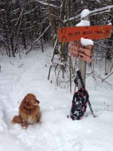
  • Four minutes later you’ll reach Trescott Road and the Dartmouth Outing Club’s orange sign for the Velvet Rocks Trail. The AT parking lot is visible to the L across the road.
  • If you left your car here, it’s time to end your hike. If not, turn R on Trescott Road and walk the 0.4 miles back down toward Etna and your car.

updated 9/1/2020


Filed Under: Hike of the Month, Hudson Farm, January Tagged With: Appalachian Trail, bobolink

Shumway Forest and Tom Linnell Ridge Trail

August 1, 2017

Hike Information and map – full PDF


Moose Mountain trail mapDriving Directions

  • From Etna Village, head N on Hanover Center Road
  • Turn R on Ruddsboro Road and drive 1.8 miles
  • Turn L on Old Dana Road
  • Turn R just past large red barn on R, onto Moose Mountain Lodge Road (not marked)
  • Drive 0.8 miles to top of road. Park in marked trailhead parking area just past the beaver dam.

What You Should Know

  • Foot travel only. Dogs are welcome but must be under close control.
  • Consider bringing binoculars and a bird book for viewing waterfowl on Mill Pond.
  • This hike passes through six major conservation parcels on Moose Mountain that are part of a 3,800-acre block of protected, un-fragmented wildlife habitat. The newest and largest is the 313-acre Shumway Forest, conserved by the Hanover Conservancy in June 2017.

Hiking Directions

  • Begin your hike at the green Mill Pond Forest/Huggins Trail Access sign. The Huggins and Shumway families donated a conservation easement on this area in 2015 to ensure that the public would always be welcome on their trails and have a dedicated place to park.
  • The trail heads E along a beaver-managed section of Mink Brook – look for evidence of beaver chews, slides, and an impressive series of dams.
  • You’ll soon reach a fork; a big pine at R bears a sign for Pasture Road. Bear L on the other trail. You have arrived at the 130-acre Dana Pasture Natural Area, a wonderful piece of land that holds an important place in the Dana Family history. Today, the Town of Hanover and a Dana heir own undivided half shares.
  • 15 paces from the fork, look for a cellar hole at L. This was the home of miller David Woodward, who built the dam on Mill Pond and an impressive sawmill and gristmill on the steep falls of Mink Brook below where you left your car (a visit for another day).
  • Continue 75 yards to the pond’s edge and a bench that beckons you to admire the view across the 10-acre pond. This is the highest water body in the town of Hanover and the primary source of Mink Brook, the town’s largest stream. Set in a saddle on the mountain ridge, it may have originally been a small pond or perhaps a marsh. In the late 1700s, Woodward built a drylaid stone dam (just out of view at L, beyond the spruces) to raise the water level some 6-8 feet (it has since partly silted in). Then beavers took over and have been managing the pond ever since. Today, the entire shoreline remains undisturbed: Hanover Conservancy easements protect the N side with the Dana Pasture Natural Area on the S.
  • beavers in pond
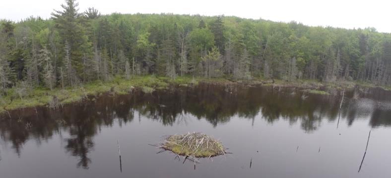
Directly across from the bench is an impressive beaver lodge. Scan the pond’s surface for waterfowl and other birds. You might be welcomed by the slap of a beaver’s tail.
  • Retrace your steps for a short distance to the Pond Loop (unmarked) at L, and begin your trip around the pond. In 3 minutes, come to a Y with the Baboon Bypass at R and an arrow pointing L.
  • Turn L here, keeping the pond at L. You’ll encounter some wet places, an old corduroy (log) crossing, and lush growths of sphagnum moss, goldthread, and club moss.
  • About 10 minutes’ walk from the bench, you meet a massive old white birch and side trails to the water. Continue straight to another big birch and a large maple snag, an apartment house for a variety of creatures. The trail continues around them.
  • Just a few minutes later you’ll arrive at a trail junction, and you have a decision to make.
  • The arrow points L to the tower road. If you just remembered you left something on the stove, this is the first of two bail-out points. To return to your car, bear L on the Pond Loop, heading N. The trail is easy to follow if you keep the pond in view at L and bear R at an arrow. You’ll leave the Dana Pasture Natural Area for the Shumway Forest before you reach the tower road 10 minutes from your decision point. Turn L to return to your car in another 4 minutes.

  • If you’re game for more adventure, bear R toward the sign reading “To the O.D. Ridge Trail.” The Orange Diamond Trail was built by a local snowmobile club in the 1970s but hasn’t been used that way for years. The trail, deemed by the club as unsuitable for today’s snow machines, is now restricted to foot travel.
  • Thank the Hanover Conservation Commission’s Trails Committee for restoring this and the Tom Linnell Ridge Trail, which it joins in 4/10 mile. The trail sees heavier use in winter than summer, so follow it with care.
  • Continue on the Orange Diamond Trail as it heads northeast through mixed northern hardwoods for 20-25 minutes. Bear L at forks in the path. Soon you leave the Dana Pasture Natural Area, briefly visit the Shumway Forest, and enter two lots fully owned by the Town of Hanover. The Conservancy helped the Town acquire the N one in 2002. Didn’t notice a break in the forest, did you? Wildlife doesn’t either! That’s the point of keeping habitat un-fragmented here on the mountain.
  • This is prime habitat for the kinds of wildlife that need large blocks of cold mountain habitat, including the snowshoe hare. We’ve seen not only the tracks but the creature itself, a white blur whizzing across a whitened winter landscape, with a bobcat in pursuit. Sheltered rocky crevices provide fine bobcat dens.
  • As the Orange Diamond Trail joins the Tom Linnell Ridge Trail, bear L to head due N. The Hanover Conservancy is assisting the Upper Valley Trails Alliance and Hanover Trails Committee with their project to formalize and protect public access to the Ridge Trail for its entire route from Enfield to the South Peak, under a grant from the Quabbin to Cardigan Partnership.
  • 20-25 minutes from the Pond Loop, arrive at the tower “road,” which was visible at L for the last few minutes. Here’s your second bail-out point: you can walk down the road to the gate and turn L to your car.
  • The tower road was built in the 1960s for construction and maintenance of the nearby communications tower. Despite what a surprising number of maps say, it is NOT a public Class VI road that goes over the ridge to Goss Road, nor is it part of Moose Mountain Lodge Road. A private right of way, it is blocked by a locked gate just above the entry from the Lodge Road. Hanover Conservancy easements on its lower half prevent use by vehicles except for forestry, wildlife habitat management, and of course, by the tower folk.

  • We hope you’re up for more adventure – if so, cross the road at its hairpin turn and re-enter the woods at the sign of the moose. The Orange Diamond / Tom Linnell Ridge Trail is wide and easy to follow here.
  • In 3 minutes, the O’Brien Trail (named for the Shumways’ forester, John O’Brien) leaves at L. John has an endearing habit of arranging skid trails so they make good hiking and XC ski trails.
  • Stay straight; you’ll soon encounter evidence of federal boundary blazes as the trail begins to snake the line between the Shumway Forest and federal land acquired in the 1980s for the Appalachian Trail.
  • In 2 minutes, bear R at a fork and sign reading “To the A.T.” The trail becomes a narrow footpath again, easy to follow as it begins to climb along the boundary. Look for some old sugar maples whose nearness to the line may have spared them the woodman’s axe.
  • Soon you’ll get hints of views to the E (R) as the trail swings L and continues up, not blazed but easy to see.
  • dog at Moose Mountain view20 minutes from the tower road, arrive at the Appalachian Trail. An orange Dartmouth Outing Club sign rests on the ground by a tree, pointing the way to the South Peak. Here, you can turn R to head to Mt. Katahdin in Maine. Turn left for Velvet Rocks, downtown Hanover, and if you’re really ambitious, Springer Mountain in Georgia. Today, we’ll turn R and take the AT for about 15 minutes to the S summit along the well-worn, gently but steadily climbing path.
  • Relish your reward at the South Peak: glorious views E, with Goose Pond at your feet and Mt. Cardigan, Sunapee, Kearsarge, and more visible on the SE horizon. At one point, the Presidentials are visible in the distance to the NE. Bedrock ledges offer comfortable seating. Search the raspberry thicket for ripe berries. You can bet the bears do.
  • steeplebush
  • At this season, native steeplebush is in full bloom (L), its rosy spires of tiny flowers alive with native pollinators. Dragonflies cruise the peaceful scene today, but in 1968, Northeast Airlines flight 946 crashed near this area. The rescue effort required bulldozers to clear a path to the wreckage.
  • The orange DOC sign indicates that the South Peak’s elevation is 2222’ above sea level. More refined measurements indicate it’s actually 73’ higher.
  • When you’re done drinking in the view, head back down the AT the way you came. The junction for the O.D. Ridge Trail appears just after a raised log/stone section of trail. Enter the Shumway Forest once again and continue down the AT past this trail. Volunteer AT trail maintainers have been here – step over rock water bars that keep water from sluicing down the trail and creating gullies.
  • About 8 minutes from the O.D. Ridge Trail junction, the trail flattens out – your cue to look for the Logging Road entering at L. Find the trail sign mounted on a large paper birch a short way in.
  • Turn L here, off the AT (if you continued, you’d arrive at Three Mile Road). You’re passing through a “sandwich” of easements placed by the National Park Service in 1983. A 200’ Trail Right of Way Easement follows the AT itself with a pair of protective easements 200-461’ wide, one on each side of the Trail ROW.
  • The Logging Road heads briefly uphill and then follows the contour S. You will follow it for half an hour through the Shumway Forest. This is your best chance at seeing moose that use this trail as a highway. Watch for their dinner plate-sized tracks in a few wet areas that appear here and there.
  • About 9 minutes from the AT, the Picnic Trail comes in at L. Ferny openings indicate the Logging Road’s path SSW. A few minutes further at a small opening, bear L and the trail, now more clearly a former skid trail, leads on.
  • Note the carefully constructed water bars on the route, built for past years’ logging operations to control water flow. Brush piles were laid to help return nutrients to the soil and provide small mammal habitat. The Shumway Forest has been under the supervision of a professional forester ever since the current owners, Kay and Peter Shumway, purchased what was then a heavily logged property in 1986 from a timber company to prevent construction of a mountaintop vacation home by another would-be buyer.
  • The Shumways manage the land primarily for public recreation and also to steer the forest back to a healthy and ecologically intact system with a variety of habitats for wildlife while protecting streams and wetlands. The new conservation easement ensures that this management will continue, adding a 100’ protective buffer for those waters.
  • About 20 minutes from the AT, the Bear Cub Trail comes in at L and soon you arrive at a grassy log landing. Bear L, away from the large open area, and continue up into the woods. Wildlife feed in such openings surrounded by forest cover. The Logging Road becomes stony here, hardened to take the weight of forestry vehicles. You’re starting to think this might be a wonderful ski route in winter, and you’re right!
  • In 4 minutes the Middle Mountain Trail and Mountainside Trail leave at R, and in a few more, you arrive at a second log landing. Just beyond is the tower road. Signs on a tree at L include a trail map. Turn R on the tower road.
  • Now it’s time to explore the north shore of Mill Pond. Two minutes from the Logging Road, the pond comes into view as you leave the Shumway Forest and enter the Mill Pond Forest, where the Shumways and Hugginses donated a conservation easement to the Hanover Conservancy in 2015.
  • Mill Pond with beaver lodgeTurn L opposite a telephone pole and take the short trail to the water’s edge. The beaver lodge is close by, and the bench you visited earlier is visible on the far shore at 2 o’clock. Lush northern shoreline vegetation is underfoot: sphagnum moss, ferns, and lichens. This thick carpet captures sediment running off the mountainside and helps keep Mink Brook crystal clear.
  • Turn R to follow the path along the shore, crossing a few beaver slides, noting the reeds with their tousled “bad hair day” seedheads. At a fork in the path, stay L on the pine-needle carpeted trail to where a small cove indicates the old dam overflow. The dam is just beyond, obscured by beaver engineering and shrubs.
  • Bear R and head for the green gate at the entrance to the tower road. Turn downhill past the gate and L to return to your car.

The Hanover Conservancy holds permanent conservation easements on the Shumway Forest, Mill Pond Forest, and Huggins Trail Access, which remain privately owned. Please respect the generosity of these landowners by leaving no trace of your visit and enjoy the memories and photographs you take home.

Filed Under: August, Hike of the Month, Moose Mountain, Shumway Forest Tagged With: Appalachian Trail, beaver, snowshoe hare, steeplebush

The Velvet Ledges of Greensboro Ridge

June 1, 2016

Greensboro Ridge Hike – Full PDF

Map of Greensboro Ridge trailsDriving Directions

  • From the traffic light at Route 120 and Greensboro Road, turn east on Greensboro Road.
  • After 0.4 miles, turn left onto Velvet Rocks Drive.
  • Proceed up the hill to the parking area at the road’s end.

What You Should Know

  • Foot travel only, except on the Silent Brook Trail where bikes are allowed. Dogs are welcome but must be under close control; please pick up after your pet. Be aware that this Natural Area is prime porcupine habitat!
  • The trails are blazed in colors matching the trail map: blue for Oli’s Eagle Trail, white for the Appalachian Trail, and light orange for the Greensboro Highlands Trail. The wider Silent Brook Trail is not blazed but is easy to follow.
  • The Hanover Conservancy owns and manages the Greensboro Ridge Natural Area. The Town of Hanover holds a conservation easement on the land. After a housing development was proposed for this entire forested hillside, the Hanover Conservancy and Town worked with the developer to cluster homes close to the road and conserve the remaining acreage. The Conservancy acquired the land in 2008, protecting valuable wildlife habitat, a scenic backdrop, and a wonderful natural area with trails for the new Velvet Rocks and Silent Brook neighborhoods and the greater community to enjoy.

Brief Directions

  • Take Oli’s Eagle Trail north from the trailhead kiosk to the junction with the Appalachian Trail.
  • Retrace your steps a short distance to turn L onto the Greensboro Highlands Trail.
  • Follow this down to a T with the Silent Brook Trail.
  • Turn R to return to your car.

Full Hiking Directions

  • Take a moment to check the trailhead kiosk display and map. We are grateful to Trumbull-Nelson for the gift of this beautifully hand-crafted kiosk.
  • Oli’s Eagle Trail begins just to the L of the kiosk, heading up through a narrow rocky cleft. The contrast between this rough terrain and that tamed for the Velvet Rocks development is dramatic.
  • This trail was built in 2008 by Oliver Simpson for his Eagle Scout project with help from the Hanover Conservation Commission’s Trails Committee.
  • In early June, the foliage of purple trillium is still apparent near the trail entrance, although here at the warmer, lower end of the trail, the wildflowers may have gone by.
  • You’ll soon reach an open expanse of unfurling ferns, primarily the sweetly fragrant Hay-Scented Fern. Watch your footing here. This opening was cleared from the forest as a demonstration house site before the land was protected. It will be kept open to provide habitat variety for wildlife.
  • Heading back into the woods, you can hear the gurgle of a small stream as the trail curves gently to the right. Fisher and mink inhabit this area. The Natural Area is located in the Mink Brook watershed; protecting this land helps keep the waters of Mink Brook cool, clear, and comfortable for wild brook trout.
  • Eight minutes from your car, you’ll begin climbing the ridge. Follow the blazed trail as it crosses a tiny drainage and winds up through a narrow cleft in the rocky ledges.
  • trillium
  • By 18 minutes’ hike from your car, you’ll notice the rise in elevation and cooler forest conditions. The trillium has noticed it too, and may be still in bloom along the trail (photo L).
  • A few minutes later, you might notice the work of pileated woodpeckers on an old tree on the L side of the trail.
  • At 22 minutes from your car, you’ll reach the junction with the Greensboro Highlands Trail, marked with a wooden sign. You’ll soon return to this junction but now continue straight on Oli’s Trail for a minute or two to reach the white-blazed Appalachian Trail. The AT actually dips off federal land and onto Hanover Conservancy property for a short distance. At that junction, you could turn R to head to Etna or Mt. Katahdin in Maine or L for Velvet Rocks, downtown Hanover, or if you’re really ambitious, Springer Mountain in Georgia.
  • Instead, turn around and retrace your steps for a short distance on Oli’s Trail, turning L onto the Greensboro Highlands Trail to continue your hike. The Hanover Conservancy, with help from the Upper Valley Trails Alliance and a team from Hypertherm, built the Greensboro Highlands Trail in 2012 to create this loop.
  • 25 minutes from your car, you’ll note a fragment of stone wall at L, a reminder that this heavily forested land was once an open sheep pasture.
  • old branch collar in treeIn 2 more minutes, a fun photo opportunity appears on the right, where an old branch collar on a dead snag forms the perfect frame (R). Friends can take a photo of faces looking through it to post on our Facebook page!
  • Black bear make their home here, and it’s easy to find bear claw marks on the smooth bark of beech trees, evidence of a bear seeking tasty beechnuts.
  • 32 minutes into your hike, the trail winds to the R around a ledge featuring a huge and handsome vein of white quartz.
  • "face" in old tree
  • In another 2 minutes, see if you can spot the guardian of this forest. This “face” on a tree (photo L) appears on the L side of the trail.
  • 38 minutes into your hike, the trail splits around a large boulder, then a few yards later turns somewhat sharply L. There are a lot of well- worn game trails here and it would be easy to follow one if you were looking at the ground- be sure to look for the orange blazes!
  • Look carefully for signs of one of the Natural Area’s hidden gems –its 8 vernal pools. These usually ephemeral wetlands are essential breeding habitat for salamanders and frogs, as they are free of fishy predators. (Please keep your dog from cooling off here.)
  • At 45 minutes, another stone wall appears at L, marking the HC boundary. A wetland is visible just behind it as you near the trail junction for Silent Brook.
  • 48 minutes into your hike, you’ll reach the Silent Brook Trail. This trail, designed to link the Silent Brook and Velvet Rocks neighborhoods, is open to bicycles. If you turn L, you’ll reach the Silent Brook neighborhood in less than 5 minutes. To return to your car in just a few more, turn R onto the Silent Brook Trail.
  • volunteer mounting a trail signCross a small drainage on a footbridge and enter another ferny opening. Here, white pines are doing what they do naturally – reclaiming old openings – and volunteers are working to keep this area, another demonstration house site, open for wildlife.
  • The trail drops steeply and crosses another small wooden bridge before returning to your car and the parking lot at the end of Velvet Rocks Drive.

Note: The Hanover Conservancy is seeking volunteers to advise us on managing the Natural Area, monitor trails, and help out with very occasional work parties. We also warmly welcome donations to our Land Stewardship Fund to help maintain the Natural Area. More info about the Natural Area can be found here.

June 2016, revised September 2020

Filed Under: Greensboro Ridge, Hike of the Month, June Tagged With: Appalachian Trail, hay-scented fern, porcupine, purple trillium

  • « Previous Page
  • 1
  • 2

71 Lyme Road
Hanover, NH 03755
(603) 643-3433

info@hanoverconservancy.org

Facebook logo   Instagram   YouTube

Get Involved

Become a Member

Volunteer

Business Sponsors

Conserve Your Land

Employment

Our Mission

Advocacy

Conservation

Education

Stewardship

Explore Hanover

Hanover Hikes

Upcoming Events

Upper Valley Hikes

Trails Challenge

Copyright © 2026 Hanover Conservancy | Design by Chase Brook Software