Hanover Conservancy

Facebook logo   Instagram   YouTube          
Donate button
  • Home
  • About Us
    • Celebrating 60 Years
    • What We Do
      • Advocacy
      • Conservation
      • Education
      • Stewardship
    • Board & Staff
    • Membership Benefits
    • Contact Us
  • Get Outdoors
    • Hanover Lands
      • Balch Hill Natural Area
      • Mink Brook Nature Preserve
      • Other Properties
    • Hanover Hikes
    • Hanover Trails Challenge
    • Upper Valley Hikes
    • Exploring Nature at Home
    • Hunting
  • Events
    • Calendar
    • Spring Wildflower Scavenger Hunt
    • Private Events
  • Get Involved
    • Donate
    • Volunteer
    • Adopt a Trail
    • Corporate Conservators
    • Planned Giving
  • Education
    • School Programs
      • KAST
      • Connecticut River Studies
      • Hanover High School Scholarship
    • Request a Field Trip or Speaker
    • Research on Our Lands
    • Hanover History
    • Resources
  • News
    • Remembering Bob Norman
    • Reports & e-News
  • Conserve Your Land

Announcing Spring Trips!

March 29, 2023

Our spring roster of trips is now ready! Current Hanover Conservancy members will receive a colorful announcement shortly. Come explore with us! Our trips are free and open to all.

Follow the link below for a list of our upcoming trips.

Spring Trip Calendar

Filed Under: Balch Hill, Birds, Events, Featured, Forest Ecology, Greensboro Ridge, Hudson Farm, Indoor Programs, King Bird Preserve/Hayes Farm Park, Lands, Outdoor Trips, Partnerships, Uncategorized, Wildlife Tagged With: Howe Library, Outdoor Events, Outdoor trips, spring, Spring trips, Vernal pools

Old & New Etna Loop

September 29, 2020

HIKE DIRECTIONS & MAP – Full PDF

Driving Directions

  • From Etna, take Trescott Rd northwest for 0.5 miles to the junction with Partridge Rd.
  • Park in the parking area on the L (W) side of the road at the blue sign reading “Old Highway 38 Trail.” If the area is not accessible, continue up Trescott Rd 0.4 miles to the AT parking lot at R, just before a fence at the Trescott Water Supply Lands.
  • Today’s hike is a loop through the Hudson Farm’s fields and forest on an historic highway, behind Etna village on the famed Appalachian Trail, and down Hanover Center Rd. to the Etna Library, the Audrey McCollum Trail, and Partridge Rd.

What you should know

  • This is a mostly easy hike with a few short steeper sections and some with tricky footing among roots or rocks. The route is well-blazed and signed.
  • The route follows an early road on one of Hanover’s newest conservation lands. In 2017, the Hudson Farm (brown-shaded area on map) was permanently protected as part of the Appalachian Trail corridor.
  • The Audrey McCollum Trail, built by the Hanover Trails Committee from Hayes Farm Park to Woodcock Lane in 2017, was extended in Summer 2020 to Partridge Lane to provide improved access to the central conservation area owned by the Town of Hanover.
  • Trails are maintained by Trails Committee volunteers.
  • Dogs are welcome but must be under your control and must be leashed on the McCollum Trail; please pick up after your pet.
  • Deer hunting is permitted (except at Hayes Farm Park) by archery Sept. 15-Dec. 15
  • Foot travel only; snowmobiles, ATVs, and bicycles are not permitted.
  • Please respect nearby private property.

BRIEF HIKING DIRECTIONS

  • From the Hudson Farm parking area, take Old Highway 38 south to the rise in the meadow.
  • Turn R at sign for Old Highway 38 Trail and 38A Connector.
  • Stay straight at next trail junction; turn R at T toward Appalachian Trail.
  • Turn R (N) on AT, cross Trescott Road, and continue on AT to Hanover Center Road.
  • Turn R (S) on Hanover Center Road; follow to Etna Library.
  • Turn R into parking lot and take trail into meadow to junction with Audrey McCollum Trail.
  • Bear L onto Audrey McCollum Trail; follow this to Woodcock Lane.
  • Turn R onto Woodcock Lane and then L to new section of McCollum Trail.
  • Follow this to Partridge Road.
  • Turn L and walk along Partridge Road to Trescott Road; cross to reach your car.

FULL DIRECTIONS

  • Begin your hike by passing the kiosk and taking Old Highway 38 along the treeline up to the rise that is visible from the trailhead. At this season, the old field is filled with nodding goldenrod, small white asters, and periwinkle New England asters. Start “collecting” stone walls! Among the leaves cloaking the hedgerow at L is the first, a low stone wall separating two former pastures of the historic Adams Farm.
  • 5 minutes’ walk brings you to the top of the rise and a brown/yellow trail sign where two mown paths meet. Look back at R – easily visible is a white 20th century home built as a country retreat by retired architect Archer Hudson. Beyond another hedgerow stood the Adams Farm house from 1790 until 2024, a former tavern and home of the family that once owned the former farmland you are exploring now. Hudson purchased land that included the Adams barn – and then burned it down. Dartmouth College later bought the property and carved off his house for resale.  While the College referred to it as the “Hudson Farm,” the land ceased to be farmed when Hudson arrived.
  • In June, 2017, this was the site of a grand celebration. A partnership between the Trust for Public Land and the Town of Hanover, assisted by the Hanover Conservancy, resulted in the purchase of 175 acres by the National Park Service to permanently protect them as part of the Appalachian Trail corridor. In addition to major federal funding, many local contributions made this possible.  Owned for many years by Dartmouth, the property had been eyed as a site for everything from a cemetery and golf course to a housing development. Today, the AT Conservancy manages the land with help from the staff of the White Mountain National Forest.  The beautiful meadows are kept open by carefully prescribed burns, for their spectacular views and valuable grassland bird habitat.
  • Turn R at the sign to follow the Old Highway 38 Trail and pick up the 38A Connector. The trail heads down to the woods; crabapples at the edge, a remnant of farming days, bear colorful fruit at this time of year. Yellow blazes mark the trail.
  • Two sets of boardwalks offer dry footing across a wetland, built by Hanover Trails Committee volunteers (thank you!). Protecting such headwater wetlands and streams from heavy foot traffic benefits water quality and trout habitat in Mink Brook below. The wetlands act as sponges during heavy downpours, holding water to prevent flooding and erosion in downstream neighborhoods. While they may seem dry at this time of year, the coarse fronds of sensitive fern are a clue to wetter times. Keep an eye out for the intriguing white flowers of turtlehead. Their bee pollinators must muscle their way inside to gather their nectar.
  • Rising up and away from the wetland, you’ll soon see a pair of stone walls at R, reminders that this was once grazing land before the forest returned. The second turns a corner and follows the trail.
  • 7 minutes’ hike from the first trail sign, note another at L where Highway 38 turns L. You continue straight on the 38A Connector for 0.3 miles to the Appalachian Trail.
  • Head over stepping stones on what may be a dry crossing at this season. The trail is now blazed blue, indicating a, AT connection trail. The rolling trail moves through mixed woods in former pastures.
  • 5 minutes from the last junction, arrive at a T. Blue and white arrow signs in nearby trees (which seem eager to devour them) mark your R turn down the hill, following blue blazes. Mark the time – you’ll see why.
  • As you approach the clearly marked boundary of the old AT corridor – an 1800s stone wall, 1980s yellow blazes, and a 2017 boundary pin – you note that the forest understory is more open here. This land has a different history.
  • 10 minutes from your last turn, reach the pine-needle strewn crossing of the Appalachian Trail. It is easy to miss! The connector trail continues beyond the AT, bending around a yellow birch about 50’ ahead. Stop and look for the white blaze on a pine at R.
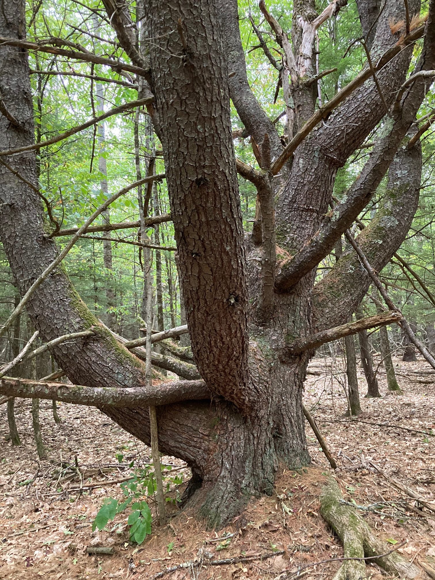
  • Turn R onto the famed – but here quite humble – Appalachian Trail, heading gently up for 7 minutes to the top of a low ridge. Stop here and note the big old “wolf pine” at L, a pretty impressive character. The growing tip of such a white pine was damaged early in its career, which let side branches develop into competing leaders. No longer valuable for timber, such pines were often left to provide shade for grazing animals – and to spook hikers.
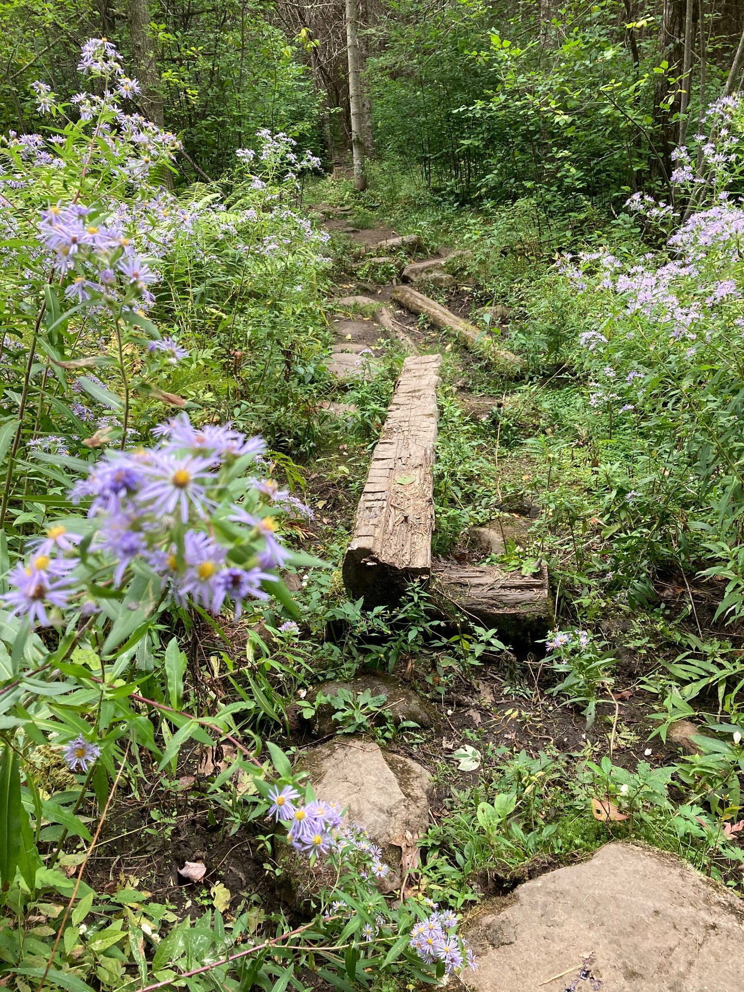
  • 4 minutes later, cross another small wetland decorated with asters and turtlehead.
  • On the far side, the forest understory is suddenly crowded with young buckthorn, an invasive tree. At this season, when most proper New England trees are beginning to shed their leaves or at least turn color, the non-native buckthorn reveals the secret to its grim success – it retains its green leaves and keeps on photosynthesizing well after the natives have checked out for the winter, giving it a competitive edge.
  • 4 minutes past the wetland crossing, arrive at Trescott Road. On the day we were out, during a drought, a thoughtful “trail angel” had left a cooler and big water bottle for thirsty hikers.
  • To continue on the AT, spot the trail across the road at one o’clock. A few steps in, a kiosk appears ahead. A path from the AT parking lot comes in at L, strewn with needles from the pine plantation it crosses.
  • Continue past the kiosk through thickly planted rows of pines, another part of the old farm that is now owned by the National Park Service.
  • After a small opening, watch for an odd rectangular structure of moss-covered concrete at R – was this the farm’s spring house? A few steps further is a spectacular round drylaid stone structure – possibly the foundation of a silo. Etna’s farming history is deep and rich – and its footprints are everywhere.
  • 5 minutes from Trescott Rd, emerge into an opening where the trail skirts the upper edge of the recently reclaimed meadow. A stone wall (the fifth or sixth so far?) appears at R as the trail re-enters the woods. As you leave the Trescott Rd corridor behind, invasive buckthorn in the understory is replaced by native cherry, ash, and striped maple.
  • The AT crosses a low stone wall as you note many blowdowns. These may date from the 2007 Patriot’s Day windstorm that leveled much timber here and on the east slope of Balch Hill, among other places.
  • Cross another stone wall, this one remarkable for its long, angular slabs. Who knew stone walls had different personalities? We’ve only just begun!
  • Continue north on the AT as it rolls along, skirting the W edge of Etna village. Cross yet another stone wall.
  • The trail bears L, arriving at an interesting intersection of stone walls that once must have divided pastures. The AT follows one on your L – note some venerable sugar maples lining it. As the trail rises, this wall becomes even more impressive, nearly reaching chest height. We can’t resist sharing here that in 1870, a government agency estimated that over a quarter million miles of drylaid stone wall had been built in New England and New York, most during a few decades in the early 19th century during the Sheep Craze. Recently, NH’s State Geologist has worked with area volunteers and UNH to create a citizen-based, on-line stone wall mapping tool using LiDAR maps. You can visit this site to see the stone walls you’re “collecting” on this hike (shown in pink on the image), and visit your own home area to see what other walls might exist nearby.
  • 5 minutes after crossing the last wall, you reach a height of land. A trail joins at R from the nearby neighborhood, and low wooden signs – along with a mystery object made of iron – invite you to stop and look around. Off just a few paces at L is a large and impressive cellar hole. It is the remains of another Adams farmhouse you’ve discovered. The Adams family once owned all the land between Dogford Rd and the E leg of Trescott Rd, over which you have been walking. When the farm was sold and subdivided to create the Trescott Ridge subdivision in the 1960s, Partridge Rd was re-routed and the Adams farmhouse (R) was removed – another piece of Etna history lost.
  • Continue straight on the AT, following white blazes to avoid a few cross-trails here. Within sight of the cellar hole, another wooden trail marker tells you to turn R; a brush pile blocks the incorrect path ahead. Add to your stone wall collection as you encounter more, many marked with old maples. Did these walls border a garden, a pasture, a cart path, a sheep pen, a lane, or were they just convenient places to store the stones?
  • 10 minutes past the cellar hole, descend toward a plush green wetland, startlingly green at this time of year. The spicy fragrance of drying hay-scented ferns is pleasing.
  • A plank crossing brings you over an often-dry streambed and the path twists toward an open field. On a summer morning, hawks may be hunting mice and other wee things from the perches above.
  • Just inside the meadow, the trodden path forks; bear R and skirt the old field through eye-high goldenrod before reentering the woods. The same dry streambed appears at L and you’ll soon cross it on a log bridge.
  • The trail passes behind the Etna cemetery, where many of those who built the walls and farms of Etna rest.
  • 7 minutes after entering the field, arrive at Hanover Center Road and turn R. A short, more civilized walk along the road gives a fresh view of the forested wetland you just passed.
  • Some of Etna’s most historic buildings – Trumbull Hall and the brick First Baptist Church of Hanover at L, and the former parsonage in the red cape at R – announce your arrival at what was once known as Mill Village, for the many mills that made busy use of the power of Mink Brook.
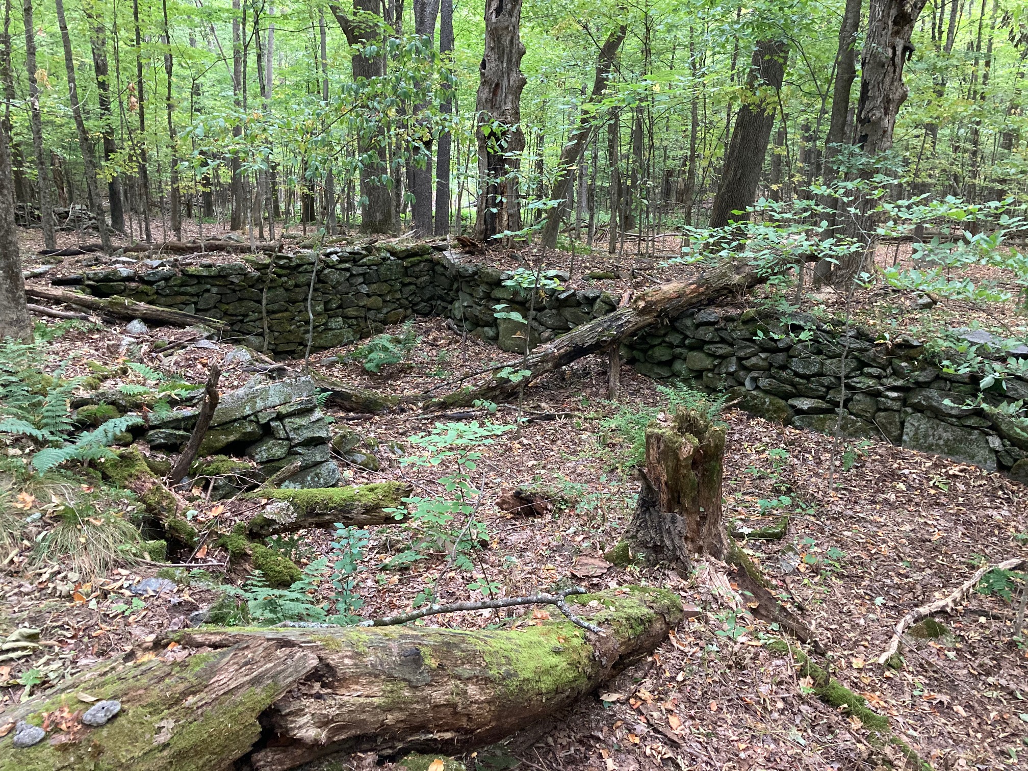
  • At Ruddsboro Road, a beautiful stone wall (the 13th or 15th?) creates a centuries-old hypotenuse between the roads. This scenic triangle has been protected by the Town of Hanover. It is part of nearby Mink Meadow Farm, home to a long-time Etna farm family. On one side of the historic Yankee-style barn is the foundation of an old silo – on the other, a tiny former milkhouse that now boasts refrigerated eggs and farm-grown vegetables.
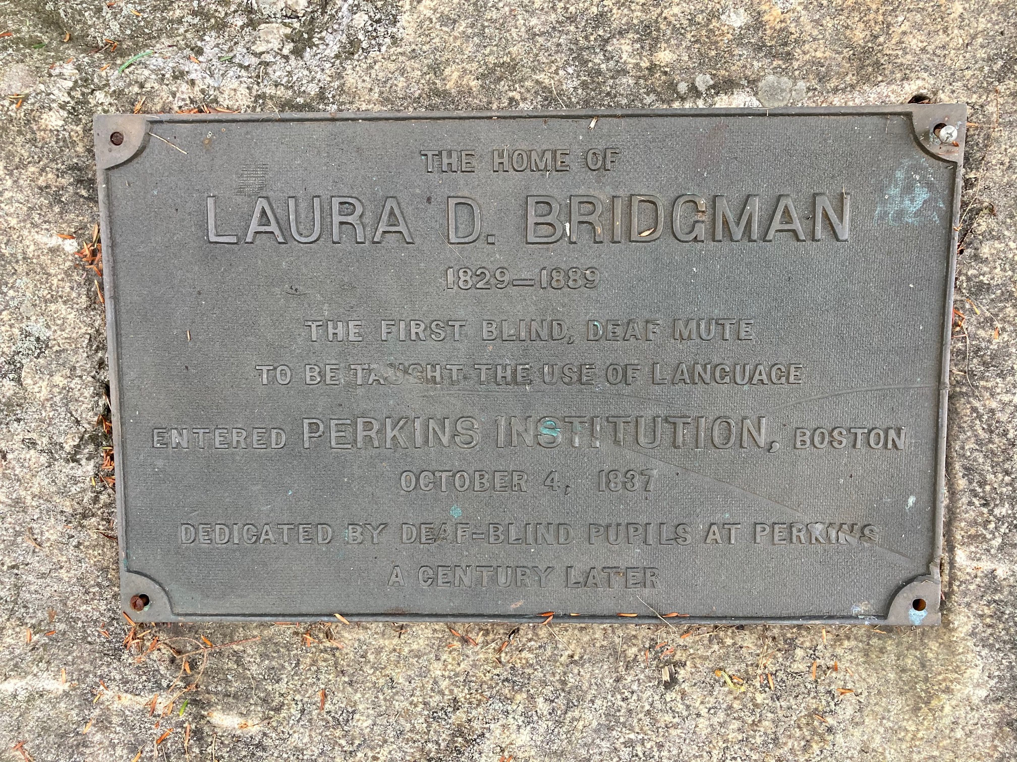
  • At R is the white 1767 Bridgeman House; the earliest part of this home is likely the middle section with the chimney. Take a moment to read the plaque mounted on the nearby stone. A tributary of Mink Brook passes behind the home and under the road.
  • Across the way, electric fencing excludes grazing cattle from the mainstem of Mink Brook, protecting water quality by allowing a lush buffer of native plants to grow along the stream to filter runoff. The farm family worked with the Connecticut River Conservancy to establish the fence and plant stream-side shrubs to keep the stream clean. For well over a century, waste from the entire village – including mill waste – was piped directly into the brook.
  • Don’t look now, but stone walls are everywhere in Etna village – among the most beautiful in town.
  • Pass the new fire station at R, and note the historic one ahead at L, a small gray clapboard building.
  • 10 minutes from the farmstand, arrive at Etna Library, one of only three structures in Hanover listed on the National Register of Historic Places. Turn into the parking lot and pick up the trail at the far end.
  • You’re entering Hayes Farm Park, acquired by the Town of Hanover in 2010 from the Hayes family whose farmstead and barn stand nearby at L.
  • Walk up through the meadow toward the kiosk. Glance beyond it at the impressive glacial erratic with early 19th century graffiti done by H. L. Huntington (for whom Huntington Hill takes its name). Take the R fork and continue straight through the meadow, up and around the corner, and through a gap in yet another stone wall. Here, the trail turns R and follows an early farm lane lined with beautiful high stone walls adorned by black, grey, and white lichens. How many tons of stone were moved to create the walls that stitch this rural landscape together? And all without machinery, just with man and animal muscle, patience, a good understanding of physics and gravity, and maybe not much else to do at certain times of year.
  • The path heads uphill to a fork marked by a sign indicating the King Sanctuary ahead and the path to Woodcock Lane to the L. Bear L as you gain the knoll – the wall makes the corner with you.
  • At L is a low cage protecting Trillium from deer browse. This is part of a deer monitoring project being of the Conservation Commission’s Biodiversity Committee. A few feet further stands a sign for the Audrey McCollum Trail. Stay L as the trodden path forks and follow Audrey’s Trail down into the woods, following yellow blazes. Bear immediately R on the needle-strewn path.
  • An ardent and well-known local conservationist, Audrey McCollum lived nearby on Trescott Road. Gifts in her memory allowed the creation of this trail in 2017.
  • Be sure to leash your dog here – porcupines den nearby!
  • Cross another stone wall and skirt the Trescott Wetlands on the somewhat rooty and rocky trail at the base of a dark hemlock and pine-covered slope. Contrast the stony hillside with the lush green ferny wetland at L. Audrey’s Trail goes over a few log crossings as you make your way around the wetland. Take care to stay on the trail and avoid nearby yards.
  • 10 minutes from the start of Audrey’s Trail, arrive at Woodcock Lane. Turn R toward the lane’s end and L at a sign just before the driveways. Be sure to keep your dog leashed, and please pick up after it.
  • This new section of trail was completed in September 2020 after much planning and effort by the Hanover Trails Committee. It provides a welcome path for “bird road” and other Etna residents to explore the natural parts of their neighborhood and to visit friends.
  • The pleasant yellow-blazed trail soon crosses a stone wall (watch your footing for wobblers) and enters the woods. Five minutes later the trail uses a log crossing near a small wetland that is likely a pool earlier in the year. This is a good place to look for animal tracks.
  • Turn L onto Partridge Road and enjoy the 8-minute stroll along this pretty lane. “Collect” your final stone wall at #3 Partridge, where a handsome historic wall has become a valued landscape feature for a later home.
  • Your car appears ahead, across Trescott Road.

This Hanover Hike of the Month has been generously sponsored by…

Filed Under: Hike of the Month, History, Hudson Farm, Invasive Species, King Bird Preserve/Hayes Farm Park, October, Trails Tagged With: stone walls

Butterflies For All

July 23, 2018

Come explore the lovely world of some of our local butterflies with Bill Shepard at the Etna Library on Monday, August 13th at 3:00.

Look at specimens and learn about moth & butterfly resources before heading outside to the Hayes Farm Park & Nan and Allen King Bird Sanctuary to try your hand at catching a few!

Crescent sp.

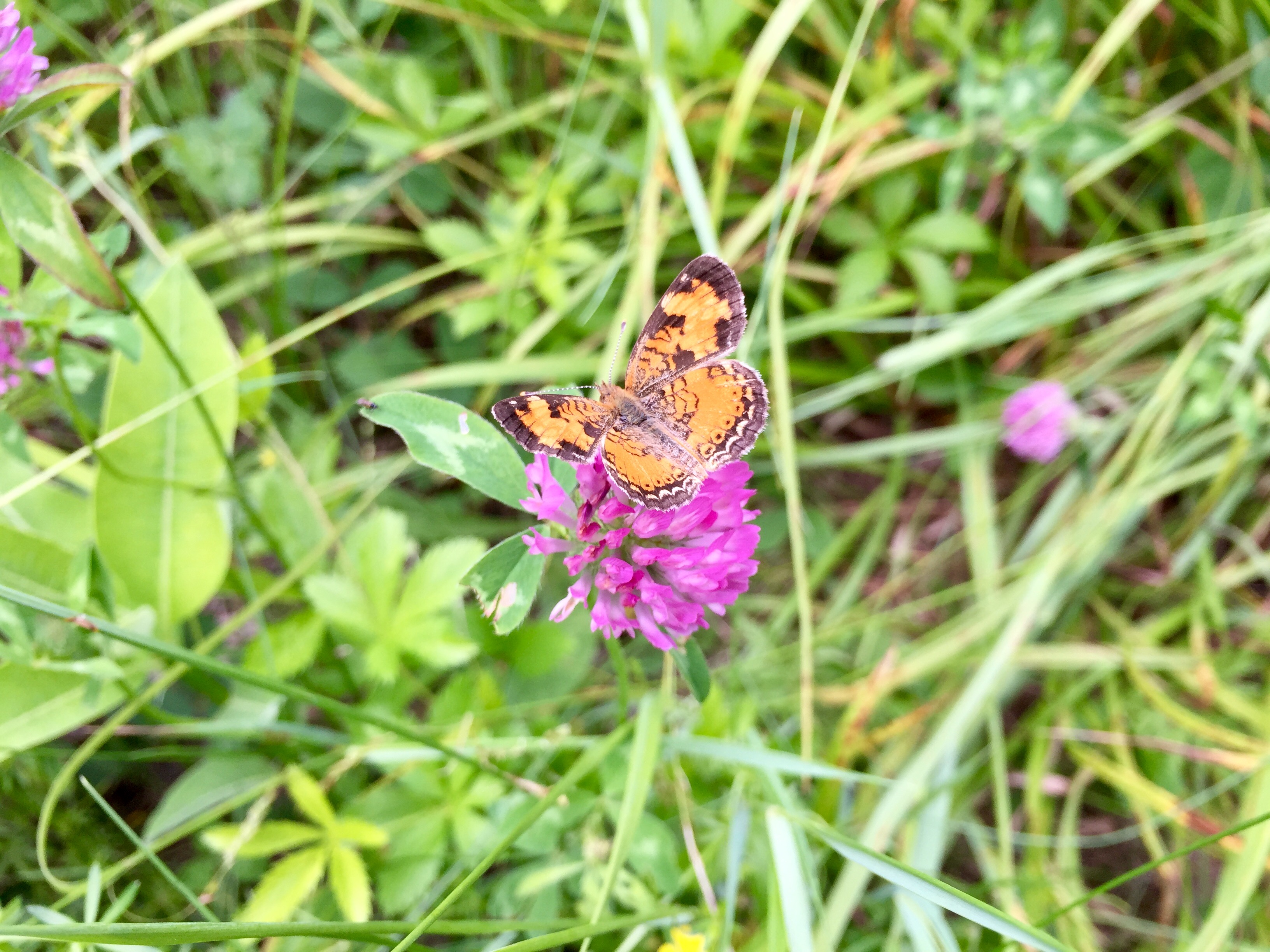
This fun & informative event is recommended for ages 8+, but all are welcome. Event includes a short, easy walk behind the library.

Filed Under: Events, Indoor Programs, King Bird Preserve/Hayes Farm Park, Outdoor Trips, Partnerships, Wildlife Tagged With: butterflies, Etna Library, family friendly, Hayes Farm Park, wildlife

Hayes Farm Park & Audrey McCollum Trail

May 1, 2018

Hayes Farm Hike – Full PDF


Hayes Farm Hike mapDriving Directions

  • This hike begins at the Etna Library at 130 Etna Road.
  • From downtown Hanover, follow East Wheelock Street up to Grasse Road, where it becomes Trescott Road. Continue straight on Trescott Road to Etna Road.
  • Turn L onto Etna Road and head N
  • Opposite King Road, turn L into the Etna Library parking area.

What You Should Know

  • Foot travel only. Dogs are welcome but must be under close control; please pick up after your pet.
  • While this hike is not long, there are some short steep sections and some tricky footing.
  • We suggest bringing a picnic and binoculars, and allowing extra time to enjoy this spot.
  • You are exploring land acquired by the Town of Hanover in two phases – the 12.9 acre Trescott Ridge Wetlands, set aside when the “bird roads” (Woodcock, Partridge, and Quail Lanes) were laid out, and Hayes Farm Park, 9.4 acres acquired from the estate of Ethel Hayes in 2010. On the way, you’ll visit the King Bird Sanctuary, established in 2011 by the Hanover Conservancy and the Audrey McCollum Trail, built in 2017.

Hiking Directions

  • Begin your hike at the sign reading, “0.5 miles to Woodcock Lane/0.2 miles to King Bird Sanctuary.” Head up the mown path toward the trailhead kiosk visible above the meadow.
  • erratic boulder at Hayes Farm park
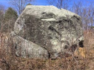
A massive boulder, looking quite out of place, looms ahead. This is a glacial erratic, plucked by the glacier from someplace northwest of here and unceremoniously dropped when the glacier receded, melting around it and leaving it behind. If you look closely, you can see that one H. L. Huntington spent quite a bit of time here on Sept. 14, 1872, carving the erratic’s first (and hopefully only) graffiti.
  • crabapple blooms
  • Pass L of the boulder and up into a small orchard of crabapples (L) that promise to be lovely at some point in May. Resolve right now to return to catch the show.
  • The trail is short and sometimes steep. Five minutes’ walk from your car, reach the top of a rise with the next of many fascinating features before you – a stone wall comes in at R. Close inspection reveals wide-mesh sheep fencing topped with a strand of barbed wire, clues that you are standing in what was sheep pasture (1820s-70s) and later pasture for cattle (to mid 20th century).
  • Continue down into the broad sheep lane with its fine stone walls on both sides. Halfway along, there’s a gap in the wall at R – your return route.
  • For a former sheep lane, this is a pretty interesting place ecologically. Here and there blue flags, set by the town’s Biodiversity Committee, indicate native plants to be tracked. Woodcock frequent the area, as do flocks of turkeys.
  • Follow the lane up the next knoll. A sign directs you R to the King Bird Sanctuary. The distinctive boulder seat, your next destination, appears up at L. It’s time for a picnic, or at least to pull out the binoculars!
  • King Sanctuary map
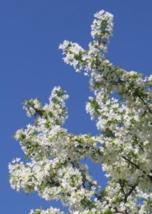
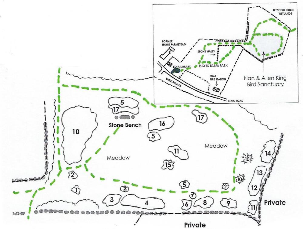
The Hanover Conservancy and Hanover Conservation Commission partnered to create this sanctuary to honor Nan and Allen King, prominent Hanover conservationists, and to benefit Etna Village. On the Upper Meadow of Hayes Farm Park, the sanctuary features a naturalized planting of hardy native trees and shrubs to benefit wildlife. It was dedicated on June 30, 2011, the Kings’ wedding anniversary. In addition to the Conservancy’s King Memorial Fund, many volunteers and donors helped make the project possible.
  • Worker clearing invasive plants
  • From your seat on the boulder, imagine this knoll as open pasture. A few such meadows can still be seen across the Mink Brook valley, but most have since grown up to pine. This piece was grazed longer and allowed to grow up more recently, with unforeseen and dire effects – what came in was not only white pine, but thick tangles of invasive non-native plants, including bristly Japanese barberry, honeysuckle, and glossy buckthorn. It took brave volunteers to cut the invaders and heavy equipment to pull them out by the roots.
  • Replacing them are plantings of native northern New England trees and shrubs that are more reliable and less demanding than exotic varieties, and provide better food, cover, and nesting habitats for native birds and other creatures. All of the plants displayed here are excellent alternatives for the home landscape. Look for tags identifying the plants, their value to wildlife, and ornamental qualities. You’ll want to visit the Sanctuary throughout the seasons to see the changing palette of flowers, fruits, and foliage, and to enjoy a quiet view of the birds and mammals who make this their seasonal or permanent home.
  • shadbush
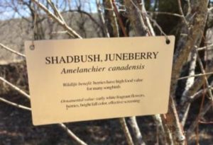
First up in spring are the delicate, fragrant white flowers of shadbush, also called serviceberry and Juneberry. Old-timers associated the blooming of this plant with the spring migration of American shad and also the time for burial services for those who died in winter when the ground was frozen. You’ll find three specimens of this small tree at the King Sanctuary. In June, brightly colored berries follow the flowers, attracting birds. In fall, it sports brilliant foliage.
  • Take a few minutes to explore the King Sanctuary and its plantings. Follow the mown path a few yards back down to an adjoining path, and at the first of three shadbush, turn L to follow the path along a stone wall. These beautiful walls, built 200 years ago to enclose the sheep pasture, are still enjoyed by animals. At this time of year they hold the spring sun’s welcome heat through the chilly night. You might find chipmunks, garter snakes, and other creatures taking advantage of their warmth.
  • After one wall opening (private property beyond) and a group of witchhazel, the wall takes a curious jog. Past a second, smaller gate, a clump of bushy young pines are all that’s left of the many that had invaded the abandoned pasture.
  • Bear L and take the path over the saddle of the hill, keeping the stone seat at L. The path bends down and L past the remains of a huge brush pile left from the culling of invasives and dead trees. Now it’s a handy home for small mammals.
  • Audrey McCollum headshot
    Audrey McCollum
  • You’ve encircled the small hill and, with another stone wall ahead, arrive at a sign for the Audrey McCollum Trail. An ardent conservationist, Audrey (R) lived nearby for many years. Gifts to the Hanover Conservancy in her memory allowed the creation of this trail linking the library to the Woodcock Lane neighborhood.
  • Turn R and head downhill, following sunflower yellow blazes and entering a cool hemlock forest. At this time of year you can find such fleeting evidence of micro-climate as lingering patches of snow and ice in the hemlocks’ dense shade, when the sunny Sanctuary had long since given up such wintry garb.
  • Nearing the forested Trescott Ridge Wetlands, the trail bears R and a dramatic stone wall angles down the hill at R. Step over the wall and turn R. This is good porcupine habitat – keep an eye on your dog.
  • The yellow-blazed trail skirts the E edge of the wooded wetland. Note the spongy green sphagnum moss and erect beaded fertile fronds of sensitive fern. Indeed, this place IS one huge sponge – it collects and stores meltwater and rainwater, releasing it slowly into a tributary of Mink Brook. Those living as far away as Greensboro Road benefit from the flood-moderating work of this wetland.
  • bog bridges
  • Approaching the north end of the wetland, you encounter a bog bridge of split logs to help you over a wet spot. A few yards further, cross an impressive string of carefully fitted planks bridging more wet areas and protecting wetland plants.
  • This is the work of the Upper Valley Trails Alliance with town and Conservancy volunteers who completed the Audrey McCollum Trail in 2017.
  • Follow the yellow blazes to avoid nearby private land. A final pair of bridges leads to the north end of Woodcock Lane. If you want to pick up the pace and cover more distance, you could walk down the lane, turn L onto Trescott Road (beware narrow shoulder), turn L onto Etna Road, and return to your car. We think it’s more fun to retrace your steps and see what you might have missed on the way out.
  • Turn around and follow the small stream feeding the wetland. It’s running well now, but slows to a trickle in summer. Signs of squirrel picnics might decorate a granite slab. Keep an eye on the blazes as you go.
  • stumps and logs along bog bridge
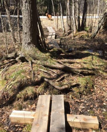
This is a very untidy environment! Mossy stumps, lumps, shrubs, standing and fallen trees create visual havoc but are part of what makes this such a valuable wetland. Note the silence of this place.
  • Keep the wetland immediately on your R until you reach the stone wall. Here, wildlife like mink use such places as billboards, placing scat where it can’t be missed.
  • Past the wall, the trail swings up and away from the wetland and, 15 minutes from Woodcock Lane, you ascend from the woods. Stay on the path and round the corner of the stone wall (unless the King Sanctuary’s stone seat requires another visit). Head down the broad sheep lane, past an impressive quartz boulder at R.
  • Turn L through the break in the wall and enter the field. Ahead, the old farm well-head gives the impression that a giant has pounded a tiny house into the ground. A cluster of flagging and fence posts indicates a population of plants being tracked and protected.
  • Pass the end of the tree line and follow the path as it turns R to bring you to the library and your car. Enjoy a fine view of the historic Hayes Farm barn. This farm was owned by the Ingalls family as early as 1855; by 1892, the Stetsons farmed here. Hayes family members still live nearby.
  • Before leaving, pay a quick visit to the lilac garden behind the Etna Library. This outdoor reading garden is encircled by lilac varieties brought by the Conservancy from the famed Highland Park in Rochester, New York, where Nan and Allen King met.

The Conservancy has prepared a map and guide to the King Bird Sanctuary plantings to help visitors learn more about the wildlife benefits and year-round ornamental values of these native plants. Copies are available at the Etna Library and Hanover Town Office.

Filed Under: Hike of the Month, King Bird Preserve/Hayes Farm Park, Lands, May Tagged With: shadbush, sphagnum moss, woodcock

Snowshoe Trek Through the Trescott Lands

December 29, 2015

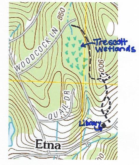
Sunday 1/24 – join us to explore the Trescott Water Supply Lands with those who are working to open these long-closed 1,165 acres to public recreation. MORE.

Thanks to KLG Financial Solutions for sponsoring this season’s schedule of free Conservancy adventures.

Filed Under: Forest Ecology, King Bird Preserve/Hayes Farm Park, Outdoor Trips, Slade Brook, Trails, Trescott, Wildlife

Birds at the King Bird Sanctuary

May 8, 2012

The crabapples are in full bloom, and the bird sanctuary’s new plantings are coming into flower and leaf for their first full season. Jim Block has shared some stunning photos taken at the Sanctuary in the last few days. Find them and more here!

Filed Under: Birds, King Bird Preserve/Hayes Farm Park

  • 1
  • 2
  • Next Page »

71 Lyme Road
Hanover, NH 03755
(603) 643-3433

info@hanoverconservancy.org

Facebook logo   Instagram   YouTube

Get Involved

Become a Member

Volunteer

Business Sponsors

Conserve Your Land

Employment

Our Mission

Advocacy

Conservation

Education

Stewardship

Explore Hanover

Hanover Hikes

Upcoming Events

Upper Valley Hikes

Trails Challenge

Copyright © 2025 Hanover Conservancy | Design by Chase Brook Software