Hanover Conservancy

Facebook logo   Instagram   YouTube          
Donate button
  • Home
  • About Us
    • Celebrating 60 Years
    • What We Do
      • Advocacy
      • Conservation
      • Education
      • Stewardship
    • Board & Staff
    • Membership Benefits
    • Contact Us
  • Get Outdoors
    • Hanover Lands
      • Balch Hill Natural Area
      • Mink Brook Nature Preserve
      • Other Properties
    • Hanover Hikes
    • Hanover Trails Challenge
    • Upper Valley Hikes
    • Exploring Nature at Home
    • Hunting
  • Events
    • Calendar
    • Spring Wildflower Scavenger Hunt
    • Private Events
  • Get Involved
    • Donate
    • Volunteer
    • Adopt a Trail
    • Corporate Conservators
    • Planned Giving
  • Education
    • School Programs
      • KAST
      • Connecticut River Studies
      • Hanover High School Scholarship
    • Request a Field Trip or Speaker
    • Research on Our Lands
    • Hanover History
    • Resources
  • News
    • Remembering Bob Norman
    • Reports & e-News
  • Conserve Your Land

Search Results for: route 120

Old & New Etna Loop

September 29, 2020

An easy to moderate hike among impressive stone walls on the oldest and newest trails in town.

Difficulty: Easy
Distance: 4.5
Elevation gain: 370
Time: 2.25 mile loop

Categories: Hike of the Month, History, Hudson Farm, Invasive Species, King Bird Preserve/Hayes Farm Park, October, Trails
Tags: stone walls

HIKE DIRECTIONS & MAP – Full PDF

Driving Directions

  • From Etna, take Trescott Rd northwest for 0.5 miles to the junction with Partridge Rd.
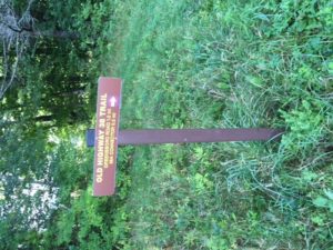
  • Park in the parking area on the L (W) side of the road at the blue sign reading “Old Highway 38 Trail.” If the area is not accessible, continue up Trescott Rd 0.4 miles to the AT parking lot at R, just before a fence at the Trescott Water Supply Lands.
  • Today’s hike is a loop through the Hudson Farm’s fields and forest on an historic highway, behind Etna village on the famed Appalachian Trail, and down Hanover Center Rd. to the Etna Library, the Audrey McCollum Trail, and Partridge Rd.

What you should know

  • This is a mostly easy hike with a few short steeper sections and some with tricky footing among roots or rocks. The route is well-blazed and signed.
  • The route follows an early road on one of Hanover’s newest conservation lands. In 2017, the Hudson Farm (brown-shaded area on map) was permanently protected as part of the Appalachian Trail corridor.
  • The Audrey McCollum Trail, built by the Hanover Trails Committee from Hayes Farm Park to Woodcock Lane in 2017, was extended in Summer 2020 to Partridge Lane to provide improved access to the central conservation area owned by the Town of Hanover.
  • Trails are maintained by Trails Committee volunteers.
  • Dogs are welcome but must be under your control and must be leashed on the McCollum Trail; please pick up after your pet.
  • Deer hunting is permitted (except at Hayes Farm Park) by archery Sept. 15-Dec. 15
  • Foot travel only; snowmobiles, ATVs, and bicycles are not permitted.
  • Please respect nearby private property.

BRIEF HIKING DIRECTIONS

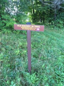
  • From the Hudson Farm parking area, take Old Highway 38 south to the rise in the meadow.
  • Turn R at sign for Old Highway 38 Trail and 38A Connector.
  • Stay straight at next trail junction; turn R at T toward Appalachian Trail.
  • Turn R (N) on AT, cross Trescott Road, and continue on AT to Hanover Center Road.
  • Turn R (S) on Hanover Center Road; follow to Etna Library.
  • Turn R into parking lot and take trail into meadow to junction with Audrey McCollum Trail.
  • Bear L onto Audrey McCollum Trail; follow this to Woodcock Lane.
  • Turn R onto Woodcock Lane and then L to new section of McCollum Trail.
  • Follow this to Partridge Road.
  • Turn L and walk along Partridge Road to Trescott Road; cross to reach your car.

FULL DIRECTIONS

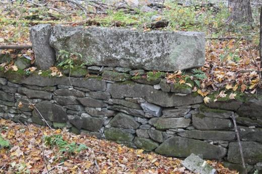
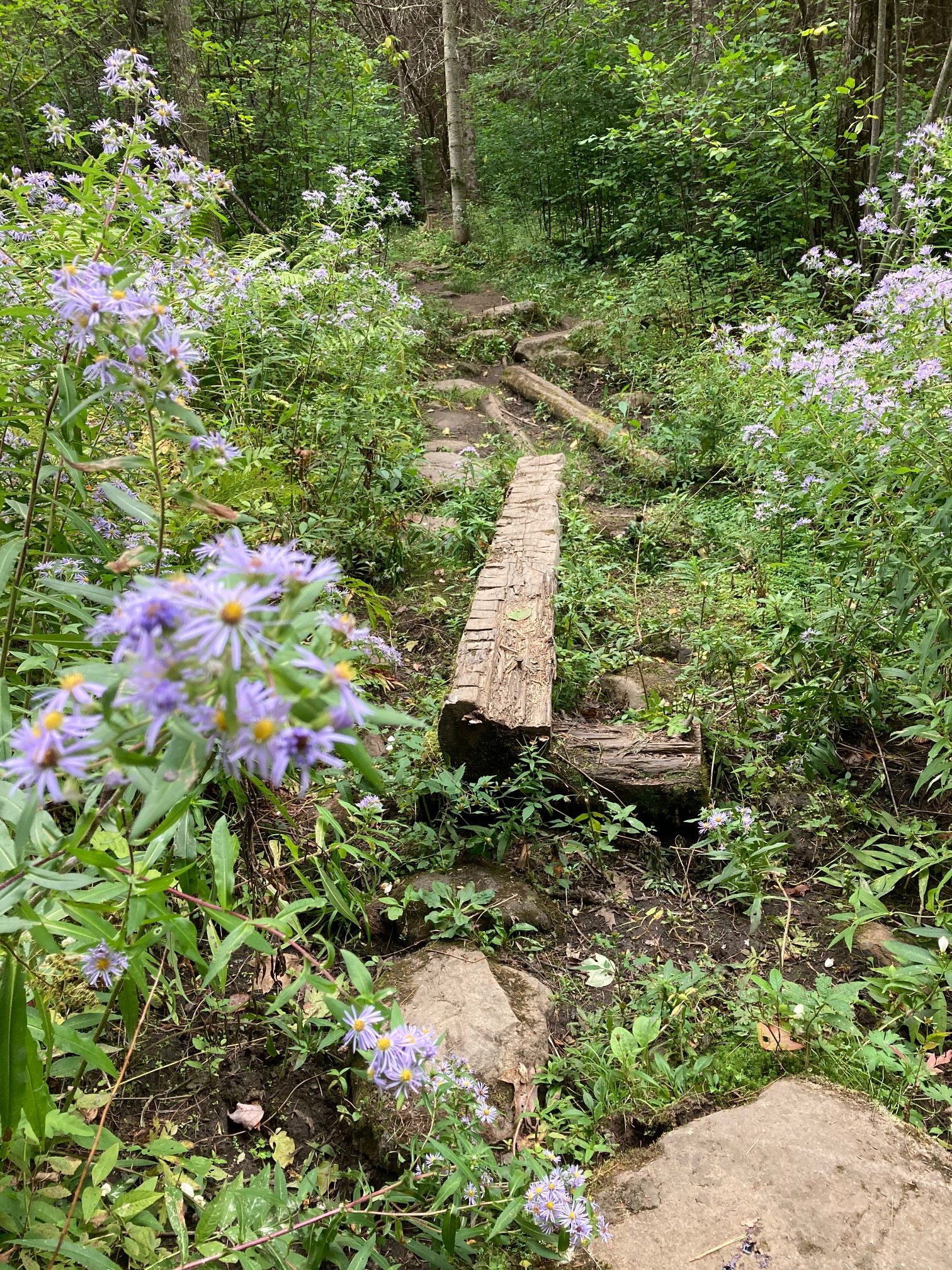
  • Begin your hike by passing the kiosk and taking Old Highway 38 along the treeline up to the rise that is visible from the trailhead. At this season, the old field is filled with nodding goldenrod, small white asters, and periwinkle New England asters. Start “collecting” stone walls! Among the leaves cloaking the hedgerow at L is the first, a low stone wall separating two former pastures of the historic Adams Farm.
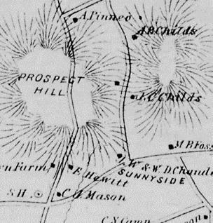
  • 5 minutes’ walk brings you to the top of the rise and a brown/yellow trail sign where two mown paths meet. Look back at R – easily visible is a white 20th century home built as a country retreat by retired architect Archer Hudson. Beyond another hedgerow stood the Adams Farm house from 1790 until 2024, a former tavern and home of the family that once owned the former farmland you are exploring now. Hudson purchased land that included the Adams barn – and then burned it down. Dartmouth College later bought the property and carved off his house for resale.  While the College referred to it as the “Hudson Farm,” the land ceased to be farmed when Hudson arrived.
  • In June, 2017, this was the site of a grand celebration. A partnership between the Trust for Public Land and the Town of Hanover, assisted by the Hanover Conservancy, resulted in the purchase of 175 acres by the National Park Service to permanently protect them as part of the Appalachian Trail corridor. In addition to major federal funding, many local contributions made this possible.  Owned for many years by Dartmouth, the property had been eyed as a site for everything from a cemetery and golf course to a housing development. Today, the AT Conservancy manages the land with help from the staff of the White Mountain National Forest.  The beautiful meadows are kept open by carefully prescribed burns, for their spectacular views and valuable grassland bird habitat.
  • Turn R at the sign to follow the Old Highway 38 Trail and pick up the 38A Connector. The trail heads down to the woods; crabapples at the edge, a remnant of farming days, bear colorful fruit at this time of year. Yellow blazes mark the trail.
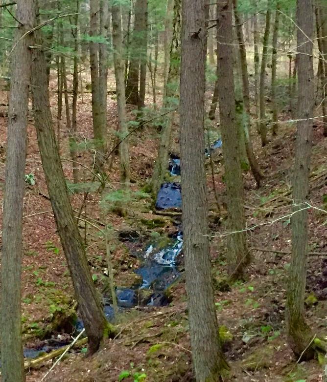
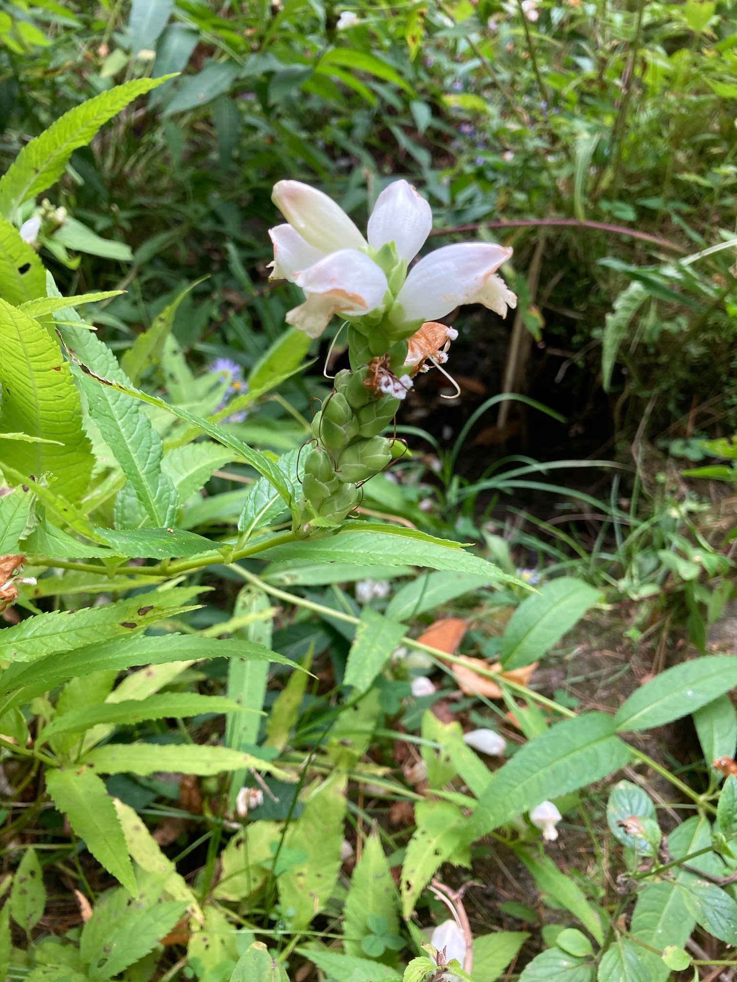
  • Two sets of boardwalks offer dry footing across a wetland, built by Hanover Trails Committee volunteers (thank you!). Protecting such headwater wetlands and streams from heavy foot traffic benefits water quality and trout habitat in Mink Brook below. The wetlands act as sponges during heavy downpours, holding water to prevent flooding and erosion in downstream neighborhoods. While they may seem dry at this time of year, the coarse fronds of sensitive fern are a clue to wetter times. Keep an eye out for the intriguing white flowers of turtlehead. 
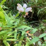
Their bee pollinators must muscle their way inside to gather their nectar.
  • Rising up and away from the wetland, you’ll soon see a pair of stone walls at R, reminders that this was once grazing land before the forest returned. The second turns a corner and follows the trail.
  • 7 minutes’ hike from the first trail sign, note another at L where Highway 38 turns L. You continue straight on the 38A Connector for 0.3 miles to the Appalachian Trail.
  • Head over stepping stones on what may be a dry crossing at this season. The trail is now blazed blue, indicating a, AT connection trail. The rolling trail moves through mixed woods in former pastures.
  • 5 minutes from the last junction, arrive at a T. Blue and white arrow signs in nearby trees (which seem eager to devour them) mark your R turn down the hill, following blue blazes. Mark the time – you’ll see why.
  • As you approach the clearly marked boundary of the old AT corridor – an 1800s stone wall, 1980s yellow blazes, and a 2017 boundary pin – you note that the forest understory is more open here. This land has a different history.
  • 10 minutes from your last turn, reach the pine-needle strewn crossing of the Appalachian Trail. It is easy to miss! The connector trail continues beyond the AT, bending around a yellow birch about 50’ ahead. Stop and look for the white blaze on a pine at R.
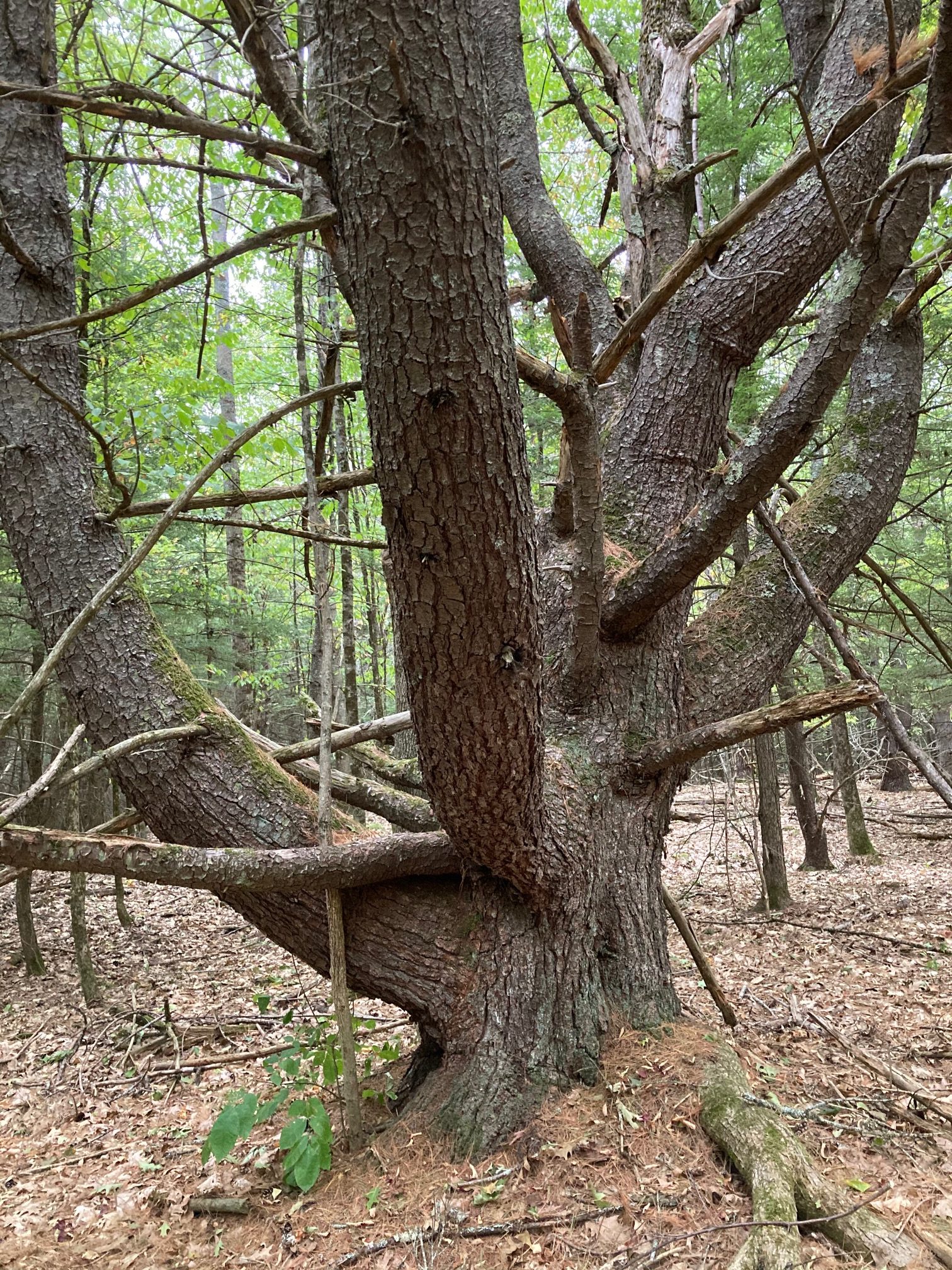
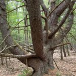
  • Turn R onto the famed – but here quite humble – Appalachian Trail, heading gently up for 7 minutes to the top of a low ridge. Stop here and note the big old “wolf pine” at L, a pretty impressive character. The growing tip of such a white pine was damaged early in its career, which let side branches develop into competing leaders. No longer valuable for timber, such pines were often left to provide shade for grazing animals – and to spook hikers.
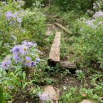
  • 4 minutes later, cross another small wetland decorated with asters and turtlehead.
  • On the far side, the forest understory is suddenly crowded with young buckthorn, an invasive tree. At this season, when most proper New England trees are beginning to shed their leaves or at least turn color, the non-native buckthorn reveals the secret to its grim success – it retains its green leaves and keeps on photosynthesizing well after the natives have checked out for the winter, giving it a competitive edge.
  • 4 minutes past the wetland crossing, arrive at Trescott Road. On the day we were out, during a drought, a thoughtful “trail angel” had left a cooler and big water bottle for thirsty hikers.
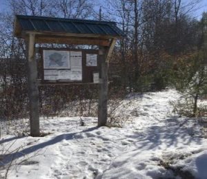
  • To continue on the AT, spot the trail across the road at one o’clock. A few steps in, a kiosk appears ahead. A path from the AT parking lot comes in at L, strewn with needles from the pine plantation it crosses.
  • Continue past the kiosk through thickly planted rows of pines, another part of the old farm that is now owned by the National Park Service.
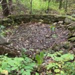
  • After a small opening, watch for an odd rectangular structure of moss-covered concrete at R – was this the farm’s spring house? A few steps further is a spectacular round drylaid stone structure – possibly the foundation of a silo. Etna’s farming history is deep and rich – and its footprints are everywhere.
  • 5 minutes from Trescott Rd, emerge into an opening where the trail skirts the upper edge of the recently reclaimed meadow. A stone wall (the fifth or sixth so far?) appears at R as the trail re-enters the woods. As you leave the Trescott Rd corridor behind, invasive buckthorn in the understory is replaced by native cherry, ash, and striped maple.
  • The AT crosses a low stone wall as you note many blowdowns. These may date from the 2007 Patriot’s Day windstorm that leveled much timber here and on the east slope of Balch Hill, among other places.
  • Cross another stone wall, this one remarkable for its long, angular slabs. Who knew stone walls had different personalities? We’ve only just begun!
  • Continue north on the AT as it rolls along, skirting the W edge of Etna village. Cross yet another stone wall.
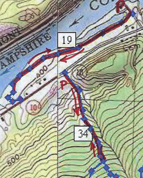
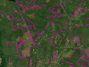
  • The trail bears L, arriving at an interesting intersection of stone walls that once must have divided pastures. The AT follows one on your L – note some venerable sugar maples lining it. As the trail rises, this wall becomes even more impressive, nearly reaching chest height. We can’t resist sharing here that in 1870, a government agency estimated that over a quarter million miles of drylaid stone wall had been built in New England and New York, most during a few decades in the early 19th century during the Sheep Craze. Recently, NH’s State Geologist has worked with area volunteers and UNH to create a citizen-based, on-line stone wall mapping tool using LiDAR maps. You can visit this site to see the stone walls you’re “collecting” on this hike (shown in pink on the image), and visit your own home area to see what other walls might exist nearby.
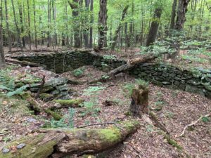
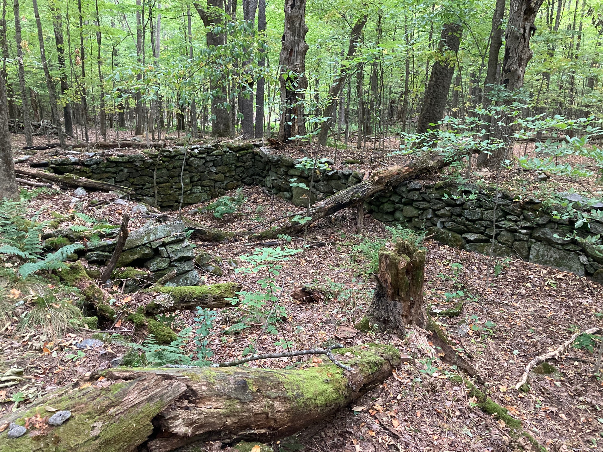
  • 5 minutes after crossing the last wall, you reach a height of land. A trail joins at R from the nearby neighborhood, and low wooden signs – along with a mystery object made of iron – invite you to stop and look around. Off just a few paces at L is a large and impressive cellar hole. It is the remains of another Adams farmhouse you’ve discovered. The Adams family once owned all the land between Dogford Rd and the E leg of Trescott Rd, over which you have been walking. When the farm was sold and subdivided to create the Trescott Ridge subdivision in the 1960s, Partridge Rd was re-routed and the Adams farmhouse (R) was removed – another piece of Etna history lost.
  • Continue straight on the AT, following white blazes to avoid a few cross-trails here. Within sight of the cellar hole, another wooden trail marker tells you to turn R; a brush pile blocks the incorrect path ahead. Add to your stone wall collection as you encounter more, many marked with old maples. Did these walls border a garden, a pasture, a cart path, a sheep pen, a lane, or were they just convenient places to store the stones?
  • 10 minutes past the cellar hole, descend toward a plush green wetland, startlingly green at this time of year. The spicy fragrance of drying hay-scented ferns is pleasing.
  • A plank crossing brings you over an often-dry streambed and the path twists toward an open field. On a summer morning, hawks may be hunting mice and other wee things from the perches above.
  • Just inside the meadow, the trodden path forks; bear R and skirt the old field through eye-high goldenrod before reentering the woods. The same dry streambed appears at L and you’ll soon cross it on a log bridge.
  • The trail passes behind the Etna cemetery, where many of those who built the walls and farms of Etna rest.
  • 7 minutes after entering the field, arrive at Hanover Center Road and turn R. A short, more civilized walk along the road gives a fresh view of the forested wetland you just passed.
  • Some of Etna’s most historic buildings – Trumbull Hall and the brick First Baptist Church of Hanover at L, and the former parsonage in the red cape at R – announce your arrival at what was once known as Mill Village, for the many mills that made busy use of the power of Mink Brook.
  • At Ruddsboro Road, a beautiful stone wall (the 13th or 15th?) creates a centuries-old hypotenuse between the roads. This scenic triangle has been protected by the Town of Hanover. It is part of nearby Mink Meadow Farm, home to a long-time Etna farm family. On one side of the historic Yankee-style barn is the foundation of an old silo – on the other, a tiny former milkhouse that now boasts refrigerated eggs and farm-grown vegetables.
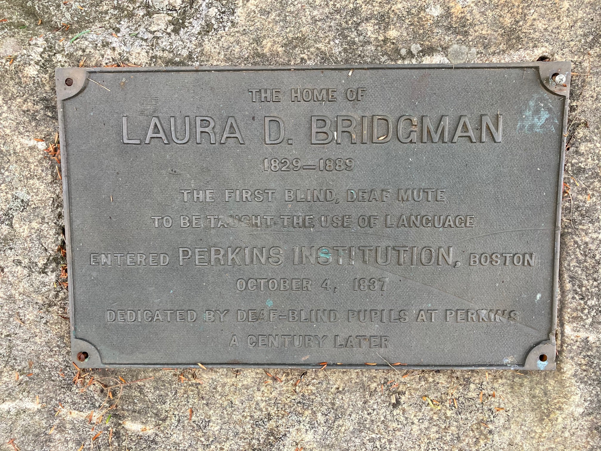
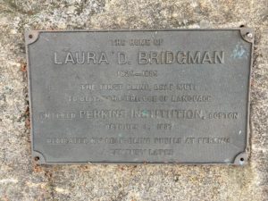
  • At R is the white 1767 Bridgeman House; the earliest part of this home is likely the middle section with the chimney. Take a moment to read the plaque mounted on the nearby stone. A tributary of Mink Brook passes behind the home and under the road.
  • Across the way, electric fencing excludes grazing cattle from the mainstem of Mink Brook, protecting water quality by allowing a lush buffer of native plants to grow along the stream to filter runoff. The farm family worked with the Connecticut River Conservancy to establish the fence and plant stream-side shrubs to keep the stream clean. For well over a century, waste from the entire village – including mill waste – was piped directly into the brook.
  • Don’t look now, but stone walls are everywhere in Etna village – among the most beautiful in town.
  • Pass the new fire station at R, and note the historic one ahead at L, a small gray clapboard building.
  • 10 minutes from the farmstand, arrive at Etna Library, one of only three structures in Hanover listed on the National Register of Historic Places. Turn into the parking lot and pick up the trail at the far end.
  • You’re entering Hayes Farm Park, acquired by the Town of Hanover in 2010 from the Hayes family whose farmstead and barn stand nearby at L.
  • Walk up through the meadow toward the kiosk. Glance beyond it at the impressive glacial erratic with early 19th century graffiti done by H. L. Huntington (for whom Huntington Hill takes its name). Take the R fork and continue straight through the meadow, up and around the corner, and through a gap in yet another stone wall. Here, the trail turns R and follows an early farm lane lined with beautiful high stone walls adorned by black, grey, and white lichens. How many tons of stone were moved to create the walls that stitch this rural landscape together? And all without machinery, just with man and animal muscle, patience, a good understanding of physics and gravity, and maybe not much else to do at certain times of year.
  • The path heads uphill to a fork marked by a sign indicating the King Sanctuary ahead and the path to Woodcock Lane to the L. Bear L as you gain the knoll – the wall makes the corner with you.
  • At L is a low cage protecting Trillium from deer browse. This is part of a deer monitoring project being of the Conservation Commission’s Biodiversity Committee. A few feet further stands a sign for the Audrey McCollum Trail. Stay L as the trodden path forks and follow Audrey’s Trail down into the woods, following yellow blazes. Bear immediately R on the needle-strewn path.
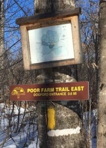
  • An ardent and well-known local conservationist, Audrey McCollum lived nearby on Trescott Road. Gifts in her memory allowed the creation of this trail in 2017.
  • Be sure to leash your dog here – porcupines den nearby!
  • Cross another stone wall and skirt the Trescott Wetlands on the somewhat rooty and rocky trail at the base of a dark hemlock and pine-covered slope. Contrast the stony hillside with the lush green ferny wetland at L. Audrey’s Trail goes over a few log crossings as you make your way around the wetland. Take care to stay on the trail and avoid nearby yards.
  • 10 minutes from the start of Audrey’s Trail, arrive at Woodcock Lane. Turn R toward the lane’s end and L at a sign just before the driveways. Be sure to keep your dog leashed, and please pick up after it.
  • This new section of trail was completed in September 2020 after much planning and effort by the Hanover Trails Committee. It provides a welcome path for “bird road” and other Etna residents to explore the natural parts of their neighborhood and to visit friends.
  • The pleasant yellow-blazed trail soon crosses a stone wall (watch your footing for wobblers) and enters the woods. Five minutes later the trail uses a log crossing near a small wetland that is likely a pool earlier in the year. This is a good place to look for animal tracks.
  • Turn L onto Partridge Road and enjoy the 8-minute stroll along this pretty lane. “Collect” your final stone wall at #3 Partridge, where a handsome historic wall has become a valued landscape feature for a later home.
  • Your car appears ahead, across Trescott Road.

This Hanover Hike of the Month has been generously sponsored by…

Filed Under: Hike of the Month, History, Hudson Farm, Invasive Species, King Bird Preserve/Hayes Farm Park, October, Trails Tagged With: stone walls

Childs Farm Loop at Trescott Lands

February 1, 2020

A short, easy hike on a new trail at the Trescott Water Supply Lands

Difficulty: Easy
Distance: 1.4 miles
Elevation gain: 180 feet
Time: 1 hour

Categories: February, Hike of the Month, Trescott
Tags: Wentworth, Wolfeboro Road, cellar hole

Childs Farm Loop full PDF


Childs Farm Loop trail mapDriving directions

  • From Downtown Hanover and the Green, drive E on East Wheelock St. and up the hill 1.7 miles to the junction of E. Wheelock, Grasse, and Trescott Roads. Continue straight on Trescott Rd. and
    drive 2.4 more miles to Etna Rd. Turn L and head N on Etna Rd. 1.3 miles to Dogford Rd. Turn L; follow 1.2 miles to parking on L after sharp bend and pond.
  • Park at the marked trailhead parking area near the kiosk.

What you should know

  • Today’s hike is a loop on lands owned by the Trescott Water Company (Town/Dartmouth).
  • This is a great route for confident backcountry skiers.
  • The route follows two 18th century roads, visits two cellar holes, and returns on a new trail (2019).
  • As of 2019, all trails described here are blazed with yellow and marked with brown and yellow signs, thanks to the Trescott Recreation and Hanover Trails Committees.
  • Dogs must be leashed while on the Trescott Water Supply Lands and waste must be picked up and
    carried out in order to protect drinking water.

Trescott trail kiosk in winterBrief Hiking Directions

  • Start on the Poor Farm Trail that begins at R of the trailhead kiosk.
  • The trail soon reaches an historic road; turn R and continue.
  • Follow the Poor Farm Trail E as it turns R off the old road.
  • Continue to Knapp Road and turn R.
  • Turn R on the Child’s Farm Trail for 0.6 miles and return to your car.

Trescott Water Supply Lands logoThe Full Story

  • Welcome to your water source! Drinking water for much of Hanover and Dartmouth College comes from these lands, so special rules apply for recreational use. Take a moment to check the kiosk display to acquaint yourself with these rules and pick up a trail guide.
  • Start at the path to the R of the kiosk; a few steps in, a sign at L identifies it as the Poor Farm Trail East, 0.6 miles to Knapp Road. The easy trail parallels Dogford Road before swinging R at a distinctly raised, flat spot that is the site of the old Wright place. Snow may obscure it today; the photo below gives you an idea of what you’re missing. Wright was raising sheep on this land in 1855; by 1892, J.W. and W.D. Chandler had taken over his farm.
  • stone wall in fieldAs the trail swings L again, note blue tubes on both sides of the trail. These protect young tree seedlings from deer browse. The foresters managing this land are working hard to re-establish native trees in a place with a dense deer population – the water supply lands had essentially been a deer sanctuary for half a century while people (and hunters) were fenced out. Deer prefer to browse the northern hardwoods like maple, birch, beech, and oak that make a healthy natural forest and therefore a pure drinking water supply. This is one reason why deer hunting is strongly encouraged on these lands.
  • Soon the path joins the wide old Wolfeboro Road, with its graceful stone walls and venerable sugar maples. Today, the Hanover emergency services folks insist on a different name to avoid confusion when attempting a rescue, so this section is now called Poor Farm Trail East.
  • Governor Wentworth portrait
    Governor John Wentworth

    Royal Governor John Wentworth ordered the cutting of this road in 1770 in hopes of traveling over it from his home in Wolfeborough, NH, to attend Dartmouth College’s first commencement in 1771. A committee of Hanover citizens was appointed to “…run a line from near the southwest corner of Hanover to the Great Pond, or Governor’s seat, at Wolfeborough, and view the situation of the land and convenience for a highway, and make return the first Monday in October next.” Members were paid four shillings and sixpence per day and spent ten days surveying the route. Hanover landowners were assessed a penny and a half per acre to raise the 120£ needed to complete the road. The road wasn’t finished in time, however, and the Governor had to travel by way of Haverhill to attend the first commencement, but by 1772 it was ready for the second ceremony.

  • Wentworth, appointed in 1766 by King George III to take over management of the colony of New Hampshire from his infamous uncle Benning, helped Eleazar Wheelock secure the charter for Dartmouth College. Here he appears as quite the dandy, but indeed he was an eager outdoorsman and leapt at any chance to go camping and rusticating in his colony’s abundant wilderness. While he was on the trail happily getting dirty and sleeping on the ground, his wife was planning her fancy ballroom at their estate in the Lakes Region.
  • Poor Farm Trail East sign
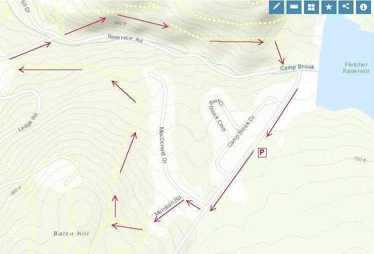
The Wolfeboro Road was probably only the second road in Hanover to be properly laid out, mapped, and recorded. Like many early roads, over the years its location has shifted. The entire road remained in use through the 19th century until construction of the Fletcher Reservoir in 1893 interrupted its path. Today many sections, including this one and the stretch that goes bravely up and over Moose Mountain, are Class VI roads. No wonder Emergency Services gets confused.
  • Follow the wide old road gently down the slope. A bit over 10 minutes from your car, your route swings R as the old road plunges toward what is now the Parker Reservoir, an area now off-limits to the public. Note the map posted on a tree at R. As you near the bottom of the hollow, birch tree trunk
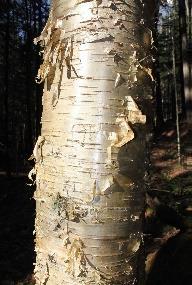
note the gleaming golden bark of yellow birch at R, a most handsome tree.
  • 20 minutes from your car, cross a stream headed for the Parker Reservoir. Pause to look upstream – at this season, with leaves off the trees, you get a good view of a well-laid stone wall running along the hillside above. One of Mr. Wright’s creations?
  • Climb up and out of the little valley. At the top, the trail bears L and flattens out.
  • At R note a plantation of small red pines, thigh-high at this writing. The Trescott lands experienced major blowdowns during the 2007 Patriot’s Day Windstorm, and two million board feet of logs and 3,100 cords of pulp were salvaged. This storm hit heaviest in the plantations, leaving natural stands largely unaffected. While the forest management plan for the Trescott lands calls for creating more natural, uneven-aged stands rather than even-aged plantations, this area is an exception to keep the slopes from becoming overrun by invasive buckthorn and other non-natives.
  • Proceed along the level trail, catching glimpses of Parker Reservoir below at L through the trees.
  • 30 minutes from your car, arrive at Knapp Road, identified by a sign just across the way and a map posted at R. Turn R and follow this historic road up the hill. Knapp Road was laid out Nov. 13, 1793, named for Lt. Peter Knapp of Hanover’s Revolutionary War-era militia. The cellar hole of his homestead is just below where this road meets another part of the Wolfeboro Road. In the late 1700s, that was a busy intersection!
  • A minute’s walk up the hill brings you to a sign at L interpreting the history of the Town Poor Farm, which once stood in the field beyond the road. That’s a great place to explore in spring.
  • middle school student group clearing brush
    Ms. Hadden’s 7th Grade group “Power of We”

    Continue to the top of a small rise and look for a small cellar hole at R in a circle of pines. Here is what seems like the remains of a very small house. Actually, most early homes had cellars under only a part, as a cellar was not easy to dig and was needed just for storage of apples and other supplies, not for the many purposes to which we put basements today. This was the home of P. W. Durkee in 1855, and by the 1880 census, government workers recorded the four Hewitts here – Elbert, 36 years old, a farmer; his 34-year-old wife Augusta, keeping house; their 12-year-old daughter Mary and 10-year-old son Charles, who both attended the District #4 one-room schoolhouse at the bottom of the hill. (Thanks to Ms. Hadden’s 7th grade group at the Richmond School, who researched this site and helped clear it of brush for their “Power of We” project in 2019.) In 1903, it was owned by Newton Frost until the Water Company bought his place and demolished it along with nine other farms.

  • Continue up Knapp Rd another 100 paces to a sign at R for the Childs Farm Trail. From here, it’s an easy 0.5 miles back to your car. Before turning onto the trail, look back down the road, noting the pines ringing the cellar hole at the edge of your view. This must have been a beautiful place to live.
  • Back to the mundane – is your dog still on its leash? There are porcupines nearby. Indeed, the next trail up the hill is named the Porcupine Trail for a good reason.
  • Childs Farm on old map
    1892 map showing Childs farm

    In the 1880s and 90s, the northeastern part of the Trescott lands were part of the home farm of Joseph Childs, his wife Christiane, and their children Arthur, Mabel, Myrtle, and Marcellus. Joseph was a major landowner with 500 acres, including a sugar orchard of 800 trees and an apple orchard of 200 trees, plus 10 cows, 12 horses, and 200 Merino sheep. The 1892 map at right shows Joseph’s location; he had set his son Arthur up in the next place north.

  • Strike out through the meadow on the Childs Farm Trail. The yellow-blazed trail is mostly flat and follows the contour, except where it dips when crossing a few small drainages. You’re now passing above the most recent plantation you saw from below, and have a better view of earlier plantings and a pine-backed ridge.
  • two men in tophats below a ram
  • 15 minutes after leaving Knapp Road, cross a second small stream and then climb gently to a small height of land. A low stone wall angles in at L; it may be barely visible in the snow. This is one of over a quarter million miles of stone walls built in New England and New York in the early-mid 19th century, largely in response to the rise of the Merino sheep industry (left). When the landscape-altering wool textile industry eventually went south, much of the human population went west, and the forest returned to cloak the hillsides where hundreds of sheep once grazed. In the mixed-age, mixed species forest surrounding you today, larger stumps are evidence of a previous harvest of trees that got their start a century ago.
  • 5 minutes later, you emerge into an open meadow that has been partly planted with young pines. At your appearance, finches erupt from feeding on seed heads in the scrub.
  • As your car comes into sight, a trail joins at R – a glance over your shoulder confirms it’s the Coyote Connector, an alternative route to Knapp Road.
  • As you approach the parking area, enjoy the view of Muscle In Your Arm Farm on the slope across Dogford Road, another part of the former Childs Farm. Its open sheep pastures, laced with stone walls lined with sugar maples, echo the view that you would have encountered a century ago on the lands you have just explored.

This Hanover Hike of the Month
has been generously sponsored byChase Brook Software logo


Filed Under: February, Hike of the Month, Trescott Tagged With: cellar hole, Wentworth, Wolfeboro Road

Camp Brook Valley Loop

October 1, 2019

An easy hike in the Balch Hill/Oak Hill neighborhood

Difficulty: Easy
Distance: 2 miles
Elevation gain: 270 feet
Time: 1.25 hours

Categories: Balch Hill, Hike of the Month, October
Tags: Oak Hill, Wentworth, Wolfeboro Road, aster, turtlehead

Trail Information and Hike Map – Full PDF


Camp Brook loop mapDriving Directions

  • From Downtown Hanover and the Green, drive E on E. Wheelock St. and up the hill 1.7 miles to Grasse Road. Turn L onto Grasse Road.
  • Park at the public ballfield parking area at 41 Grasse Road, outside the fence at the water treatment facility.

What You Should Know

  • Today’s hike takes you on a loop that tours the east and north slopes of the Balch Hill Natural
  • Area from neighborhood lanes and returns on the historic Wolfeboro Road, on lands owned by Dartmouth College and the Town of Hanover.
  • Dogs are welcome if under your control. Please pick up after your pet.
  • Archery season begins Sept. 15 and it is wise to wear blaze orange until Dec. 15.

Brief Hiking Directions

  • Turn L onto Grasse Rd to MacDonald Dr.
  • Turn R onto MacDonald Dr. and L onto Morrison Rd.
  • At far end of cul-de-sac, take steps up to trail
  • Turn R on the Garipay Trail
  • Take sharp R onto the Maple Trail
  • Turn L on Dot Strong Trail; at private drive, turn R
  • Turn R onto Reservoir Rd; cross to Wolfeboro Rd.
  • Take Wolfeboro Rd for 15 min
  • Turn R onto smaller path; cross brook
  • Turn L onto Reservoir Rd and Grasse Rd and return to your car.

The Full Story

  • Turn L onto Grasse Rd and walk along the shoulder past Camp Brook Dr. to MacDonald Dr. At this season, asters, goldenrod, and white-flowering turtlehead decorate the drainage ditch by the road. You might hear Canada geese announcing their flight south (let’s hope they didn’t linger on nearby Fletcher Reservoir).
  • Turn R at MacDonald Dr into a neighborhood developed for Dartmouth faculty and staff housing in the early 1990s. In fall, old apple trees hint at the history of this land, an orchard on the Garipay Farm.
  • 5 minutes’ walk from your car, turn L onto Morrison Rd and walk up the short lane to the cul-de-sac and trailhead sign.
  • Garipay Trail steps
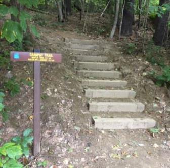
You can thank the Upper Valley Trails Alliance’s High School Trail Corps and the Hanover Conservation Commission for the friendly steps at the trail entrance. Built in 2019 on Grasse Rd Homeowners’ Assoc. land, they lend easy access to the Balch Hill Natural Area trail system.
  • It’s just a few paces to the junction of the Hunter East (L) and Garipay Trails. Turn R onto the blue-blazed Garipay Trail, named for the farm family that most recently owned this land. At this season, the many small drainages off Balch Hill are dry, but at wetter times of year, the wooden crossings are most welcome. The split log one was built by Hypertherm volunteers in 2019 and the lumber one by a Conservancy volunteer a few years earlier.
  • A low stone wall follows the trail at R; could this be a relic of the sheep days in the mid-1800s, when the entire hill was open pasture and orchard?
  • 5 minutes’ hike from Morrison, the Garipay Trail rises to meet the Maple Trail. Turning L would bring you to the summit with its beautiful views – if you have 10 minutes to spare, it’s worth the detour. For this trip, take the sharp R turn, cross the stone wall, and follow the yellow-blazed Maple Trail. You’re now on town land, bought from the Garipays in 1978 with help from the federal Land and Water Conservation Fund.
  • 2 minutes later, look for deer research plots at R. A small sign explains their purpose.
  • colored mushroom
  • Watch for color underfoot, not just among the maples overhead. It’s mushroom time!
  • 5 downed treesThe entire E side of Balch Hill suffered blowdowns from the Patriot’s Day Windstorm in 2007. At one point on the Maple Trail, you’ll see the “undersides” of 5 downed trees in a row, with their boles all pointing W away from the source of that wind. Eventually, the root masses will melt back into the landscape, leaving the “mound and pit” (sometimes called “pillow and cradle”) micro-topography typical of wind-influenced forests.
  • 10 minutes’ hike from the Garipay Trail, the Maple Trail enters more open coniferous forest and onto another piece of Dartmouth land, where the college kindly granted a trail license to move the trail onto a more sustainable path. By now you’ve gathered that the Hanover Conservancy, Hanover Conservation Commission, Upper Valley Trails Alliance, and Dartmouth are closely cooperating partners on Balch Hill.
  • A few minutes farther, look for a yellow Wildlife Safety Zone sign as the trail swings L and then out to the wide Dot Strong Trail. A glance to the R confirms this is a sewer line connecting two neighborhoods. Bicycles are allowed on the flat, comfortable path. Dot Strong was an ardent conservationist who lived nearby on Reservoir Road.
  • Turn L on the Dot Strong Trail and enjoy the easy 0.3 mile walk to Reservoir Rd. In 5 minutes, reach the metal gate posts at the edge of town property. Continue a few paces to the private drive at 29 Reservoir Rd (you’re allowed!), turn R down the drive, and note the trailhead sign at R – in case you’d like to try the loop counter-clockwise sometime.
  • Turn R onto Reservoir Rd. As you walk along the shoulder, look down into the forested ravine at L, listening for Camp Brook as it falls from the Fletcher Reservoir down to Storrs Pond. The brook has only this short distance to cool off in the shade of the hemlocks on its banks before reaching the pond. While smaller brooks run dry at this season, controlled releases from the reservoir keep water in the channel.
  • Cross the brook; look for the brown/yellow Wolfeboro Rd trailhead sign, just R of the Storrs Pond sign.
  • Take the Wolfeboro Rd trail up and around the metal gate. Five steps in, and you’re on the clearly discernable, original route of the Wolfeboro Rd. Our forebears chose a good path – it is safely out of the way of Camp Brook, which washed out Reservoir Rd a few years back.
  • Walk up through the hemlocks that shade the valley of this brook. You can imagine the relief of Royal Governor John Wentworth, after several days’ ride on the new road in 1772, as he made his final descent toward his destination, Dartmouth College’s second commencement. He had ordered the cutting of this road, linking his home in Wolfeborough with Hanover, two years earlier. At a public meeting on July 30, 1770, a committee of Hanover citizens was appointed to “…run a line from near the southwest corner of Hanover to the Great Pond, or Governor’s seat, at Wolfeborough, and view the situation of the land and convenience for a highway, and make return the first Monday in October next.” Members were paid four shillings and sixpence per day and spent ten days surveying the route. In October, they gained approval to lay it out from the College to the Canaan line. Hanover landowners were assessed a penny and a half per acre to raise the 120£ needed to complete the road.
  • The old road moves steadily up the side of the valley, past some large old pines that are still too young to have been here when the Governor passed through. Two Oak Hill trails join at L; continue straight.
  • At this season you can hear birds flitting in the branches overhead, preparing to join their migrating brethren following the nearby Connecticut River south.
  • 10 minutes’ hike from Reservoir Rd, the canopy opens up and the trail is crowded by young white pines eager to fill the space. This is your cue to watch for a less worn trail at R. (The Wolfeboro Rd continues with two detours through the Trescott Water Supply Lands, over Moose Mountain, and on to the Lakes Region.)
  • Turn R on this smaller path and head downhill for 5 minutes among the brash and brushy white pines. As you approach Reservoir Rd., note the barbed wire and sign on a big pine at L, marking the boundary of the restricted area around the Fletcher Reservoir and its dam. Just beyond at R are two study plots helping the Hanover Biodiversity Committee measure deer browse pressure on Trillium, a native wildflower. One plot is fenced from deer and the other, marked with blue flagging, is not.
  • Fletcher Dam construction in 1893A small footbridge leads over the natural channel of Camp Brook, nearly dry at this season, and soon you pop out on Reservoir Rd just as it curves into Grasse Rd. The Fletcher Dam looms above at L. Constructed in 1893, this is the first of two dams built on Camp Brook to provide safe drinking (and fire-fighting!) water to downtown Hanover and Dartmouth College. This image shows the many teams of horses and men employed in building the dam. We aren’t certain, but we believe that the white horses in the foreground are standing on what would eventually be flooded land behind the dam, and that the hill in the background topped by the tuft of trees is Balch Hill.
  • Follow Grasse Rd to return to your car at the public parking area just beyond the ball field and swings.

This Hanover Hike of the Month has been generously sponsored byJMH Wealth Management logo

October 2019 


Filed Under: Balch Hill, Hike of the Month, October Tagged With: aster, Oak Hill, turtlehead, Wentworth, Wolfeboro Road

Fullington Farm & Old Highway 34

December 1, 2017

Do one or both – a gentle path along the river and a quick hike up an historic road.

Difficulty: Easy
Distance: 1.8 miles
Elevation gain: 240 feet
Time: 1 hour

Categories: December, Hike of the Month
Tags: Class VI Road, Fullington Farm, Highway 34, merganser

Hike Directions and Trail Map – Full PDF


Fullington Farm hike mapDriving Directions

  • From Downtown Hanover, drive N on N. Park Street and turn R onto Route 10N.
  • Drive past the golf course, through a rotary, past the Richmond School, and through a smaller rotary.
  • Continue 1.5 miles past the smaller rotary on Route 10 and turn L at the entrance for Wilson’s Landing.
  • Park in the gravel-surfaced lot next to the Connecticut River. Sunset is an especially lovely time for a walk on the river path, but give yourself plenty of daylight if you plan to hike Old Highway 34.

What You Should Know

  • You can opt to explore just the gentle path along the river, the more challenging Old Highway 34, or both to get a fuller sense of the variable character of Hanover’s Connecticut River corridor.
  • You’ll be walking on lands owned by the Town of Hanover, Friends of Hanover Crew (briefly) and Dartmouth College. Conservation easements protect some but not all of this land.
  • Dogs are welcome but must be under your control; please pick up after your pet. You will need a leash.

Hiking Directions – Fullington Farm River Path

  • Begin at Wilson’s Landing. This town-owned public river access area is named for Wilson Fullington, one of a family of riverfront farmers who worked this fertile land with its ample gambrel dairy barn. That property and 2.4 acres of land are now owned by the Friends of Hanover Crew.
  • Before starting your hike, walk to the water’s edge. From here, you enjoy a splendid view up the mighty Connecticut, the largest river in New England. This area is the scene of many regional crew races on the flat water impounded by Wilder Dam, a few miles downstream. When leaves are off the trees, flat-topped Smarts Mountain in Lyme appears on the horizon to the N. The Hanover Conservation Commission recently led an extensive effort to improve the public boat landing here, adding picnic tables, comfortable benches, a dock, improved boat launch, and timber-framed information kiosk.
  • The flooding of this area by Wilder Dam in 1950 changed the shoreline, and this is a great place to look for waterfowl in the quiet backwater and for smaller birds nesting in the shrubby growth nearby. At this season the slender cattails are dispersing their seeds and look like they’re wearing shaggy fleece coats. You can admire the festive scarlet twigs of red osier dogwood – there’s a good clump next to the boat landing. This native New England shrub, which grows well in wet places, is highly valued by wildlife for its nutritious white berries. You won’t see those because they don’t last long!
  • Leave your car and walk back up the gravel drive as far as the sign at R indicating that this land is protected by the Land Conservation Investment Program and the Trust for NH Lands. This was New Hampshire’s first venture into conservation on a state-wide scale, authorized by the Legislature in 1987, which appropriated $25 million that was spent (with $3.3 million of private funds) to protect over 100,000 acres of much appreciated land before the program closed in 1993. The Huntington Hill lands nearby in Hanover were also protected through this program. The Hanover Conservancy, then known as the Hanover Conservation Council, led a fund-raising campaign for the local match. The land remains privately owned but is now protected by a permanent conservation easement held by the Town.
  • merganser in flightEnough talk, let’s walk! Turn R off the drive and onto the mown path just before the gravel path leading to the crew boathouse. Turn S along the river. For the next few minutes you’ll have a good view of the backwater, where dabbling ducks and other waterfowl shelter in this quiet area off the mainstem, especially during the fall migration. The Connecticut River is a major migration corridor for these and other birds. On the afternoon we walked this path, the lowering sun lit the white breast of a migrating common merganser, its rapid wingbeats echoing the intent of its outstretched neck as it flew south, low and fast, over the water. (R – male in flight)
  • Meadowsweet, goldenrod, and other rough herbs and shrubs grow near the bank, along with sumac, red and silver maple. This riparian buffer helps capture any sediment in the runoff from the fields that might be headed toward the river. Common among them is invasive honeysuckle, easily picked out with its scrappy bark, low arching branches, and opposite buds. This shrub is especially obvious around the gullies and cavities in the bank at the bottom of the field.
  • About 8 minutes into your walk, pass through a gap in a hedgerow marking the boundary of a larger field. You’re in a world apart – while you can hear the sounds of cars on Route 10 above and Route 5 across the river, your view is much more wholesome – all rolling fields and river. The rich soils under the sod, a gift of the river, are among the most fertile in the country. Indeed, they are among the most valuable agricultural soils in Hanover.
  • The mown path curves R around a gully; glance to the N for a nice view of Smarts Mountain and the point of wet land extending downstream from Wilson’s Landing (when leaves are off the trees).
  • Soon the big white barn of the Dartmouth Organic Farm comes into view above at L, along with the low building now housing the Hampshire Cooperative Nursery School. These are the current uses of what was the last dairy farm of any significance in Hanover – the Dartmouth Dairy, also known as the Fullington Farm. Four generations of Fullingtons worked this land, most recently with a milk processing and bottling plant run by Haslett Fullington and his brother, Wilson. Their fleet of trucks delivered milk produced by their herd of Guernseys to the college and beyond. Dartmouth bought the property in 1972.
  • 1892 Fullington area map
    1892 map of the area

    The Fullingtons had been on the land since at least 1860, and lived in the c. 1820 cape house that stood near the large and handsome early barn. In 1885, the Grafton County Gazetteer listed William Fullington as farming 220 acres with 300 head of registered Merino sheep and a sugarbush of 120 maples. The College tore down the nearly 200-year-old farmhouse in the summer of 2017. (R- 1892 map of the area)

  • Today, your path passes an experimental planting area, bee hives, and a nursery of evergreen and deciduous trees on the fields where the Fullingtons once grew feed for their cows or pastured their sheep. The path approaches the south boundary where a gravel drive curves up to Route 10. You can walk back to your car along the road, but it’s more fun to retrace your steps and head north on the mown path along the river.
  • As you do, note the sole many-stemmed tree standing nearby on the riverbank, a sole representative of the grand and towering silver maple floodplain forest that once blanketed the riverbottom here – after the glacier left but before European settlers cleared the alluvial plains for farming, before the Smiths and Fullingtons, and before Wilder Dam inundated the shoreline. Silver maples tolerate flooding and are supremely adapted to such a setting.
  • As you return N, the pine-studded crest of an esker looms beyond the barn roof. This is part of a ribbon of sand left behind by melting water under the glacier as it covered this area thousands of years ago. You can explore another piece of this geological ribbon at the South Esker (Hanover Hike of the Month, August).
  • The low sun of the approaching winter plays tricks as you walk N along the river. Your shadow reaches forty feet ahead and the light reflects off the river, illuminating golden brown oak leaves still clinging to their branches. Oaks are thought to have evolved in the south and never developed the knack of dropping their leaves in fall as those of northern maples and birches do.
  • Pass through the hedgerow and enjoy a fine view of the beautiful white dairy barn.
  • It appears that both the old farms you pass on this walk have been present for centuries – no surprise given their desirable soils. Just north of the barn, a fine two-story farmhouse stood from 1771 until it was torn down in 2018. Historic maps indicate that this riverfront farm was occupied by one I. Smith in 1855 (when the Fullington Farm was owned by a B. Tisdale), and in 1892 by F. W. Smith. We’re guessing that the Fullingtons bought their neighbors’ place sometime around 1910 to make room for a son and his family, updating the old Smith farmhouse with a generous front porch.
  • Turn L toward the boat landing and back to your car. Resolve to return for a family picnic by the river!

Hiking Directions – Old Highway 34

  • If you have another half hour and energy to spare, cap off your adventure with another hike into the past. If it is hunting season, you’ll want to dress in fashion – blaze orange.
  • You can either walk or drive to the nearby trailhead. Return to Route 10, turn R and then L up a short gravel drive. This leads to an unmarked parking area N of the flat old river terrace that today sees less action from glacial Lake Hitchcock and more from soccer players. In winter, trucks deliver snow plowed from downtown streets to this spot, allowing it to melt into the ground close to the river where any contaminants mixed with the snow cannot interfere with drinking water wells or the river directly.
  • Walk around the green metal gate across the entrance to the old road. In 1794, Highway 34 ran “from Ezra Carpenter’s on the Wolfeboro Road to Elias Newton’s on the River Road” (meaning Route 10). Its S end continues as Grasse Road linking Reservoir Road to Trescott Road. In 1979, Town Meeting voted to discontinue the N part subject to gates and bars such as this one. The Town still owns the right of way.
  • You’ll soon reach signs indicating the college’s shooting range; the old road probably passed through that area. Instead, you will turn R, away from the range, and skirt the L edge of the field, hiking uphill. The college’s sugarhouse is visible at R. Does the sap from William Fullington’s 120 maples boil there?
  • When the nursery school is in session, this area becomes an outdoor classroom. It looks like fun!
  • unnamed brook in Fullington areaNo more than 5 minutes from the gate, the narrow historic road becomes evident again, passing straight up into the woods. It climbs steadily on the R side of a narrow little valley, heavily wooded with large hemlocks and white pine. One can only imagine the strength required of a farm horse to draw a laden wagon up this hill. The remains of an old stone wall appear at R, confirming the nature of the old way. An unnamed stream tumbles down the hillside at L through a shaded and undisturbed valley. It’s the clear waters of small, cool, well-oxygenated streams like this that provide relief for fish in the Connecticut River below.
  • 10 minutes from the lower gate, you’ll reach another one. This is your turnaround point today. Pause to note a lovely small waterfall at L (photo). At R is undeniable evidence that the forest beyond was once the Fullingtons’ diligently maintained pasture – many strands of barbed wire still attached to the stump of a long-dead tree.
  • At this point, Highway 34 bears gently R and enters a maze of trails on Oak Hill before it ends at Reservoir Road, 1.8 miles from your starting point. That’s a challenge for another day.
  • Return to your car, enjoying the gentle conversation of the brook and wondering, as we do, why it never earned a proper name. We think it should be Fullington Brook.

December 2017, updated August 2020

Filed Under: December, Hike of the Month Tagged With: Class VI Road, Fullington Farm, Highway 34, merganser

Historic Wolfeboro Road West

June 1, 2017

An invigorating hike on Hanover’s most historic road, visiting three cellar holes and an unusual viewpoint.

Difficulty: Medium
Distance: 2.8 miles one way
Elevation gain: 600 feet
Time: 2 hours

Categories: Hike of the Month, June, Trescott
Tags: Wentworth, Wolfeboro Road, cellar hole

Wolfeboro Road West – Full Hike PDF


Wolfeboro Road trail map
Route is outlined in green

Driving Directions

  • Arrange with a friend to leave a car at the hike’s end OR give yourself time to hike back to your car.
  • Car drop: from downtown Hanover and the Green, take E. Wheelock Street east up the hill; continue as it becomes Trescott Road. Turn L onto Etna Road. Drive through Etna village, pass a cemetery on L, and turn L onto Dogford Road. Follow as it turns sharply R past a farm pond; turn L into the Trescott parking area. To reach the start point, return to Trescott Road and turn R onto Grasse Road. Follow as it turns L and heads down the hill. Stay R for Storrs Pond and Oak Hill. Park at the Oak Hill parking area at R.
  • Starting point for a round trip hike: from downtown Hanover and the Green, take the Wolfeboro Road (known today as College Street) north through campus past the medical school. At the Dewey Field light, stay straight to join Lyme Road. Drive past the golf course to the rotary and bear R onto Reservoir Road (still on the old Wolfeboro Road route). Turn sharply L toward Storrs Pond and Oak Hill as the road enters the woods. Park at the Oak Hill parking area at R.

What You Should Know

  • Trescott Water Supply Lands logoWelcome to your water source! Most of this hike crosses the Trescott Water Supply Lands. Drinking water for much of Hanover and for Dartmouth College comes from this area, so special rules apply for visitors.
  • Dogs are welcome but must always be leashed; please pick up after your pet.
  • You may encounter forestry vehicles; they have the right of way.
  • Hiking times are approximate. Plan on 2 hours; longer if you plan to spend time enjoying the views.

Hiking Directions

  • Begin your hike by walking back up the lane to a path entrance between the white Storrs Pond sign and the green street sign for Reservoir Road. Five steps in, and you’re on the clearly discernable, original route of the Wolfeboro Road. Our forebears chose a good path – it is safely out of the way of Camp Brook, which washed out Reservoir Road a few years back.
  • Walk up through the hemlocks that shade the valley of this brook. You can imagine the relief of Royal Governor Wentworth, after several days’ ride on the new road, making his final descent toward his destination, Dartmouth College’s second commencement in 1772. In hopes of making it to the first one, Governor Wentworth ordered the cutting of the Wolfeboro Road, from his home in Wolfeborough across to Hanover, in 1770. At a public meeting on July 30 of that year, a committee of Hanover citizens was appointed to “…run a line from near the southwest corner of Hanover to the Great Pond, or Governor’s seat, at Wolfeborough, and view the situation of the land and convenience for a highway, and make return the first Monday in October next.” Members were paid four shillings and sixpence per day (Hanover Center’s Jonathan Freeman earned six shillings and sixpence/day as surveyor) and spent ten days surveying the route. In October, they gained approval to lay it out from the College to the Canaan line. Hanover landowners were assessed a penny and a half per acre to raise the 120£ needed to complete the road.
  • portrait of John Wentworth
    John Wentworth
    Royal Governor John Wentworth, appointed in 1766 by King George III to take over management of the colony of New Hampshire from his infamous uncle Benning, helped Eleazar Wheelock secure the charter for Dartmouth College. Here he appears as quite the dandy, but indeed he was an eager outdoorsman and leapt at any chance to go camping and rusticating in his colony’s abundant wilderness. While he was on the trail happily getting dirty and sleeping on the ground, his wife was fixated on having a fancy ballroom at their country estate in Wolfeborough.
  • In about a half mile, just as the road starts gently downhill, look R for a trail coming in from Reservoir Road where it joins Grasse Road. If you want to return to this side of the Trescott lands, you can park at the ball field near the water filtration plant and take this path over a foot bridge.
  • You are near the foot of Fletcher Reservoir, first of two impoundments built on Camp Brook to provide water to downtown Hanover and Dartmouth College. This reservoir flooded a section of the Wolfeboro Road, so we will bear L and head uphill to avoid this section and the protected area around it. Because the public is not permitted within 250 feet of the waters, we’ll have to take a few side trails, but these are not without their delights!
  • After six minutes’ walk from the trail junction, a mowed ski trail comes in from the L. A few yards further, look closely for the turn to the R as the ski trail veers off to the L – your goal is a sign, posted a short way into the woods at the Trescott Lands boundary. Time to leash your dog, if your pup is along for the hike.
  • This trail takes you over an old woods road and soon, a newly built bridge over an intermittent stream. The trail is marked in most places with flagging and is well trodden, following the contour of Stone Hill (more about Stone – a person, not a geological feature – in a moment). Side trails built by mountain bikers come in at L in several places; avoid these and stay on the generally straight path.
  • Soon, you’ll see a stone wall ahead. Head for the break in the wall and emerge from the forest to a vantage point. This unusual view of Velvet Rocks, with the waters of Fletcher Reservoir at R, is your reward for the detour off the old road.
  • Head downhill, following stakes in the open field, to rejoin the Wolfeboro Road at a well-marked opening in the trees. Look R to see where the old road went west, and turn L to resume your pilgrimage. Red boundary signs on the R and orange blazes on trees indicate the reservoir buffer, not open to the public (or dogs hoping for a swim).
  • Walking on the old road is easy and grades are gentle. Keep your eyes out for the cellar hole at L of the old Stone Farm, on a small rise (double circle on the map). Plans to dam Camp Brook meant that farmers in its watershed would be displaced. In 1893, Dartmouth College simply swapped farms with Charles Stone. It’s said that he milked his cows here in the morning of the move, then herded his cows down the Wolfeboro Road and through downtown Hanover, and installed them in their new barn near Mink Brook just south of town, where he milked them that evening.
  • Continue east on the Wolfeboro Road to Mason’s Four Corners. Now a log landing, the Four Corners was once a major intersection where the Wolfeboro Road crosses the more recent Knapp Road. Look for a sign posted on a tree opposite, confirming your location.
  • Knapp Road was laid out Nov. 13, 1793, named for Lt. Peter Knapp of Hanover’s Revolutionary War-era militia. The cellar hole of his homestead is on the northeast corner of this intersection. By 1855, J. J. Mason lived here, followed by Charles Mason by 1892. The 160-acre Mason Farm had a 100-tree apple orchard and 200-tree sugarbush. Mason also kept 12 dairy cows and 70 Merino sheep. In the days before the Civil War, Hanover was one of the four top sheep towns in New Hampshire (after Walpole, Lyme, and Lebanon). The water company purchased Mason’s farm by 1903 for $4000.
  • At the NW corner of this intersection stood the one-room District #4 schoolhouse (1807). Look for an interpretive sign here for more about these historic sites.
  • The Wolfeboro Road was probably only the second road in Hanover not only to be properly laid out but also to be mapped and recorded. Like many early roads, over the years its location has shifted, with and without the benefit of surveys and deeds. The entire road remained in use through the 19th century until construction of Fletcher Reservoir in 1893 interrupted its path.
  • As a member of Dartmouth’s new Board of Trustees, Wentworth hoped to cross it for the first commencement of four students in 1771, but not all the communities in its path felt obliged to cooperate in its construction (except Hanover, of course!). It wasn’t ready for another year, and was still just a rough trace, not a “road” as we imagine it. In 1771 the governor ended up going by way of Haverhill.
  • The Wolfeboro Road continues E, still marked by old sugar maples but obscured by brush. Here again, we must take a detour to avoid the reservoir buffer, this time for the Parker Reservoir. After imagining the busy neighborhood that once existed here, continue up Knapp Road, itself lined with stately old maples and stone walls. In a few minutes you’ll notice another sign at R for the trail to Dogford Road. Turn R here.
  • The hillsides beyond are partly open and are being replanted. These lands experienced major blowdowns during the 2007 Patriot’s Day Windstorm. Two million board feet of logs and 3,100 cords of pulp were salvaged. This storm hit heaviest in the plantations, leaving natural stands largely unaffected. The forest management plan calls for creating more natural, uneven-aged stands rather than even-aged plantations.
  • Catch glimpses of Parker Reservoir as the trail turns SE to rejoin the old Wolfeboro Road after a short dip.
  • Back to Royal Governor John Wentworth – he visited Hanover for the third and last time in 1773, once again for the College’s commencement exercises, presumably traveling over his new highway. He was not able to attend in 1774, and by the summer of 1775 he had fled New Hampshire after war broke out with Great Britain.
  • Back to the mundane – is your dog still on its leash? Give yourself a gold star and know that there are porcupines nearby.
  • stone wall in fieldTurn L, uphill, returning to the old road. It climbs gently but steadily, and stone walls become more impressive. You’re seeing the handiwork of one Wright, who owned the farm at the final cellar hole we will visit today. He was there in 1855; by 1892, J.W. and W.D. Chandler had taken over his farm. As the gate and Dogford Road come into view, look for the cellar hole at L – it’s the largest yet. Find the threshold stone and admire the drylaid stonework, all done without benefit of power machinery.
  • From here, you have a choice. If you dropped your car at the Dogford Road parking lot, head N on the light trail that leads from the cellar hole and parallels the road for the short distance to the lot. You can also continue by foot, or in your car, along the route of the Wolfeboro Road by following Dogford Road straight E to where it turns just past an historic farmhouse at L.
  • If you are feeling adventurous, have 15 minutes, and seek the very best Wolfeboro Road experience of all, park on the shoulder of Dogford Road at the turn (there is room for one carefully parked car) and proceed on foot up the old road as it continues as a Class VI road through a pasture.
  • Note the cattle fence, which is electrified. Grasp the gray plastic handle to cross the fence – carefully – and immediately replace the handle behind you. This is the home of Scottish Highlander cattle, but the public is still allowed on the old road, which is easily distinguished by the early stone walls and towering maples that line it. You’ll pass pieces of antique farming equipment and sap buckets along the way. Step carefully (for obvious reasons) and do not approach the long-horned cattle if you encounter them.
  • Wolfeboro Road with walker and cattle in backgroundProceed, if cattle and other conditions allow, to the crest of the hill. From here, you can see the path of the old Wolfeboro Road as it continues down into a little valley and then up the other side.
  • Stop here – this is the one section of the Wolfeboro Road that is no longer a public way, due to town meeting action in the 1980s, when a single vote sealed the road’s fate. The road is closed from a small bridge at the end of Elm Road until it joins Hanover Center Road. Yet the Wolfeboro Road, a beautiful scenic and recreational asset for Hanover, remains an important historical reminder of the early regional vision and political leadership that was to benefit the entire region.
  • Turn back toward Dogford Road and enjoy the most beautiful view of all – Velvet Rocks and the lush farm landscapes that seem not to have changed since the early 19th century.

Learn more about the Trescott Water Company Lands.

Filed Under: Hike of the Month, June, Trescott Tagged With: cellar hole, Wentworth, Wolfeboro Road

Past Trips – convert to seasonal event post?

Some highlights from our past trips!

Come along on an armchair tour as we explore the wilder side of Hanover through the Conservancy’s outdoor trips program.

FALL 2019

FALLFEST AT STORRS POND

Fri., Sept. 27, 4-6pm—An annual family favorite with live music, crafts, games, swimming, cookout and more! Visit our table for fun nature-themed activities and pick up some trail maps. FallFest marks the end of the Hanover Trails Challenge; bring your completed booklet to enter a raffle with great prizes donated by local businesses.

ANNUAL HAWK WATCH AT BALCH HILL

Sat., Sept. 28, 11am-1pm—See the hawks on their migration south and enjoy the view. Families welcome: summit is an easy <10 minute walk from the Grasse Road trailhead. Bring your binoculars and hope for clear skies and cruising hawks! Meet: Summit of Balch Hill. Park at dirt lot at junction of Grasse Road/E. Wheelock St/Trescott Rd. Leaders: David Merker and Gail McPeek.

HEALTHY HIKING AT GREENSBORO RIDGE  WITH CIOFFREDI & ASSOCIATES *MEMBERS ONLY*

Sun. Sept. 29, 3-5pm—Get personalized tips from certified physical therapists on how to protect your joints and feel your best while hiking. Group size limited; pre-registration required. Register online here, email cdragiff@hanoverconservancy.org or call our office at (603) 643-3433. Leaders: Cioffredi & Associates. Rain Date: 10/6.


HARVEST MOONRISE OVER MOOSE MOUNTAIN

Fri., Oct. 11, 6-7:30pm—From the Chapman Trail on Balch Hill, watch the moon appear over Moose Mtn. as we enjoy hot cocoa and listen for barred owls. Easy 1 mile loop; bring headlamp or flashlight. Meet: Grasse Rd. trailhead. Park at dirt lot at junction of Grasse Road/E. Wheelock St/Trescott Rd.

CHaD HERO Hike- A community event

Sunday, Oct. 20, 10am-3pm — Register now for the CHaD HERO hike, one of many wonderful options to support the Children’s Hospital at Dartmouth-Hitchcock at this annual event. This is the third year of the hike option, which includes a 5 mile, easy-to-moderate hike through Mink Brook, Sachem Village and along the Connecticut River. Route is not suitable for strollers or wheelchairs. NEW THIS YEAR: Enjoy a StoryWalk as you hike, provided by the Howe Library!


SPRING 2019

WORKING FOR WILDLIFE IN A CHANGING CLIMATE – HOWE LIBRARY – Thursday, May 2

BE IN THE MOMENT: MIDFULNESS AT KING SANCTUARY – Saturday, May 4

VERNAL POOL EXPLORATION AT RAY SCHOOL – Thursday, May 9

KITE DAY AT BALCH HILL– Saturday, May 11

WILDFLOWERS OF THE BRITTON FOREST

Sunday, June 2, 11am-1pm

Meet: Top of Ibey Road off Three Mile Road.

Leader: Botanist Alice Schori.

Help us hunt for wildflowers on the newly-protected Britton Forest! We’re hoping for flowers in bloom as spring marches up the mountain. Bring a picnic lunch- we’ll stop to enjoy our snacks during the hike. Note that this property shares a small dirt parking area with the Mayor-Niles Forest at the top of Ibey Road, off Three Mile Road.

CELEBRATION & COOKOUT FOR MINK BROOK’S 20TH

Saturday, June 15, 3-6pm

Meet: Tenney Park pavilion, Brook Road.
20 years ago, the Mink Brook Nature Preserve could have become a 32-lot subdivision. Join us to celebrate its protection with a cookout and guided tours! Burgers and hot dogs generously provided by the Hanover Lions Club. Tours will leave approximately every 45 minutes between at 3 and 5 p.m. Bring the whole family for a fun afternoon!

SPRING BIRD TRIPS – more details at MascomaBirds.org

King Bird Sanctuary/Hayes Park ~ Sat., May 18, 7–9am

Meet: Etna Library

Feathered Fridays with Mascoma Audubon Chapter at Mink Brook ~ May 10, 17, & 24, 7-10am

Meet: Meet in the parking area adjacent to the electrical substation on NH Route 10 about ¼ mile south of the Hanover business district.

No experience necessary- all levels welcome! Bring binoculars or a spotting scope if available.

6th ANNUAL HANOVER TRAILS CHALLENGE

Registration opens Memorial Day; trails open June 15
Summer-long family treasure hunt on 8 new trails to help you discover the
wilder side of Hanover. Challenge concludes with FallFest at Storrs Pond.
Co-sponsor Hanover Parks & Recreation Dept. & generous local businesses.

WINTER 2019

POWDER POP-UP SNOWSHOE TOURS

A post-snowstorm weekend TBA, 10am-noon  –  Explore a special spot with us—at its best in fresh powder! Will it be the newly protected fields and forests of the Hudson Farm with their beautiful views? The lovely Slade Brook valley with its new bridges? A Moose Mountain and Mill Pond tour?  Location, level and meeting place will be announced via e-news, website, and Facebook.

WINTER AT THE TRESCOTT LANDS

Saturday, Jan. 26, 9-11:30 – Guided snowshoe trip to explore a new corner of the vast lands that supply Hanover’s drinking water.  We’ll check for signs of wildlife, discover an immense porcupine tree and hear about upcoming new trails. Meet: Ball field parking lot at 41 Grasse Road. Leaders:  Dartmouth College professors Tom Jack and Laura Conkey. Level: Easy. Snowshoes available.

NIGHT HIKE AT BALCH HILL

Saturday, Feb. 16, 7-8:30pm – See Balch Hill in a new light as the moon rises over the summit. Listen for barred owls along the trails and look for nocturnal visitors by the reclaimed apple orchard as we enjoy hot cocoa with a view.    Meet: Grasse Road trailhead. Leader: Courtney Dragiff. Level: Easy. Micro-spikes, warm layers, and headlamp recommended.

TRACKING WILDLIFE AT THE BRITTON FOREST 

*Conservancy members only — group size limited*

Saturday, Feb. 23, 9 -12:30 (approx.)– Pry into the secret lives of bear, bobcat, moose, and more as we gather a wildlife list for our newly protected Britton Forest on Moose Mountain. Leaders: Alcott Smith and Don Cutter. Level: Moderate to challenging off-trail hiking; snowshoes available.

A HALF CENTURY OF SKIING ON MOOSE MOUNTAIN – Indoor Program

Saturday, March 9, 3:30pm – Trace the times, trails, and tales of iconic Moose Mountain Lodge and early downhill skiing on the mountain’s slopes through historic photos and personal reminiscences.  Tour the Lodge inside and out through the lens of noted Etna photographer Jim Block. Discussion with local historians, and long-time Lodge proprietor Kay Shumway. Co-sponsored by    Etna Library and Hanover Historical Society. Meet: Trumbull Hall, Etna.

FAMILY MOONLIGHT SNOWSHOE HIKE & BONFIRE

Saturday, March 16, 5-8pm – Prowl the Slade Brook watershed by moonlight, discovering two new bridges, trail loops, and Vermont views.  Bonfire follows with hot cocoa and more. Bring headlamp or flashlight. Suitable for ages 8 & up.  Co-sponsored by Hanover Parks & Rec. Dept.  Meet: 11 Old Lyme Road.  Leader:    Hugh Mellert. Level: Moderate; initial uphill climb. Snowshoes available.

FALL 2018

More…

SUMMER 2018

More…

SPRING 2018

More…

WINTER 2018

DYNAMITE, WHISKEY & WOOD  – 1/20/18 –  It was standing room only in the Mayer Room of the Howe Library as nearly 120 people came together to watch this wonderful film. This documentary tells the story of the Connecticut River log drives through early film footage and photos, contemporary newspaper accounts, and personal reminiscences. Underwater footage reveals the riverbed as a museum of log drive artifacts. Thank you to local forester & historian John O’Brien, historian Art Pease, and the Hanover and Orford Historical Societies for providing refreshments and some neat artifacts!

Read more about our local historic drives here!

SNOWSHOE TOUR OF THE TRESCOTT LANDS – 2/3/18 – About 30 people joined us for this special tour of the newly built Mason Trail. The trail itself is currently closed to the public due to logging activity, but Jeffrey Smith of Butternut Hollow Forestry, managing forester for the Trescott Water Supply Lands, guided us safely through this area and explained what is being done there from a forest management point of view.  With leaders Tom Jack and Adair Mulligan, we learned about the complexities of working in and around recreational trails, saw tracks and other signs of wildlife, and split off at the end to enjoy the great views from Prospect Hill. Thanks to Tom for sharing the Trescott Recreation Committee’s plans for improving the trail network and public access on this incredible property!

SKI MOOSE MOUNTAIN – 2/10/18  – 9 lucky skiers enjoyed the backcountry ski trails of the Shumway Forest at their best in fresh powder, and took home a new trail map for future adventures. Print yours here!

WINTER WILDLIFE AT GREENSBORO RIDGE – 2/17/18 – 15 people joined naturalist Alcott Smith on an annual favorite- learning about the wildlife in our backyards! The conditions were less than ideal, but there’s always plenty to see, and Alcott showed us how to see signs other than footprints in the winter woods. Follow along from home with Jim Block’s fantastic blog about this trip!

KNOW YOUR PLACE! – 2/17/18 – We had a blast speaking at this great event featuring Mary Holland, author of Naturally Curious, and Russ Hirschler, Executive Director of the Upper Valley Trails Alliance. Thank you to the Dartmouth Club of the Upper Valley for inviting us to take part in their annual seminar!

FAMILY MOONLIGHT SNOWSHOE HIKE & BONFIRE  – 2/24/18 – The climb was long, but the moonlit meadow and glittering lights of Vermont towns took our breath away. 11 intrepid nighttime hikers joined this annual favorite, co-sponsored by Hanover Parks & Rec. The post-snowshoe bonfire was a HUGE success, lit by a (dare we say it?) flaming arrow, shot by the youngest hiker and his dad. Hot dogs, cookies, hot cocoa and all the fixings were laid out on the back porch, and we stayed another hour to chat. Thank you to Barbara and Hugh Mellert for hosting this wonderful event!

WINTER WAYFINDING AT BALCH HILL – 3/3/18 – 9 people took on this brand new Quest, written in the Valley Quest  style by Program Coordinator Courtney Dragiff. We followed clues through the Natural Area, checking out the new Chapman Trail and its views, and ending up at the summit for freshly baked cookies & more. We were especially happy to have a family with us who’d come all the way from Hopkinton, and were excited about their introduction to hiking.

FALL 2017

CHAPMAN TRAIL DEBUT— 9/10/17- Together with the Chapman Family, Balch Hill Stewardship Committee, friends and neighbors, we gathered to celebrate the opening of a new trail with views of Moose Mountain. The Upper Valley Trails Alliance’s High School Trail Corps did an amazing job this summer laying out this new trail from scratch. Work will continue this winter as we improve the view, clear and burn brush piles, and remove invasive plants. Please consider joining the Chapmans in their challenge to donate $10,000 to the Balch Hill Stewardship Fund!

ANNUAL BALCH HILL HAWK WATCH — 9/23/17—Wow- our first-ever hawk watch with NO raptors! Temperatures in the 80s were the most likely culprit, causing many larger animals to rest through the heat of the day. Overall, the fall migration has been fairly late this year, thanks to a steady stream of late-summer weather.

AUDREY McCOLLUM TRAIL DEDICATION — 9/24/17- A group of neighbors, friends and family came together at the Etna Library to celebrate the life and achievements of local environmentalist Audrey McCollum. Thanks to gifts in her memory, generously encouraged by the McCollum family, we were able to fund two important projects in Audrey’s own backyard: the building of a split log wetland bridge in the Trescott Wetlands, and a gift towards the Hudson Farm purchase, now permanently protected by the Appalachian Trail Conservancy.

HANOVER FALLFEST — Friday, Sept. 29—Thank you to FallFest co-sponsors Hanover Parks & Recreation and Hanover Improvement Society for another wonderful community event at Storrs Pond! This event marked the end of our fourth annual Hanover Trails Challenge, with over 70 people participating! Be sure to sign up through Hanover Parks & Rec next summer to get a booklet introducing you to your local trails.

APPALACHIAN TRAIL FAMILY HIKING DAY — 9/30/17 – Chilly, damp weather prevented a good turnout for our second annual hike to celebrate the Appalachian Trail Family Hiking Day. Stay tuned next fall for another great local hike, suitable for all ages!

TRAILS AND ALES!  — 10/12/17 – 6 hikers joined us for a fall foliage walk through the Mink Brook Nature Preserve before heading to Salt hill Pub in Hanover for a free drink. Thank you to our generous co-sponsors at the Pub for supplying drink tickets for all hikers!

SUMMER 2017

STARGAZING AT HAYES FARM PARK –  Dartmouth astronomers Erek Alper and Christine Black led this mesmerizing event in the fields of Hayes Farm Park. We saw major stars and constellations, and got a close look at Saturn before the moon rose and stole the show. Co-sponsored by the Etna Library. Suitable for all ages and abilities. Meet inside the Etna Library before moving outside to the meadow.

Monarch at Balch HillPOLLINATOR SURVEYS ON BALCH HILL-  Staff and volunteers worked with Sara Zahendra from the Vermont Center for Ecostudies to learn more about our local pollinator populations this summer. Over three afternoons in June, July and August, we used nets to gently catch bees and other pollinators, learned to identify them, then released them back into the meadow. This was a casual survey to help guide our meadow management and mowing schedule; a list of species caught can be found here. Additions to this list, or wildlife lists at our other properties, are always welcome!

HANOVER’S HISTORIC WOLFEBORO ROAD: Two-part series

PART 2, EAST –Sunday, July 16– Our adventure continued on this 1770’s road built for colonial Governor John Wentworth to attend Dartmouth’s first commencements. At Hanover Center’s Parade Ground, historian Ed Chamberlain shared the history of this village, including a few stories about the infamous Stephen Burroughs (Copies of “Memoirs of the Notorious Stephen Burroughs” are available at the Etna Library). 11 brave souls joined us on a challenging, muddy and very fun hike from Hanover Center over Moose Mountain on the historic Wolfeboro Road. Thank you to our co-sponsors, the Etna Library & Hanover Historical Society, as well as Barbara Fildes and Keith Quinton for our tour of a newly restored farmhouse and the incredible example of a one-room schoolhouse.

Background information:

  • Wolfeboro Road Handout
  • “THE GOVERNOR’S ROAD” (Dartmouth Alumni Magazine -1922)
  • Map of Wolfeboro Rd route in Hanover   (please note: one section of the old road is NO LONGER OPEN to the public: between Elm Rd. and Hanover Center Rd. Please respect private property and these closures if exploring on your own.)
  • Map of Wolfeboro Rd across NH

SPRING 2017

STAND UP FOR SCIENCE! – Indoor Program ~ Saturday, April 1- It was impossible not to be inspired by Dr. Anne Kapuscinski’s overview of the work being done by the Union of Concerned Scientists, and energized by her suggestions on the myriad ways to get involved. Why is the defense of science so important? Dr. Kapuscinski, Dartmouth Professor of Sustainability Science and Chair of the UCS Board of Directors, spoke to a clearly passionate crowd at the Howe Library, providing insight and printed research materials to use in both everyday conversations and political advocacy.

QUEEN OF THE SUN – Film ~ Saturday, April 22  – Explore the mysterious world of the beehive in this award-winning documentary. Filmmaker Taggart Siegel takes a profound look at the global bee crisis, weaving an unusual and ultimately uplifting story of beekeepers, scientists and philosophers around the world. Q&A with a local beekeeper, Troy Hall, answered many of our remaining questions on Colony Collapse Disorder and how small-scale apiaries help in the Upper Valley!  Sponsored by: LindeMac Real Estate.

MINK BROOK BIRDING  ~ Saturday, April 29  – Look for waterbirds and other spring migrants along Mink Brook, one of the most popular birding spots in New Hampshire! Bring binoculars and, if available, spotting scopes.

GEOLOGY OF THE SOUTH ESKER  – Saturday, April 29 – Dartmouth Earth Sciences Professor Carl Renshaw led us on an exciting family-friendly hike back in time to when a mile-thick glacier moved over Hanover, followed by an icy lake. Today, beautiful trails along the Connecticut River take us past the esker left behind. The Town of Hanover will soon be placing a permanent conservation easement to protect this property, popular with neighbors and visitors alike for its easy access to the river.

HUDSON FARM BIRDING  ~ Saturday, May 20 – The open meadow at the newly-protected Hudson Farm attracts grassland-nesting birds you might otherwise not see near Hanover’s large swaths of healthy forest. Several pairs of nesting bobolinks have been spotted in this special spot, now conserved for all to enjoy.

KITE DAY ON BALCH HILL  – Saturday, May 20 – More than 75 people of all ages joined us throughout a beautiful afternoon on the Balch Hill summit! Thanks to our sponsor, Red Kite Candy, we had caramels for everyone to enjoy in the sunshine. Several kites landed in the maple, but some well-placed tugs got them all free. Handmade kites from the Hanover Kids After School Time program (KAST) could be seen on several short flights during the brief gusts of wind. We hope you’ll join us next year for this annual family favorite!

FERNS OF MOOSE MOUNTAIN  – Saturday, June 3 – A wonderful group of intermediate botanists met at the soon-to-be-conserved Shumway Forest to learn about true ferns, fern allies and even “fern imposters” from our talented guide Alice Schori. Hay-scented, ostrich, lady, New York, interrupted, cinnamon and even royal ferns were spotted on a gentle walk through the upland forest of Moose Mountain. Baneberry, starflowers, Canada mayflowers, foam flowers, lady slippers, clintonia and sasparilla were all seen in full bloom.

HANOVER’S HISTORIC WOLFEBORO ROAD, PART 1- WEST – 41 people joined us at the Howe Library to hear historian Jay Barrett speak about Hanover’s colonial history before embarking on a tour of the historic Wolfeboro Road. Starting at Oak Hill and ending at Dogford Road, the path runs through the newly-opened Trescott Water Supply Lands before public access on the Class 6 road ends on a meadow at Muscle-in-your-arm Farm. Stone walls and huge sugar maples lined much of our path, and cellar holes throughout the route supplied ample stories and questions.

WINTER 2017

Our winter trip series was sponsored by donations in memory of Audrey McCollum, beloved author and conservationist. 

BIRDING CUBA: THE FORBIDDEN ISLAND  1/9/17– NH Audubon’s Senior Avian Conservation Biologist Dr. Pamela Hunt shared stories of her recent bird watching exploits  in Cuba, with an historical perspective both natural and cultural. Co-sponsored by the Mascoma Chapter of NH Audubon, this was a wonderful presentation with gorgeous pictures! What a treat to see these gregarious tropical species when the woods up north are so quiet and empty!

BE BEAR SMART!  1/23/17 – Black bears have occupied Hanover, even today’s downtown, since the glacier left. We heard from bear experts Andy Timmins of NH Fish & Game and Nancy Comeau of USDA Wildlife Services on how to remove food temptations from our yards and avoid creating “nuisance bears” in the first place. Chicken coops, bee hives, compost piles and garbage cans will be safe, now that we’ve learned about the most effective ways to protect them! Thank you to the Hanover Conservation Commission for sponsoring this wonderful program. For more information, books and other resources, please stop by the Conservancy office at any point to talk to us!

NORDIC SKI AT MORTON FARM  1/28/17 – Even Morton Farm, which is at a higher elevation and normally has decent snow cover, didn’t have enough for us to head out on skis. Instead, Linde McNamara and Courtney Dragiff led a VIP tour on microspikes for our small group, meandering through equestrian cross-country trails and enjoying the incredible view of Mt. Ascutney from the upper hay field. On this trip we found out that mountain bikes (and fat bikes) are allowed on these trails year-round, but must stop and make way for any horses. Running, snowshoeing and skiing are all allowed and open to the public on this beautiful, secluded property owned by Dartmouth College.

WINTER WILDLIFE AT THE TRESCOTT LANDS 2/11/17 – Local naturalist Alcott Smith led another memorable wildlife tracking trip, this time on the Trescott Water Supply Lands. We saw plenty of deer tracks and signs of browse, and learned how to tell whether a red or gray squirrel nipped the new growth off hemlocks. Did you know that the buds on evergreens contain large amounts of Vitamin C? Many thanks to Conservancy member and renowned photographer Jim Block for coming on the trip and taking some wonderful pictures! You can read more about our trip on Jim’s website.

FAMILY MOONLIGHT SNOWSHOE & BONFIRE ~ CANCELED DUE TO ICY TRAILS –  This annual family favorite, co-sponsored by Hanover Parks & Recreation, was canceled due to this winter’s erratic weather, including icy trails and a tough crossing over  Slade Brook. Please join us next year for this wonderful evening walk and bonfire!

ImageWHAT’S HAPPENING TO OUR NATIVE POLLINATORS? ~ 3/9/17– Around the globe and right here in our own backyards, biologists have been buzzing about pollinator decline. From moths to native bumble bees and butterflies, some of these species have already disappeared. Who are the pollinators? Which species are in conservation trouble? What has caused these losses? Join a panel of local biologists who have studied pollinators to learn what the issues are and how we might reverse declining pollinator populations. Taylor Ricketts has examined the crossroads between pollinator decline and economics, and what we can do about it. With the help of corps of citizen scientists, biologists Kent McFarland and Sara Zahendra have studied bumble bee and butterfly populations across Vermont helping to inform land managers and decision-makers. They will discuss the causes and the implications of the decline, and how together we might help keep pollinators working across the landscape into the future. Speakers: Taylor Ricketts, Director of the UVM Gund Institute for Ecological Economics; Kent McFarland and Sara Zahendra, Vermont Center for Ecostudies

This event is sponsored by the Upper Valley Pollinator Partners, a coalition formed to promote awareness of the decline of native pollinators and to inspire actions to reverse this decline. The Hanover Conservancy is proud to be a part of this community-driven project. For more information on the 2017 Pollinator Series, please visit the Town of Hanover’s Biodiversity Committee page.

UPDATE: 130 people attended this incredible kickoff to the Pollinator Series- thank you all for coming and learning more about this community-wide effort!

bh-winterAPPLE TREE PRUNING WORKSHOP~ CANCELED due to -30 degree windchill- Brr!  Our work to reclaim the historic orchard on the Balch Hill summit will continue this summer, but it wouldn’t have been smart to be in the exposed meadow on such a frigid weekend. We hope to see you next time!

THE POWER OF WATER / THE POWER OF WORDS ~ Thursday, March 23rd 7-9 p.m. – What do your rivers mean to you? The Hanover Conservancy and Howe Library will host a lively and informative free public presentation of The Power of Water / The Power of Words.  This joint project of the Connecticut River Watershed Council and Art & Dialogue has been collecting the public’s hopes and dreams for the future of the Connecticut River. Because Wilder Dam and four other hydro facilities that affect the river from Lebanon NH/Wilder VT to Montague, MA  are currently being relicensed, the public has a unique opportunity to have a say in how these facilities will be operated for several generations.

Participants young and old have written personal notes on sculpted pieces of colored paper that are transformed into a massive and inspiring community art installation. Assembled in a flowing wall display, it speaks of the Connecticut River being cleaner and hydropower greener. All of these stories will be submitted as official public comment to the government agencies responsible for relicensing hydroelectric facilities. Read the full press release here.

FAMILY SNOWSHOE TOUR OF HUDSON FARM  -Saturday, March 25– Family-friendly trip to explore this soon-to-be protected land and its links to the Appalachian Trail.  We’ll check for wildlife sign and discuss local history as we go. Meet: Trescott Road opposite Partridge Road. Snowshoes available. Leader: Adair Mulligan. Level: Easy.  Please, no dogs.

Thanks to LindeMac Real Estate for sponsoring our Fall 2016 series!

FALL 2016

FOREST ECOLOGY OF THE TRESCOTT LANDS10/15/16 –

Our large group was excited to get onto the beautiful Trescott Water Supply Lands a few weeks after they were once again closed to recreation. The Conservancy received special permission for Dartmouth forest geographer Laura Conkey to lead this trip to some incredible old growth forest parcels. At the end of the visit, the groups split up to explore more of the Water Supply Lands, including multiple cellar holes and some amazing fall views. Thank you to the Trescott Water Company for allowing us all to get out and enjoy this one-of-a-kind property!

ANNUAL HAWK WATCH AT BALCH HILL 10/01/16 –
Despite the rain, 15 birders spotted a peregrine falcon and an osprey from the summit during this bi-annual event. No need for a leader- bring your binoculars and a guidebook to the summit and enjoy the fall migration!
FALLFEST 9/30/16 –
Food, live entertainment, games, demonstrations, crafts for kids and more! This was the last day of the Third Annual Hanover Trails Challenge – folks who brought their completed trail booklet (at least 5 of 7 hikes) entered a raffle for wonderful prizes donated by local businesses like Zimmerman’s The North Face, Picaboo and many more. Co-sponsored with Hanover Parks & Recreation and Hanover Improvement Society, this is an annual favorite!

Enjoying the Velvet Rocks Shelter on the AT

AT FAMILY HIKING DAY 9/24/16 – 42 hikers of all ages came out to take part in Appalachian Trail Family Hiking Day! Co-sponsored with Hanover Parks & Recreation, this annual event was created by the wonderful folks at the Appalachian Trail Conservancy. Younger hikers completed a nature scavenger hunt on the short but lovely walk up to the Velvet Rocks shelter.

FAMILY BIKE RIDE IN THE TRESCOTT LANDS 9/18/16 – Rain, wind and muggy temps didn’t stop a few riders from going out for an easy bike ride along the old roads in the Trescott Water Supply Lands.

Thanks to JMH Wealth Management for sponsoring our Spring 2016 series!

view upstSPRING 2016

CONNECTICUT RIVER PADDLE – 6/11/16 – Thirteen paddlers came along for a leisurely trip on New England’s largest river in perfect conditions.  We saw geese and ducks as we dipped into the river’s colorful history and consider the many factors that contribute to its health.  We left Wilson’s Landing and paddled upstream to the confluence of the Ompompanoosuc River, talking about everything from copper mining history in that watershed to water quality and how spring migrants use river shorelands.

Trescott.geocache

YOGA AT BALCH HILL – 6/4/16 – Where better to find your center than on     Hanover’s favorite summit? Theresa Mundy of Hanover Yoga led a truly magical session of introductory yoga with a view on the summit of Balch Hill.  The weather was as peaceful and pleasant as the yoga experience. Nine people participated.

GEOCACHING DEMONSTRATION – 5/22/16 – Geocaching is a high tech treasure hunt for kids and grown-ups alike. Joe Danna taught us the basics including GPS skills, terminology, and more as we navigated to geocaches hidden at the Trescott Water Supply Lands.

SPRING BIRD TRIP – 5/21/16-  Good birding was had by all at the Storrs Pond Recreation Area. We toured the new Jim Block photo exhibition the Hanover Conservancy’s offices at 71 Lyme Road after we had our fill of birding.

KITE DAY AT BALCH HILL- 5/14/16 – We couldn’t have hoped for more fun or a better turnout! The wind was just lusty enough to raise our kites, and over 60 kids of all ages had a joyous and colorful afternoon of kite-flying in the breezes of Balch Hill.   Thanks to our sponsor, Red Kite Candy! See our album of photos on Facebook.

SPRING BIRD TRIP – 5/7/16 –  Ten folks turned out to help us begin to develop a bird list for the Trescott Water Supply Lands, and located 41 species. Although it was rather quiet in birdsong, the wood thrushes were a treat. The group spotted Bufflehead and a Common Goldeneye on the Parker Reservoir.

Columbine2MOTHER’S DAY WILDFLOWER WALK –5/8/16 – Despite the showers ending ten minutes before the walk was set to begin and the timid approach of spring, we discovered wildflowers on the vast, newly opened Trescott Water Supply Lands.  Botanist Alice Schori led the group in identifying trillium, violets, trout lily (very few in bloom), golden alexander, a few blue cohosh, wild oats, Canada mayflower, a few jack in the pulpit just emerging, sweet cicely, false Solomon’s seal, Indian poke, hobble bush and shadbush.

WINTER 2016

A RING AROUND MILL POND – 3/5/16 – On a beautiful early spring afternoon, twelve eager hikers braved icy trails to follow Kay Shumway for a gentle hike at the newly conserved Mill Pond Forest on Moose Mountain. Kay filled us in on the resident beavers, snug in their lodge, and the history of area trails. A highlight was walking to the base of the early 19th century drylaid stone dam, diligently fortified by the beavers.

WINTER STARGAZING AT HAYES FARM PARK – 2/24/16 – Despite heavy overcast skies that prevented outdoor stargazing, we had a great time and a full group at the Etna Library. With Dartmouth astronomers Erek and Mackenzie,  we learned about winter constellations and how a telescope works, and heard stories about planets, galaxies, and more. Thanks to the Hanover Girl Scouts for turning out for this event, and to the Etna Library for co-sponsoring.

WINTER WILDLIFE AT ALSWELL FARM – 2/7/16 – After hearing about the history of Alswell Farm from its owner/historian, Ed Chamberlain, 20+ of us headed out to explore this conserved farm in Hanover Center with naturalist Alcott Smith. Searching for signs of wildlife in its conserved fields and forest was fruitful despite the dearth of snow cover. We found tracks of grouse, fisher, fox, deer, and raccoon, and learned more about these animals’ habits and habitat than we thought possible, although that’s always the way with Alcott! Jim Block took marvelous photos of the trip.

TUNIS BROOK MILL LOT BY SNOWSHOE – 1/31/16 – An eager group of ten visited the 19th century sawmill site on Tunis Brook in Hanover’s wild northeast corner. We searched for wildlife sign along the way,  led by Courtney Dragiff & Gail McPeek. 

SNOWSHOE TREK THROUGH THE TRESCOTT LANDS –  1/24/2016 – Nearly 60 people, aged 8-80, turned out on a sparkling winter day for our trip to explore the vast lands that provide our community’s drinking water supply, enjoy spectacular views, and learn how forest and recreation management keep the water pure. The Hanover Conservancy has been working with the Trescott Company and its foresters, Hanover DPW, and the Upper Valley Trails Alliance to prepare for opening these long-closed 1,165 acres to responsible recreation. Everyone went home with the property’s very first trail map.  We trekked on the historic Wolfeboro Road past cellar holes and the site of the No. 4 one-room schoolhouse, hearing from forester Jeffrey Smith, cartographer Emily Bryant, UVTA trail designer John Taylor. The group then divided up, with some touring a newly-built trail up to a viewpoint over the reservoirs, and another heading up Knapp Road to interrupt a porcupine having lunch and to enjoy the broad view to Mt. Ascutney.

FALL 2015

geocaching at Lower Slade Brook2015PICNIC WITH A QUEST – 10/24/2015 –  We had a quiet family walk and picnic by a tumbling waterfall amid beautiful fall foliage at the Jim & Evalyn Hornig Natural Area at Lower Slade Brook while pursuing a quest. Thanks to leader Gail McPeek!

EVERYONE IS READING: FAMILY-FRIENDLY HIKE – 10/3/2015 – Everybody’s reading Bill Bryson’s book—or seeing the movie—so we went for a walk in the woods, too! A group of seven explored the Appalachian Trail connection from trails at the 113-acre Greensboro Ridge Natural Area with leader Gail McPeek and our co-sponsor, Megan Coleman from the Howe Library.

FALLFEST – 10/2/2015 – Families hovered around our booth at Storrs Pond as the kids colored their own bandannas. The afternoon included food, live entertainment, games, demonstrations, and crafts for kids. Ten families who brought their completed Hanover Trails Challenge booklet won raffle prizes donated by local businesses Morano Gelato, Zimmerman North Face, Boloco, Ramonto’s, Nugget Theater, Umpleby’s, and Lou’s Bakery. Sponsored by the Hanover Parks & Recreation Dept. & Hanover Improvement Society.

ANNUAL HAWK WATCH AT BALCH HILL –9/26/15 – With gorgeous blue skies, gentle breezes and scenic views, 14 participants enjoyed the Hanover Conservancy’s annual fall hawk watch even though the birds were sparse.  Observations included a far-off immature Bald Eagle, one Osprey, two Turkey Vultures, three Sharp-shinned Hawks and a Merlin.  The Merlin was sighted along with one of the Sharpies and the two put on quite a show, coming together numerous times as they made their way over Balch Hill.  It was a great opportunity to compare important distinguishing features. Thank you to leader David Merker and all the participants who joined us.

GEOCACHING DEMONSTRATION – 9/12/2015 – Geocaching afficionado and Hanover Conservancy volunteer Joe Danna led a young family on a high tech treasure hunt at the Lower Slade Brook Natural Area on a beautiful early fall day.  We learned the history and basics of geocaching, including GPS skills, terminology, and more as we navigated to two geocaches hidden at the Natural Area.

10TH ANNIVERSARY CELEBRATION ~ Jim & Evalyn Hornig Natural Area at Lower Slade Brook– 8/30/2015 – 40 people, aged 8 months to 80+, helped us celebrate our community’s good fortune in protecting this 35-acre natural area. Ten years ago, this beautiful forested brook was to be surrounded by a residential subdivision. Guided by aquatic science professionals, children investigated brook life from crayfish to sculpins to water striders, while adults took a guided tour.  Photos here.

SPRING 2015

HIKING THE TOWN LINE TO RIX LEDGES AND BEYOND – 6/21/2015 – An adventurous group of nine joined us on Father’s Day for a rugged hike in the surprisingly wild territory along the Hanover/Lebanon line, where ledges, streams, bogs, and forest offer a habitat smorgasbord for birds and wildlife.  Naturalist Alcott Smith was, as usual, a bottomless pit of information and knowledge.

TRAILS DAY HIKE – MOOSE MOUNTAIN – 6/6/2015 – A group of six explored the Ridge Trail on Moose Mountain, hiking to ledges with grand views east to Cardigan and west to Killington on this trip co-sponsored by the Hanover Conservancy and Hanover Conservation Commission. The weather started off cloudy but happily cleared by the time we reached the ledges. We arranged for aerial photographs of this adventure, and look forward to sharing them.

GEO-CACHING DEMONSTRATION – 5/31/2015 – Really wretched weather kept this trip from going off as planned, and we hope to offer it in the fall.  Geocaching is a high tech treasure hunt for grown-ups and children alike. 

SPRING BIRD TRIP – Mill Pond Forest – 5/16/15 – Despite the drizzle, a great group appeared to help us create a bird list for the soon-to-be-conserved Mill Pond Forest, including some kids who have a good future as birders, it appears.

KITE DAY AT BALCH HILL– 5/16/15– Families enjoyed a joyous and colorful afternoon of kite-flying at Balch Hill – the skies cleared just in time, and despite lackluster breezes, some people managed to get their kites up impressively high – including one Balch Hill neighbor who played out a half mile of line! Thanks to the Balch Hill Stewardship Committee for hosting the event, and to our sponsor, Red Kite Candy!

MOTHER’S DAY WILDFLOWER WALK  –5/10/2015 – Led by botanist Alice Schori, we searched for spring wildflowers, club-mosses, and unfurling ferns at the Mill Pond Forest on Moose Mountain. We found trout lilies in abundance and many others. Our citizen scientists helped us develop a plant list for this 33-acre forest at the headwaters of Mink Brook.

SPRING BIRD TRIPS – Balch Hill Natural Area – 5/2,  King Bird Sanctuary, Hayes Farm Park, 5/9

A WALK BACK IN TIME: The Secrets of Cellar Holes– 4/25/15 – After an indoor program attended by some 65 people, we headed out to the vast Trescott Company lands, source of Hanover’s public water supply. We walked through the gate and down the historic road full of reminders of past lives: stone walls, old foundations, and wells that once served busy farms.  We visited the sites of a one-room school, the Mason Farm, and the town Poor Farm, and were treated to sights of a flock of turkeys and an unconcerned porcupine, as well as the dramatic view from the top of Prospect Hill. Co-sponsored by the NH Humanities Council, Howe Library & Hanover Historical Society.

WINTER 2015group3Chivers

APPLE TREE PRUNING WORKSHOP – 3/7/2015 – It was a beautiful day for wrestling apple trees, and a good group gathered to learn the fine points of fruit tree pruning and help us reclaim the historic orchard on Balch Hill. Thanks to leader Len Cadwallader and Master Gardener Anne Evans.

WILDLIFE TRACKING ON MOOSE MOUNTAIN  – 2/21/15 – After a welcome cup of hot cocoa and warm gingerbread on a frosty morning, twenty intrepid adventurers set out on  snowshoes to find signs of wildlife on Moose Mountain. Naturalist Alcott Smith led us up through the beaver dams at the outlet of Mill Pond to see a large tree half-gnawed by beavers, before we crossed the frozen pond and headed up into the Dana Forest and Pasture Lot to discover how various mammals move through the deep snow. After enjoying the expansive views at a rocky knob, we returned to the old pasture and then back to the woods, where we surprised a porcupine bundled up inside his den. See photos here.

FOREST MANAGEMENT AT HUNTINGTON HILL – 2/7/2015 – Forester Jeff Smith of Butternut Forestry and Grafton County Extension Forester Dave Falkenham led our group of 12 on a snowshoe tour of this extensive wildlife management area, permanently protected by a conservation easement held by the NH Fish and Game Department, to see how habitat is being managed. The tour covered four different areas on the south side of Goodfellow Road, illustrating selective cutting regimes, patch cuts, and thinning of a red pine stand.   We learned about the management plan which balances timber harvest (for revenue), wildlife management objectives, and public recreation with the landowner’s goals for the property. Handouts were provided to illustrate the habitat goals, along with a trail map of the Huntington Hill property. The fresh powder was fun, too!

MOONLIGHT SNOWSHOE & BONFIRE – 1/31/2015 – On a clear and cold brightly moonlit evening, a hardy group of 8 bundled up to prowl the Slade Brook watershed, enjoying Vermont views, before gathering for a welcome mug of hot cocoa. One participant exclaimed, “this is something I’ve wanted to do for ten years. It was just exquisite, and I plan to go next year!”

WINTER WALK AT STORRS FARM – 1/25/2015 – On a bright and sunny day, 45 people joined us for a walking tour of this historic Etna farm with its meadows, meandering brook, and stone walls. Here, conservation, agriculture, and community come together. Owner Tim Bent recounted tales and history of ages past and the generations who farmed this land. Thanks to the Hanover Historical Society for co-sponsoring this event, and to Hanover’s Senior Planner, Vicki Smith, for sharing maps for our Storrs Farm handout.

FALL 2014

THE ABENAKI AT MOSBASAK ZIBOSIS (MINK BROOK) – 11/9/2014 – The Mink Brook Nature Preserve was protected partly for its significance to the Abenaki people, who have centuries of association with this remarkable place. John Moody of the Winter Center for Indigenous Traditions relayed some of their stories and shared a different point of view about this land, introducing 23 of us to “stone people” and brown or basket ash. We had a great group, ranging in age from three to 80. John illustrated the role of the blue jay in attending to family and child issues when the bird squawked overhead as a child slipped from a rock. All was well, and the blue jay retreated to his perch, considering his job well done.

white-ledges-cropGEOLOGY OF MOOSE MOUNTAIN ~ Mayor-Niles Forest – 10/26 – A hardy group of 25 headed up the tote road and through the Mayor-Niles Forest with Carl Renshaw, Dartmouth Earth Sciences Professor & Hanover Conservancy board member. Carl explained that the mountain’s geology is difficult to see “under all this biology” (the forest) but led us to the “white ledges,” an outcropping of erosion-resistant quartzite that forms the spine of Moose Mountain. Carl’s stories included plate tectonics, New Hampshire as “The Arsenic State” and the inclusion of tiny garnets in the Littleton Formation that hint to the former presence of the highest mountains in the world, right here.

ANNUAL HAWK WATCH AT BALCH HILL – 9/20/14 – 15 folks had a good time behind their binoculars despite the overcast skies and uncooperative migration conditions. We saw two hawks on their migration south and enjoyed the view from the summit.

SPRING 2014

Kite Day 2014
Kite Day 2014

AFTERNOON AT ALSWELL FARM – 6/15/14 – A hearty group joined us on Father’s Day to explore this lovely historic Hanover Center farm, our town’s newest conserved property.  Meadows, streams, wetlands, and forest offer a habitat smorgasbord for birds and wildlife. We learned the inside story of the farm’s place in local history from owner Ed Chamberlain.

BIRD-BANDING DEMONSTRATION – 5/31/14 – A lucky group of 10 witnessed the magic of observing a bird up close and personal as it receives identifying “jewelry” from a dedicated expert, David Merker. We learned the reasons behind bird-banding and the careful techniques employed in handling these fragile creatures. Seven species were caught and banded during the demonstration, and then carefully released.

KITE DAY AT BALCH HILL -5/17/14 – Over 60 people brought their kites and kids for a joyous and colorful aRed Kite Candyfternoon of kite-flying in the breezes of Balch Hill.  This annual favorite is always great family fun. Thanks to our sponsor, Red Kite Candy!

MOTHER’S DAY WILDFLOWER WALK  – 5/11/14 – Spring was late this year, but with the help of expert botanist Alice Schori, 24 people discovered spring wildflowers, club-mosses, and unfurling ferns at the Greensboro Ridge Natural Area, learning to spot these ephemeral beauties even before they burst into bloom.

CONNECTICUT RIVER BIRDING – 4/19/2014 – Two dozen birders braved chilly conditions under mainly overcast skies on this morning’s bird walk co-sponsored by Mascoma Chapter of New Hampshire Audubon, the Hanover Conservancy, and the Upper Valley Land Trust. Coverage extended from Hanover northward along the Connecticut River to Grant Brook in Lyme, NH. The river was running high, though down slightly from a recent peak, and an ice cover over the water was still present in some spots tucked in along the borders of the river. Among the 39 bird species encountered, the waterbirds were among the fairly recent arrivals, the river having been ice-covered earlier in this month.  Ruby-crowned Kinglets were among the most conspicuous of the migrating land birds. It was a nice early spring treat to hear the cadence of sapsuckers and the iconic song of the White-throated Sparrow.

WINTER 2014

groupMAYOR-NILES FOREST WILDLIFE IN WINTER ~2/23/14 – Under perfect snowshoe trekking conditions, an intrepid group of 15 followed naturalist Alcott Smith for a close brush with wildlife in our newly conserved forest and on the north peak of Moose Mountain in the wild northeastern corner of Hanover. Among our finds was a fresh fisher kill of a porcupine and an up-close-and-personal look at the porky’s impressive dentition and armaments. We also spotted a number of bear “nests” in beech trees and traversed the wind-swept snow dunes left on the summit by a recent nor-easter. Words of the day included “porcupette,” “sapsicle,” and “albedo.” After a steep and exciting descent from an outcrop offering a gorgeous view into central Vermont, we warmed up with hot chocolate at the home of neighbor Linde McNamara.  View slide shows of our trip here.

MOONLIGHT SNOWSHOE & BONFIRE  ~2/8/14 –A small but happy group had a great time prowling the Slade Brook watershed by moonlight and enjoying Vermont views.

SNOWSHOE HIKE ON OLD HIGHWAY 38 ~ 2/1/14 – Sixteen people enjoyed a fun and easy hike on a beautiful sunny day from Greensboro Road up to the Hudson Farm. While the snow cover was thin, it was just the right consistency to display distinct wildlife tracks. We talked a bit about the history of the Class VI road, which once saw horse and buggy traffic traveling between Greensboro and Trescott Roads. Many of the participants did not know that it is now a public trail. Everybody enjoyed the great views of Mt. Ascutney and nearer hills from the meadows at the Hudson Farm. Participants took home a brand new map of the trails in the neighborhood.

PINE PARK BY SNOWSHOE 1/25/14 – We explored the beautiful trail network on Hanover’s oldest conservation property and visited the site of an early rope ferry across the Connecticut River. Participants took home a new trail map of Pine Park created for the event. Girl Brook meets the river here; we discussed erosion problems and the challenge of the brook’s partly developed watershed.

FALL 2013

DARTMOUTH ORGANIC FARM – 11/3/13 – A group of ten explored the fertile floodplain farmland, barn, and a broad river terrace along the Connecticut with Dartmouth Biological Sciences Professor and Hanover Conservancy board member Tom Jack and Dartmouth Geography Professor Laura Conkey. We discussed floodplain geology and the history of the farm, and walked up the old river terrace to view the esker. Several took a side trip into a forested wetland to see a stand of black ash.

IMG_0767crop

A WALK BACK IN TIME: The Secrets of Cellar Holes – 10/20/13 – We had an enthusiastic group of 53 trekkers for our program on history and land use that began with an indoor presentation by Adair Mulligan at Trumbull Hall. After enjoying wonderful treats, we carpooled to explore cellar holes on the Trescott Company lands of the community’s drinking water supply watershed. Under brilliant late-October skies, we enjoyed an easy walk inside the now-gated property up Knapp Road, (now Class VI) past the reservoir to “the Four Corners” – the site of a one-room schoolhouse and the  prosperous Mason farm.  Thanks to our co-sponsors, the Etna Library, Hanover Historical Society & NH Humanities Council, and to the Trescott Company (composed of the Town and Dartmouth College) for permission to visit the Trescott lands.

Connecticut River cleanup

CONNECTICUT RIVER CLEAN-UP -10/5/13 – We were treated to a beautiful paddle up a river of glass reflecting fall colors as we patrolled the Connecticut River shoreline for the Connecticut River Watershed Council’s annual Source to Sea clean-up.  We paddled about a mile upstream to explore the mouth of Slade Brook, before heading back to collect trash we had spotted along the way. The haul included parts of old docks, damaged flotation barrels, iron pipes, a full bag of discarded plastic bottles, and one expired magnolia warbler we found floating.

RESTORATION CELEBRATION AT BALCH HILL – 9/29/13 – Two dozen Balch Hill afficionadoes turned out for a tour with our forester to learn about our project to improve wildlife habitat and restore the hill’s historic agricultural landscape. The project benefited from the support and help of Balch Hill friends and the USDA Natural Resources Conservation Service.  Forester Ben Hudson & Gail McPeek led the group.

ANNUAL HAWK WATCH AT BALCH HILL SUMMIT – 9/21/13 – A congenial group of 25 gathered on the summit to usher the hawks on their migration south and enjoyed the view. It was a beautiful day, although the south wind didn’t encourage too many birds to head in our direction. Nevertheless, we had a good look at a peregrine falcon, and also saw a broadwing, sharp-shinned hawk, and osprey. Thanks to leaders David Merker & Gail McPeek for guiding an enjoyable trip.

SPRING 2013

Visiting a vernal pool

GEOLOGY OF THE SOUTH ESKER – 6/16/2013  – Twenty-five people of all ages hiked back in time with us through a towering riverside forest at the South Esker. Beautiful trails along the Connecticut River took us past the esker left when a mile-thick glacier moved over Hanover followed by an icy lake.  The trip was ably led by Dartmouth Earth Sciences Professor and Hanover Conservancy Board member Carl Renshaw. Carl will share his maps and other information on this site at a later date.

MOTHER’S DAY WILDFLOWER WALK  -5/12/13 – Fifteen engaged and knowledgeable walkers discovered trillium, jack in the pulpit, and other spring wildflowers, club-mosses, and unfurling ferns on the wild McKinley Tract in northeast Hanover. Thanks to our leader, botanist Alice Schori.

KITE DAY AT BALCH HILL -5/11/13 – Despite threatening skies, several families brought their kites and kids for a colorful afternoon of kite-flying in the breezes of Balch Hill.  One kite is on its way to Vermont, but the rest survived. All seemed to enjoy the expanded views, thanks to the Balch Hill Stewardship Committee’s work.

VERNAL POOLS AT GREENSBORO RIDGE – 5/5/13 – Who’s stirring in those mysterious woodland waters in spring? Greensboro Ridge Natural Area has plenty of wildlife and some like it wet.  Led by Dartmouth Biology Professor Mark McPeek, a group of about 20 visited several vernal pools on this 113-acre conserved property and found that they were “hopping” with wood frog and salamander eggs, among other amphibians.

CONNECTICUT RIVER WATERFOWL & SPRING MIGRANTS – 4/20/13 – Leaders Art Mudge & George Clark steered 21 participants upriver to find a good variety of waterfowl and other spring migrants – 46 species in all! – on this trip co-sponsored by the Mascoma Chapter of NH Audubon, the Hanover Conservancy, and Upper Valley Land Trust. Beginning at Wilson’s Landing, they made several stops on the NH side, ending at Grant Brook in Lyme.  Among highlights were extended soaring by a Double-crested Cormorant, good views of an adult Bald Eagle, a Spotted Sandpiper in its nice-looking spring garb, several Ruby-crowned Kinglets singing loudly, an even louder Louisiana Waterthrush singing at Grant Brook, and a Field Sparrow at Grant Brook. Non-avian finds included a spotted salamander and a red eft.

WINTER 2013

WORKING THE WOODS ON THE WATER COMPANY LANDS ~ 3/2/13 – Thirty of the curious joined us for a special members-only trip behind the fence guarding Hanover’s public water supply to learn how foresters guide tree growth and protect water quality on these sensitive lands. Foresters John O’Brien and Jeff Smith explained how foresters guide tree growth and protect water quality on these sensitive lands.  After a good look at 100-year-old maps of the property, we visited majestic four-foot-thick white pines and red oaks on the western side of this major land holding, including two trees where generations of porcupines have made their homes.

Forester John O’Brien inspects a massive porcupine den tree

Jeff Smith demonstrated the tools a forester uses in evaluating a stand of trees, and woodsman Bernie Corrette displayed his skill with a scaler and chainsaw in working up a pile of recently harvested red pines. A focus of the morning’s trip was understanding how the watershed’s forests are being guided to a more natural, diversified community and away from the plantation-style, even-aged forest of the past. The foresters are reluctantly returning to plantations in places where invasive glossy buckthorn is threatening the quality of future forests here. The visit ended with a visit to “the four corners” – where the old Wolfeboro and Knapp Roads crossed at a former settlement – to see the site of the one-room schoolhouse and the Mason Farm’s cellarholes, now criss-crossed with turkey tracks. Many thanks to foresters John O’Brien and Jeff Smith and to the Trescott Water Company board for allowing us to make this special trip.

View a slide show of the morning’s discoveries by Jim Block.

Tracking near Tunis Brook with Alcott Smith

TUNIS BROOK WILDLIFE IN WINTER ~ 2/16/13 – Twenty-six eager trackers trekked into the Tunis Brook Mill Lot by snowshoe to find signs of wildlife around this historic spot in the wild northeast corner of Hanover. This was a real adventure with Alcott Smith, who is well-known for his energetic and in-depth interpretation of wildlife sign in the woods.  We began at Goose Pond Road at the junction with Tunis Road (Class VI), 4.5 miles from Route 10. After a short detour on the new bicycle trail on the Town Forest, we headed south up Tunis Road to the site of an old cellar hole (whose location does not appear on either the 1855 or 1892 map of Hanover). After discovering signs of recent ruffed grouse, snowshoe hare, and moose activity, we struck off into the Tunis Brook watershed, finding a prime porcupine den and much more before reaching our Tunis Brook Mill Lot. Photo album of the day’s adventure. 

Snowshoe Hike to DOC Cabin ~ 2/9/13 – Bravely striking out during the tail end of the “Blizzard of 2013,” Nancy Collier and Linde McNamara led an expedition to explore trails on the west slopes of Moose Mountain. After hiking a mile in to Dartmouth’s Class of ’66 Cabin, tucked away in the woods, the group enjoyed a tour and hot chocolate at the cabin.   Read an entertaining account of the building of the cabin, (excerpted from the 2009 edition of D.O.C’s Woodsmoke) posted here with permission of the author. Click here for aerial photo with our route indicated.

At Morton Farm; Ascutney view

Summit Lord’s Hill ~ 2/2/2013 – Lise Richardson led an intrepid group of 8 as we explored the rolling fields and forests of the Richardson farm and adjoining portions of Lord’s Hill. A light dusting of snow covered the ground. Superlative views of Mt. Ascutney and dramatic stone walls near the summit were an especial treat. It was a privilege to roam on private lands and trails in this wild part of Hanover encircled by Dogford Road.

Nordic Ski at Morton Farm ~ 1/26/13 – A dozen skiers enjoyed a sparkling winter morning exploring the fields and woods of the Morton Farm with Director Sally Batton and the Conservancy’s Adair Mulligan and Courtney Dragiff.  The Morton Farm, home of the Dartmouth Riding Center, is located on Laramie Road in Etna. The trails wind through nearly 200 acres of woods & open fields and offer spectacular views of Mt. Ascutney. The College welcomes the public (without dogs) on the property for hiking, skiing, and snowshoeing.

Moonlight Snowshoe & Bonfire  ~ 1/19/13 –Led by Hugh Mellert, 22 eager snowshoers prowled the Slade Brook watershed by the light of a shy moon, then gathered around a bonfire for hot cocoa and more. We had a great outing and even some moonshine through the hazy clouds once we got to the top.  Hugh is a great leader with great stories to share and the hot dogs, hot chocolate and bonfire at the end are a big hit. A number of participants appreciated borrowing from our supply of snowshoes and poles.

FALL 2012

NE Hanover & conserved lands

Find the Town Forest Bike & Hike – 10/27/12 – We had a beautiful afternoon exploring Hanover’s remote northeast corner on foot and mountain bike. Our group of eight, led by Nancy Collier & Kevin O’Leary, rode the Class VI Tunis Road and hiked the bike trails currently being built in the Town Forest by the Upper Valley Mountain Bike Association.  People really enjoyed the cellar hole at the Tunis Brook crossing and the stone culvert that the brook flows through.  The group decided to ride out Wolfeboro Rd and Goose Pond Rd to make a loop back to the cars. We then hiked the mountain bike trail up about 3/4 mile. Kevin gave a good description of their work and plans. Volunteers have laid out these trails under the supervision of the Hanover Conservation Commission; the trails are partially built and while they’re not yet ready for riding, they make great hiking.  Photographer Jim Block came along for the ride; here’s a link to his photos. Download a map of the new bike trail and conserved lands in NE Hanover.

Tour of Trescott Water Company Lands  –  10/20/12 – On a gorgeous fall afternoon, 30 enthusiastic trekkers toured a fascinating part of Hanover hidden behind the fence protecting the town’s water supply, on a special members-only excursion. Foresters John O’Brien and Jeffrey Smith explained the challenges of managing this critical land and showed us the historic site of the town poor farm, spectacular views of Mt. Ascutney, and rare old growth forest protected in one of several “legacy” sites on the property. The land is owned by the Trescott Water Company, of which the Town of Hanover and Dartmouth College own equal shares. Photographer Jim Block was along, and has shared his beautiful photos.

Insider’s View from Lord’s Hill – 10/14/12 – Lise Richardson led a stimulating walking tour of private lands on and around Lord’s Hill just west of Hanover Center, including parts of the historic Nutt Farm. A group of six enjoyed the lovely changes of forest types on the way to the 1500-foot summit and its beautiful views, despite the light mist.

Hike Historic Cory Road – 10/6/12 – Amid the fall foliage, leaders Gail McPeek and Hugh Mellert led an enthusiastic group of 14 on exploration of an early town road (now Class VI), the cellar hole of an early farmstead, and a rare historic stone bridge with neighbors who know Hanover Center history. Thanks to our co-sponsors, the Hanover Historical Society.

Secrets of Greensboro Ridge – 9/29/12 – Despite the rain, a small but adventurous group headed off-trail to visit hidden grottoes and other mysteries of the Greensboro Ridge Natural Area that offer unusual habitat for the preserve’s wildlife.  Then we hiked down the new Greensboro Highlands Trail for the insiders’ story of how the trail was built and the special natural features it reveals.

Annual Hawk Watch at Balch Hill Summit – 9/22/12 – Migrating raptors were few and far between, but beautiful views, blue skies and great conversation about birds and hawk migration made for a wonderful outing.  Twenty-one people joined leaders David Merker and Gail McPeek, along with one porcupine which spent 15 minutes grazing on milkweed in the meadow.  We saw the following winging their way south: American Kestrel (1), Sharp-shinned Hawk (1), Broad-winged Hawk (1), Osprey (2), Turkey Vulture (6), plus crows, blue jays and flickers on the move and many monarch butterflies.

SPRING 2012

Back in Time on Tunis Brook ~ 6/10/12 – Over 40 people joined the Hanover Conservancy and Hanover Historical Society on a gorgeous day to explore Hanover’s history in the remote northeast corner of town, with a look at how natural resources – woods and waters – shaped human history here.We began with a visit to the Tunis Schoolhouse, a lovingly restored 1822 one-room school. Owner Barbara Fildes shared the history of the area and her award-winning efforts to restore the building. We then visited two early burying grounds, the Tunis and Goose Pond cemeteries. The afternoon ended with a hike to the beautiful forest sheltering the site of an early sawmill on tiny Tunis Brook, protected by the Hanover Conservancy.

Landscaping for Wildlife ~ 5/31 – Jim Kennedy, NH Coverts Cooperator and Wetland Scientist gave a well-illustrated program on landscaping with native plants to benefit wildlife to a group of 14 at the Etna Library. Several in the group had not previously visited the historic library, which is listed on the National Register of Historic Places. We then headed out under blue skies for a gentle to moderate walk up through the Hayes Farm Park to the new Nan & Allen King Bird Sanctuaryto tour blooming wildlife plantings and enjoy views over the Mink Brook valley of Etna, led by Executive Director Adair Mulligan.

Mother’s Day on Moose Mountain

Mother’s Day Wildflower Walk ~ 5/13/2012~ Leaders Alice Schori and Gail McPeek led us on another remarkable botanical meander on the Orange Trail on Moose Mountain. We observed:  Goldthread, Wild Strawberry, Cinquefoil, Partridgeberry, Clintonia, Canada Mayflower, Red Trillium, Trout Lily, Violets (white, two varieties of purple), Foamflower, Skunk Currant, Jack-in-the-pulpit, Spring Beauty, Wild Oats, Solomon’s-Seal, False Solomon’s Seal, False Hellebore (Indian Poke), Starflower, Wild Lettuce (various), Bloodroot, Sweet Cicely, Golden Alexanders, Baneberry, Bedstraw, Avens ?, Solidago spp., Aster spp., Lowbush blueberry, Hobblebush,  Lycopodiums, ferns, and club mosses.

Saturday Bird Trip – Trescott Saddle to Berrill Farms ~  5/26/2012– David Merker and Gail McPeek led a walk from Trescott Rd (AT parking area) south on the AT to the Hudson Farm fields behind Berrill Farms on Greensboro Road and then north to Trescott Road looping back to Old Highway 38. It was a great morning for Bobolinks and Savannah sparrows, indigo buntings and 37 other species.

Birds seen: Wild Turkey, Mourning Dove, Ruby-throated Hummingbird, Pileated Woodpecker, Yellow-bellied Sapsucker, Hairy Woodpecker, Great crested Flycatcher, Eastern Phoebe, Eastern Wood Pewee, Tree Swallow, Barn Swallow, Blue Jay, American Crow, Black-capped Chickadee, Brown Creeper, House Wren, Winter Wren, Gray Catbird, American Robin, Wood Thrush, Veery, Eastern Bluebird, Cedar Waxwing, Blue-headed Vireo, Red-eyed Vireo, Black-and-white Warbler, Chestnut-sided Warbler, Northern Parula, Blackburnian Warbler, Black-throated Green Warbler, Ovenbird, Common Yellowthroat, Bobolink, Brown-headed Cowbird, Indigo Bunting, American Goldfinch, Savannah Sparrow, White-throated Sparrow, Song Sparrow. Also a probably Broad-winged Hawk .

Saturday Bird Trip – Mink Brook Nature Preserve ~  4/28/2012– Despite a very chilly morning (with even a few snow flakes) our birding group, led by George Clark, recorded 26 species  (list below).  When the sun did finally shine through we witnessed the immediate onset of song by birds that were silent beforehand.  We had nice views of Brown Creepers, Yellow-rumped Warblers, and a Blue-headed Vireo.  A pair of White-breasted Nuthatches nesting in a box along Mink Brook was a treat.  We hoped to spot the black bear female and her 3 cubs, but no luck.

Birds seen: Canada Goose, Mallard (several pairs), Wood Duck (several pairs), Mourning Dove, Belted Kingfisher, Hairy or Downy Woodpecker, American Crow, Blue Jay, Black-capped Chickadee, White-breasted Nuthatch, Red-breasted Nuthatch, Brown Creeper, House Wren, Winter Wren, Ruby-crowned Kinglet, Blue-headed Vireo, American Robin, Black-and-white Warbler, Yellow-rumped Warbler, Pine Warbler, Red-winged Blackbird, Common Grackle, Northern Cardinal, American Goldfinch, Chipping Sparrow, Song Sparrow.

Spring Migrants Along the Connecticut River ~ 4/21/21 – Under remarkably bright skies this morning, 21 birders participated in a walk cosponsored by Mascoma Chapter of New Hampshire Audubon, Hanover Conservancy, and the Upper Valley Land Trust. Starting from the parking lot of the Dartmouth Printing Company in Hanover, NH, we went to Wilson’s Landing in Hanover and then north along River Road with stops in Hanover and Lyme until we reached Grant Brook where we made a loop walk through the preserve.

Among 35 species found, presumed relatively recent arrivals included a Broad-winged Hawk by Grant Brook, a singing House Wren investigating potential nest boxes along River Road, at least 2 singing Hermit Thrushes, several singing Yellow-rumped Warblers, at least 5 singing Louisiana Waterthrushes, and a number of Chipping Sparrows, at least some of which were also singing.

Other species included Canada Goose, Wood Duck, Mallard, Hooded Merganser, Ruffed Grouse, Mourning Dove, Yellow-bellied Sapsucker, Hairy Woodpecker, Northern Flicker, Pileated Woodpecker, Eastern Phoebe, Blue Jay, American Crow, Tree Swallow, Black-capped Chickadee, Tufted Titmouse, White-breasted Nuthatch, Eastern Bluebird, American Robin, Pine Warbler, Northern Cardinal, Song Sparrow, Swamp Sparrow, White-throated Sparrow, Red-winged Blackbird, Brown-headed Cowbird, Purple Finch, Pine Siskin, and American Goldfinch.
Special thanks to Dartmouth Printing Company for providing use of their parking lot. ~ George Clark, Norwich, VT

WINTER 2012

Ray School Family Snowshoe Walk ~ 3/10/12 – Mother Nature played “chicken” with our trip plans! Bare ground mixed with ice prompted us to cancel the trip the day before, but a surprise snowstorm that night brought eight inches to the trip leader’s home a few miles north, and the trip was back on. Imagine our surprise to find only one inch of new snow on the ground at the Ray School. That didn’t stop two families, including a group of geography scholars visiting Dartmouth from China, from enjoying the trails with us on a beautiful fresh day.
Moonlight Snowshoe & Bonfire~ 3/3/12 – Skies cleared for a beautiful, bright moonlit, starlit prowl of the Slade Brook watershed, led by Hugh Mellert. Eight adventurers wandered the woods guided by the waxing, gibbous moon, then gathered around a bonfire for hot cocoa, cider, and more.
Marshall Brook Wetlands~ 2/25/12 – A hardy group of 13 explored this extensive wild area in the northeast corner of Hanover, in search of wildlife sign and the special ecological features that led to the Town’s acquisition of this land with the Conservancy’s help in 1977. Naturalist Alcott Smith led the group to discover fresh bobcat tracks in the previous night’s snowfall, plus a mansion of a beaver lodge and many other signs of wildlife activity. View a slideshow of our trip here.
Winter Wonderland Walk and Storytime~ 2/1/12 – A small group explored the rolling hills of the King Bird Sanctuary at Hayes Farm Park to look for signs of wildlife, then headed back to the library for a winter wildlife story, hot chocolate, and cookies.&nbsp;Tracks of deer, fox, turkey, squirrels, and hare were evident, and the size of one set of tracks suggested that a moose had recently visited the Trescott Wetlands behind the sanctuary. The previous day, a flock of 50 robins had visited the open hillsides of Hayes Farm Park.
Snowshoe Hike at Balch Hill~ 1/21/12 – An eager group of nine explored the Balch Hill Natural Area on snowshoes with leaders Rob Harris and Gail McPeek. Rob led us up the Fire Trail to the summit; we had some views but it was overcast. &nbsp;From there we went down Grasse Trail to Hunter East, then Garipay and Maple Trails and back to the summit. We finished with the Hemlock Trail so we could see the “grand ole oak. “

FALL 2011

Back in Time on the Banks of Mink Brook, 11/5/11 –Thirty of the curious joined historian Jay Barrett to hear about the history of the Mink Brook Nature Preserve. Today the forested home of bears and wild trout, yesterday a mill stream flowing through dairy pasture, the Mink Brook Nature Preserve is a living library of land use history. After a gentle walk along both sides of the brook, a smaller, hardy group continued for a moderate scramble off-trail to the height of land on the southern part of the preserve.
Hawk Watch at Balch Hill 10/2/11-
Sunny skies and northwest winds unfortunately did not coincide with the first weekend in October, and most migrating raptors were waiting for better conditions before cruising over Balch Hill. A hardy group did keep watch from the summit with leader David Merker, and were rewarded with a glimpse of one.
Autumn Walk at Slade Brook, 10/9/11 – Ten people enjoyed the beautiful glade at Slade Brook. Leader Hugh Mellert straddled the stream to talk about&nbsp;the history of this property and our hopes for future conservation work in its watershed.
Tour of Rinker-Steele Natural Area, 10/16/11 – Vicki Smith, Senior Planner for the Town of Hanover, lead a group to explore the dramatic topography and intriguing old growth forest on the bed of an ancient glacial lake. Vicki related the Town’s plans for its newest conservation property. Several participants had lived near this interesting place for years, and took advantage of this opportunity to get to know it. Joining the group were a photographer and reporter from the Valley News, who surprised us with front page coverage the following morning.
Geology of Greensboro Ridge, 10/23/11 – A large and enthusiastic group of 22 followed geologist Carl Renshaw through the Greensboro Ridge Natural Area, viewing displays the Connecticut River valley’s fascinating geologic history. Carl’s research has led to imagery of glacial Lake Hitchcock.
A New Forest & Habitat Plan for Balch Hill, 10/29/11 – Balch Hill friends and neighbors enjoyed forester Ben Hudson’s presentation on new plans to benefit wildlife and restore views. Thanks to Dr. Greg Baker for hosting the indoor program at the top of Hemlock Road. From there, Ben led a field session to show where various habitat improvements could be made.
Back in Time on the Banks of Mink Brook, 11/5/11 –Today the forested home of bears and wild trout, yesterday a mill stream flowing through dairy pasture, the Mink Brook Nature Preserve is a living library of land use history. Over 30 people joined us to hear historian Jay Barrett as he revisited the open farmland of his childhood and described the land’s 18th century role in attracting Dartmouth College to Hanover. Following a walk along the brook, a smaller group followed Jay on a moderate scramble off-trail to a ledge on the southern part of the preserve.

Spring, 2011

In the Footsteps of the Abenaki at Slade Brook, 6/25/11 – A group of 14 explored Native traditions and history at the Hornig Natural Area at Slade Brook with John and Donna Moody of the Winter Center. The Moodys observed that the brook’s lovely flumes and cascades are one of the Natural Area’s many gifts, along with the appearance of native impatiens in the same small stand of ground plants as poison ivy. The sap of impatiens provides an antidote to urushiol, the allergen in this native vine. We also encountered a native orchid and a number of ash trees, useful to the Abenaki.
Birds of Hayes Farm Park, Etna,5/21/11 –We explored Hanover’s newest acquisition in search of birds and other wildlife, with leader Gail McPeek.After enjoying the sight of chimney swifts and barn swallows swooping around the historic Hayes barn, we visited the Upper Meadow, site of the new Nan and Allen King Bird Sanctuary, where we saw several warblers, among others. Then it was down to the intriguing Trescott Ridge Wetlands nearby.
Upper Valley Trails Day, 6/4/11– Eleven hardy souls built a new trail connecting the Connecticut River with our Mink Brook Nature Preserve. Working under the leadership of Doug McIlroy, chair of the Trails Committee of the Hanover Conservation Commission, the group finished the job in under two hours. The new trail allows a pleasant walk from the town’s pump station up to the Brook Road trailhead gate, a nice alternative to walking along the road.
Annual Kite Day at Balch Hill, 5/14/11 – The Balch Hill summit was alive with kids and kites for a joyous and colorful afternoon in the spring breezes at Balch Hill. Ten families joined us for the fun.
Mother’s Day Wildflower Walk, 5/8/11 – Under the expert guidance of botanist Alice Schori, we discovered many spring wildflowers at the Balch Hill Natural Area and learned to spot these ephemeral beauties even before or after they bloom.
Spring Birding at Balch Hill, 5/7/11 – We had great luck with many species, 35 in all. Our group of eight birded the summit for more than 30 minutes and had good looks at Black-throated Blue and Black-throated Green warblers, Nashville and Chestnut-sided Warblers, many Yellow-rumped Warblers, and Prairie Warblers which are rare for this area. We also saw a brilliant male Scarlet Tanager, and a Ruby-throated Hummingbird chasing a cowbird. Other highlights were a pair of Barred Owls behaving as if young were close by (in the Maple Trail area near old maples.
Spring Birding at Mink Brook, 4/30/11 – Thirty-eight species of birds tested the identification, observation, and listening skills of those 11 who ventured out to Mink Brook Nature Preserve, led by Gail McPeek, George Clark, and Jim Barrett. Highlights included a pair of Blue-winged Teal and some Solitary Sandpipers feeding on the exposed mud flats.&nbsp; Other notables were a Hooded Merganser, Broad-winged Hawk, Belted Kingfisher, Brown Creeper foraging, Swamp Sparrow in the marsh, and a hunting red fox.
Spring Migrants along the Connecticut River, 4/23/11 – A hardy group of 12 searched in the steadily falling snow and sleet for waterfowl and other spring migrants following New England’s greatest river north to their breeding grounds. They were rewarded with a turkey flying over the river, as well as kingfisher, hooded and common mergansers, a kestrel, northern harrier, and many more.
Woodcock Habitat & Management, 4/13/11 – A hearty group followed John Lanier of the Northeast Woodcock Initiative and Jim Kennedy on a tour of the Huntington Hill Wildlife Management Area. We observed the types of openings Jim had created for singing grounds and the dense cover necessary for brooding areas for this secretive ground-nesting bird. Following a dinner hosted by the Kennedys, we observed woodcock singing and spiraling in the twilight.

Winter 2011

Rinker-Steele Natural Area Snowshoe Hike – 2/26/11 – Fifteen joined Adair Mulligan to explore what the glacier left behind at Hanover’s newest conservation property. It was a lovely, clear morning with freshly fallen snow. Our path into the Natural Area was cleared early in the day by the Oak Hill groomer, then we struck out onto the trails lacing the ancient forest of the Rinker tract.
Ray School Family Snowshoe Hike – 2/5/11 – Twenty eager explorers set off on snowshoes, many for the very first time, on the trails at the Ray School. Everyone enjoyed hot chocolate after the trip. Leaders Gail McPeek &amp; Janice O’Donnell report that a good time was had by all.Gail McPeek, Elisha Huggins, and Nancy Collier consult the map
Moose Mountain Ridge XC Ski & Snowshoe -1/29/11 –A hardy group of 12 explored the trails and natural history of Moose Mountain with naturalist Elisha Huggins. We enjoyed a panoramic vista from a trailside outcrop and the variety of terrain, along with Elisha’s stories of his many years of trail work on the network of trails surrounding this area.

Greensboro Ridge Winter Wildlife – 1/22/11 – Alcott Smith and Gail McPeek led an enthusiastic group of 25 on an exploration of the forested trails and ledges of the Greensboro Ridge Natural Area, hunting for signs of wildlife in the winter woods. Snowshoes were essential! Because the snow was so deep, wildlife sign was sparse, but Alcott found plenty of fascinating things to share.

Snowshoe & Bonfire at Slade Brook – 1/15/11 – Thirty hardy explorers prowled the Slade Brook watershed under a moon that occasionally peeked out from among the snow showers, then gathered around a bonfire for hot cocoa, cider, and hot dogs. Leaders Hugh Mellert and Gail McPeek report, “This was the best Moonlight Hike we have had in about 5 years. Last year it was cancelled because of no snow….the year before that it rained…..so this one had perfect snow conditions and temperatures. The bonfire was a big hit.”

FALL, 2010

Balch Hill: Circle of Life Quest: 9/25/2010 – An energetic group explored Balch Hill, following the Circle of Life Quest with ValleyQuest coordinator Laura Dintino, HCC board member Gail McPeek, and Ellis Rolett, of the Council’s Balch Hill Stewardship Committee. Ellis shared tidbits of the hill’s history as the children and their parents followed the clues and hints of the Quest. All enjoyed a treat at the summit.
Hawk Watch at Balch Hill: 10/2/2010 – Following two days of heavy rain, Saturday’s clearing skies and cooler temperatures offered very fortunate weather conditions for hawk migration over Balch Hill. Eleven participants gazed at the skies searching for birds as leader David Merker shared his expertise on hawk identification and hawk migration. The day’s tally included 2 Turkey Vultures, 12 Sharp-shinned Hawks, 1 Cooper’s Hawk, 2 Red-tailed Hawks, 2 American Kestrels, and 2 Bald Eagles (these appeared to be non-migrants heading north). The birds were flying high and really moving on strong northwest winds.
Into Deep Time: Rinker-Steele Natural Area: 10/17/2010 – A beautiful fall morning found a group of eight exploring the newly conserved Rinker-Steele Natural Area with Dartmouth geologist / Council board member Dick Birnie and Executive Director Adair Mulligan. We heard about the history of this intriguing area, and how the steep, wildly twisting slopes were formed by early Camp Brook, gushing with glacial meltwater and tearing through the sediments left behind by glacial Lake Hitchcock. We talked about the conservation easement that now protects this Town-owned property, and the plans for its management into the future.
GPS Treasure Hunt at Balch Hill: 10/30/2010 – Armed with GPS units that had already memorized Balch Hill’s hidden treasures, a group of eight explored the natural area following an electronic “trail.” Thanks to John Taylor and the Upper Valley Trails Alliance for an unusual adventure!

WINTER 2010

Mink Brook-Sachem Village-Boston Lot Loop Snowshoe: 3/6/10 – What was supposed to be a snowshoe trek turned into a “feels like Spring” hike for the twelve attendees who gathered at the Mink Brook Nature Preserve. Guided by Mink Brook neighbor Maureen Bolton, in three hours the group completed a 6 mile loop of trails that brought us through the Nature Preserve, past Sachem Village, up along Indian Ridge and through the East-West Trail, and back down to Mink Brook.
The clear blue sky and unseasonably warm weather allowed the group to enjoy the varying terrains and elevations of the many interconnecting trails – it was icy in patches, but the lack of snow and leafless trees afforded a beautiful view over the Connecticut River to Vermont at the top of Indian Ridge. We also noted a great deal of woodpecker activity; some strange, beautiful mushrooms emerging from the snow; and the wonderful new wooden bridge crossing Mink Brook that was built using fallen logs from the Mink Brook Nature Preserve.
It was a perfect day to get outside. Many thanks to Maureen Bolton for taking the time to show us her “backyard” (and for knowing exactly how those many trails connect!)
Huntington Hill Farm Snowshoe 2/6/10 – The second trip of the season was a success! Jed Williamson led a group of 12 hikers around Huntington Hill Farm on Saturday, February 6th for two hours. Trip participants reported animal tracks, discovered historic farm equipment and the old sugar shack on the property and enjoyed the flowing water of Slade Brook.
Animal Habitat Snowshoe with naturalist Alcott Smith 1/30/10 – Our first 2010 Winter Adventure was met with bitter cold temperatures,but that did not discourage 22 folks from turning out to hike with naturalist Alcott Smith. For more than three hours the group explored the forested habitats around the Pingree Brook-Wardrobe Road area, north of Goodfellow Road. The many stone walls, some very large, old trees, former logging trails, and other features told the history of the land cleared for settlement and pasture, followed by reforestation and, more recently, some logging.
The lack of snow depth combined with fresh powder provided excellent conditions for animal tracks. Among the many tracks seen were coyote, fisher, deer, snowshoe hare, red squirrel, white-footed and deer mouse, short-tailed shrew, turkey, and grouse. Alcott provided excellent instruction on interpreting animal signs, including the use of tracks to determine which direction the animal was traveling, how fast or slow it was moving, and other behaviors. Other discoveries included young maple saplings with bark stripped-off by moose, hemlock stems cut and dropped to the ground by porcupine, and a porcupine den in a large, fallen log.
By 12:30pm, much of the group had hiked back to their vehicles, while a small contingency continued to the far northeast corner of the property, an area with glacial rocks with evidence of coyote and red fox use. Alcott also pointed out a deer bedding site, located on a little knoll with fairly open woods on all sides.
What a wonderful Winter Adventure it was. We are grateful to Alcott Smith for sharing his expertise and insights on the animals and ecology, and to the property owners for allowing us to explore this landscape.
  • « Previous Page
  • 1
  • 2
  • 3

71 Lyme Road
Hanover, NH 03755
(603) 643-3433

info@hanoverconservancy.org

Facebook logo   Instagram   YouTube

Get Involved

Become a Member

Volunteer

Business Sponsors

Conserve Your Land

Employment

Our Mission

Advocacy

Conservation

Education

Stewardship

Explore Hanover

Hanover Hikes

Upcoming Events

Upper Valley Hikes

Trails Challenge

Copyright © 2025 Hanover Conservancy | Design by Chase Brook Software